Home
Browse
Ask Us
Chat
Harmful Language Statement
Log in
Theses & Dissertations
Advanced Search
Year
2011
2012
2013
2014
2015
2016
2017
2018
TO
2011
2012
2013
2014
2015
2016
2017
2018
School Or College
College of Social & Behavioral Science
11
College of Mines & Earth Sciences
2
Department
Geography
11
Atmospheric Sciences
2
Publication Type
thesis
6
dissertation
5
online portfolio
2
Subject
Remote sensing
13
Atmospheric sciences
2
Geography--Research--United States
2
Utah
2
Alaska
1
Bimodality
1
Bromus tectorum
1
Cheatgrass
1
Cirrus cloud
1
Cirrus particle size
1
Ciénega
1
Climate Change
1
Decision support system
1
Desiccation
1
East Canyon Reservoir
1
Forestry
1
GIS
1
Geographic information science
1
Geography
1
Glaciers
1
Glaciology
1
Ice dynamics
1
Landsat
1
Lidar
1
Multivariate adaptive regression splines
1
NDVI time-series
1
Offset tracking
1
Paleolimnology
1
Phenological modeling
1
Phenology
1
Physical geography
1
Radar
1
Reservoir
1
Spatial-temporal modeling
1
Upper Colorado River Basin
1
Water resources
1
Wetlands
1
More
Filters:
Collection:
ir_etd
Subject:
"Remote sensing"
1
-
25
of
13
Gallery view
Number of results to display per page
10
25
50
100
200
Sort by Relevance
Sort by Title A-Z
Sort by Title Z-A
Sort by Date Ascending
Sort by Date Descending
Sort by Last Modified Ascending
Sort by Last Modified Descending
Title
Setname
Type
1
A paleolimnological investigation of historical environmental change in East Canyon Reservoir
ir_etd
Text
2
A rangeland predictive phenological model for the upper Colorado River Basin and its web delivery
ir_etd
Text
3
Cirrus particle size distribution bimodality derived from ground-based radar-lidar retrievals
ir_etd
Text
4
Evaluating the effects of spatial resolution on hyperspectral fire detection and temperature retrieval
ir_etd
Text
5
Ice flow dynamics of Alaska glaciers
ir_etd
Text
6
Impacts of topographic shading on surface energy balance of High Mountain Asia glaciers
ir_etd
Text
7
Mapping and spatial-temporal modeling of Bromus tectorum invasion in Central Utah
ir_etd
Text
8
Master of Geographic Information Science Portfolio
ir_etd
InteractiveResource
9
Quantifying drought-induced changes in green vegetation fraction and classification accuracy using hyperspectral data for the Central Sierra Nevada, California
ir_etd
Text
10
Recent trends in the changing geographic extent of Cienegas of the United States/Mexico border region
ir_etd
Text
11
Remote sensing and geospatial modeling of wildland firefighter safety
ir_etd
Text
12
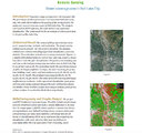
Remote sensing: green coverage area in Salt Lake City
ir_etd
InteractiveResource
13
Using an optimal estimation algorithm to describe the mass-dimensional properties of ice clouds
ir_etd
Text
1
-
25
of
13