|
|
Title | Collection Number And Name | Photo Number |
| 201 |
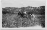 |
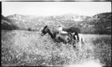
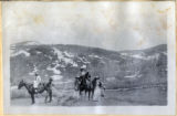
Man with three horses at the HWE ranch in Kane County | P1651 John Esplin Photograph Collection | p1651n01_01_22 |
| 202 |
 |
On the trail to the Esplin ranch | P1651 John Esplin Photograph Collection | p1651n01_08_087 |
| 203 |
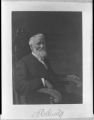 |
Portrait of a man | P1651 John Esplin Photograph Collection | p1651n01_08_042 |
| 204 |
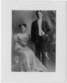 |
Portrait of a man and woman (not a negative) | P1651 John Esplin Photograph Collection | p1651n01_07_08 |
| 205 |
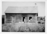 |
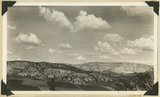
Esplin Ranch . The HWE ranch in Kane County | P1651 John Esplin Photograph Collection | p1651n01_01_25 |
| 206 |
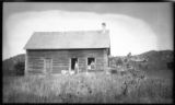 |
Esplin Ranch in Kane County | P1651 John Esplin Photograph Collection | p1651n01_07_01 |
| 207 |
 |
Five children at Esplin home on Sand Street | P1651 John Esplin Photograph Collection | p1651n01_08_076 |
| 208 |
 |
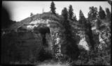
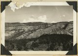
Seth Canyon at Esplin ranch | P1651 John Esplin Photograph Collection | p1651n01_08_034 |
| 209 |
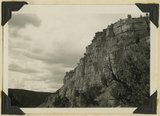 |
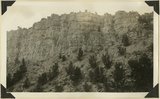
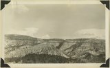
Straight Cliffs formation (Cretaceous). Orderville, Kane County, Utah. 1936 | P0013 Herbert E. Gregory Photograph Collection | P0013n10_197_2440 |
| 210 |
 |
Straight Cliffs, sandstone Cretaceous above Tropic shale. Orderville, Kane County, Utah, 1932. | P0013 Herbert E. Gregory Photograph Collection | P0013n10_118_2288 |
| 211 |
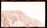 |
Straight Cliffs, sandstone north of Orderville, Kane County, Utah, 1932. | P0013 Herbert E. Gregory Photograph Collection | P0013n10_119_2289 |
| 212 |
 |
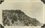
Tropic shale Muddy Brook Valley west of Orderville, Kane County, Utah, 1932. | P0013 Herbert E. Gregory Photograph Collection | P0013n10_119_2290 |
| 213 |
 |
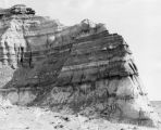
Base of Straight Cliffs formation (Cretaceous) at Orderville. Tropic shale forms slope at bottom. Kane County, UT, 1939 | P0013 Herbert E. Gregory Photograph Collection | P0013n11_045_2598 |
| 214 |
 |
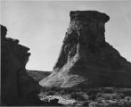
Elkheart Cliffs, blood-red buttes at base, on east side of the Sevier fault near Orderville,Kane County, Utah, 1937. | P0013 Herbert E. Gregory Photograph Collection | P0013n10_196_2436 |
| 215 |
 |
Straight Cliffs, sandstone north of Orderville, Kane County, Utah, 1932. | P0013 Herbert E. Gregory Photograph Collection | P0013n10_119_2289 |
| 216 |
 |
Tilted block broken from Sevier fault, Navajo capped by Carmel. Orderville, Kane County, Utah, 1937. | P0013 Herbert E. Gregory Photograph Collection | P0013n10_198_2442 |
| 217 |
 |
Alluvial terraces, Parunuweap Valley between Orderville and Mt. Carmel. Lie unevenly on Tropic shale. Kane County, UT. 1937 | P0013 Herbert E. Gregory Photograph Collection | P0013n11_022_2557 |
| 218 |
 |
Looking north along Sevier fault at Orderville. Right, Carmel and Navajo; left, Straight Cliffs formation (Crfetaceous). Kane County, Utah, 1936. | P0013 Herbert E. Gregory Photograph Collection | P0013n10_139_2326 |
| 219 |
 |
Six people and three horses - on Cedar Mtn, perhaps on the way from Esplin ranch to Cedar City | P1651 John Esplin Photograph Collection | p1651n01_09_19 |
| 220 |
 |
View looking east across "The Cove," near Orderville: foreground, topmost Jurassic and Tropic formation; distance, Elkheart Cliffs, Navajo capped by Carmel. Kane County, Utah, 1938. | P0013 Herbert E. Gregory Photograph Collection | P0013n10_226_2495 |
| 221 |
 |
Elkheart Cliffs along highway about mile north of Orderville. Background and right foreground Navajo sandstone capped by Carmel formation. Left foreground slice of cliff dropped down along Sevier fault. Kane County, Utah, 1932. | P0013 Herbert E. Gregory Photograph Collection | P0013n10_120_2291 |
| 222 |
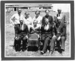 |
Group picture of the family of Charles Negus Carroll and Kezia Giles Carroll | P1651 John Esplin Photograph Collection | p1651n01_04_09 |
| 223 |
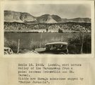 |
Looking east across valley of the Parunuweap from a point between Orderville and Mt. Carmel. Cliffs are Navajo sandstone capped by 'Marine Jurassic' | P0013 Herbert E. Gregory Photograph Collection | P0013n08_162_1643 |
| 224 |
 |
Glen Canyon | P0031 William Dawson Photograph Collection | P0031n1_09_60 |
| 225 |
 |
Glen Canyon | P0031 William Dawson Photograph Collection | P0031n1_09_61 |