|
|
Title | Collection Number And Name | Photo Number |
| 51 |
 |
Unconformity, McElmo (?) on La Plata (?) or in 2± mil. southwest of Sunrise Spgs., Arizona (photo G-43) | P0013 Herbert E. Gregory Photograph Collection | P0013n02_028_249 |
| 52 |
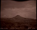 |
White Cone (Photo G256) | P0013 Herbert E. Gregory Photograph Collection | P0013n05_56_758_neg |
| 53 |
 |
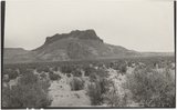
Zilh-Tusayan, igneous mass, 20± mi. northwest of Fort Defiance, Arizona, 1909 (photo G-20) | P0013 Herbert E. Gregory Photograph Collection | P0013n02_016_223 |
| 54 |
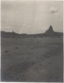 |
Agathla and Slim (Queen) Rock, Ariz., from S.E. (Photo G144) | P0013 Herbert E. Gregory Photograph Collection | P0013n04_21_0548 |
| 55 |
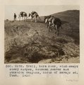 |
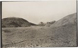
Trail, bare rock, wind-swept steep slopes, between Beaver and Junction canyons, north of Navajo Mt., Utah, 1910 (Photo G172) | P0013 Herbert E. Gregory Photograph Collection | P0013n04_50_0592 |
| 56 |
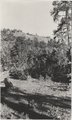
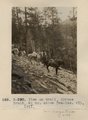 |
View on trail, Spruce Brook, 5+ mi. above Tsa-lee. VII, 1911 (Photo G-290) | P0013 Herbert E. Gregory Photograph Collection | P0013n05_77_0798 |
| 57 |
 |
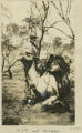
Dr. Pogue on Greybird, 1910 | P0013 Herbert E. Gregory Photograph Collection | P0013n04_72_0645 |
| 58 |
 |
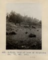
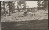
Camp 3+ mi. east of Agathla Needle, Ariz. (Photo N-M93) | P0013 Herbert E. Gregory Photograph Collection | P0013n04_34_0565a |
| 59 |
 |
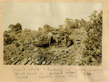
Camp at base of Baigaiche Mt. VI, 45. 1911 (Photo N-M113) | P0013 Herbert E. Gregory Photograph Collection | P0013n05_19_0703 |
| 60 |
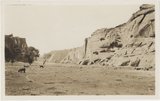 |
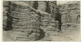
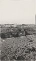
Canyon de Chelly. Shinarump capping Permian (Photo G373) | P0013 Herbert E. Gregory Photograph Collection | P0013n06_048_0924 |
| 61 |
 |
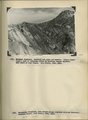
Bowers Knoll; Volcano viewed from northwest. Garfield County, UT. 1944 | P0013 Herbert E. Gregory Photograph Collection | P0013n12_076_2940B |
| 62 |
 |
Cretaceous shales (tropic formation). Antimony Canyon, Garfield County, UT. 1943 | P0013 Herbert E. Gregory Photograph Collection | P0013n12_010_2854A |
| 63 |
 |
H.E.G. and "Bubbles" | P0013 Herbert E. Gregory Photograph Collection | P0013n13_106_9-3183 |
| 64 |
 |
Herbert E. Gregory Book 12: Colorado Plateau, Province, 1942-1944 | P0013 Herbert E. Gregory Photograph Collection | P0013n12 |
| 65 |
 |
West wall of Seaman Wash | P0013 Herbert E. Gregory Photograph Collection | P0013n12_032_2880 |
| 66 |
 |
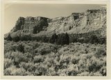
Basalt-capped mesa on Dolores (Triassic), 6± miles south of Beddehoche (Indian Wells), Ariz., 1909 (photo G-67) | P0013 Herbert E. Gregory Photograph Collection | P0013n02_039_274 |
| 67 |
 |
Basalt-capped mesa on Dolores (Triassic), 8± miles south of Beddehoche, Ariz., 1909 (photo G-68) | P0013 Herbert E. Gregory Photograph Collection | P0013n02_039_275 |
| 68 |
 |
Beautiful Valley." Fossil forest (Dolores strata), 12± mi. north of Ganado, Ariz. All pebbles in foreground are petrified wood, 1909 (photo G-28) | P0013 Herbert E. Gregory Photograph Collection | P0013n02_022_234 |
| 69 |
 |
Beautiful Valley." Fossil forest, Dolores strata, petrified log, 1909 (photo G-29) | P0013 Herbert E. Gregory Photograph Collection | P0013n02_022_235 |
| 70 |
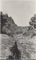 |
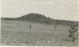
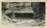
Buells Park, 12± mi. north of Ft. Defiance, Ariz. Canyon at outlet, 1909 (photo G-26) | P0013 Herbert E. Gregory Photograph Collection | P0013n02_019_229 |
| 71 |
 |
Same as G-72, nearer view: a volcanic neck, northwest of Chandler's Ranch (photo G-73) | P0013 Herbert E. Gregory Photograph Collection | P0013n02_041_280 |
| 72 |
 |
Top of plateau near Sawmill, 16± mi. northwest of Fort Defiance, Ariz. Trees are yellow pines and scrup oaks, 1909 (photo G-22) | P0013 Herbert E. Gregory Photograph Collection | P0013n02_017_225 |
| 73 |
 |
Twin Buttes south of Biddehoche, Arizona, looking west, 1909 (photo G-60) | P0013 Herbert E. Gregory Photograph Collection | P0013n02_036_267 |
| 74 |
 |
David White & Gregory at "Fern Quarry"; fossil ferns in Hermit Shale. Yaki trail... 1928 | P0013 Herbert E. Gregory Photograph Collection | P0013n01_21b_049 |
| 75 |
 |
Erosion in Entrada sandstone Dry wash. Edna Hope Gregory. San Juan County, UT, 1927 | P0013 Herbert E. Gregory Photograph Collection | P0013n09_072_1857 |