Over 70,000 photos covering a variety of topics from Marriott Library Special Collections
TO
Filters: Collection: "uum_map"
| Title | Collection Number And Name | Photo Number | ||
|---|---|---|---|---|
| 526 |
 |
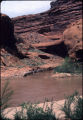
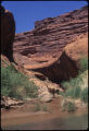
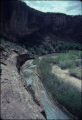
Escalante River below Stevens Arch [2] | P0796 Bill Wolverton Photograph Collection | P0796n01_07_02 |
| 527 |
 |
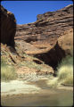
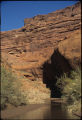
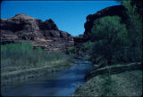
Escalante River below Stevens Arch [3] | P0796 Bill Wolverton Photograph Collection | P0796n01_07_03 |
| 528 |
 |
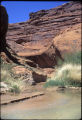
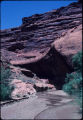
Escalante River below Stevens Arch [4] | P0796 Bill Wolverton Photograph Collection | P0796n01_07_04 |
| 529 |
 |
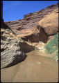
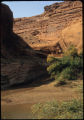
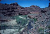
Escalante River meets Coyote Gulch, Utah [01] | P0796 Bill Wolverton Photograph Collection | P0796n01_05_01 |
| 530 |
 |
Escalante River meets Coyote Gulch, Utah [02] | P0796 Bill Wolverton Photograph Collection | P0796n01_05_02 |
| 531 |
 |
Escalante River meets Coyote Gulch, Utah [03] | P0796 Bill Wolverton Photograph Collection | P0796n01_05_03 |
| 532 |
 |
Escalante River meets Coyote Gulch, Utah [04] | P0796 Bill Wolverton Photograph Collection | P0796n01_05_04 |
| 533 |
 |
Escalante River meets Coyote Gulch, Utah [05] | P0796 Bill Wolverton Photograph Collection | P0796n01_05_05 |
| 534 |
 |
Escalante River meets Coyote Gulch, Utah [06] | P0796 Bill Wolverton Photograph Collection | P0796n01_05_06 |
| 535 |
 |
Escalante River meets Coyote Gulch, Utah [07] | P0796 Bill Wolverton Photograph Collection | P0796n01_05_07 |
| 536 |
 |
Escalante River meets Coyote Gulch, Utah [08] | P0796 Bill Wolverton Photograph Collection | P0796n01_05_08 |
| 537 |
 |
Escalante River meets Coyote Gulch, Utah [09] | P0796 Bill Wolverton Photograph Collection | P0796n01_05_09 |
| 538 |
 |
Escalante River meets Coyote Gulch, Utah [10] | P0796 Bill Wolverton Photograph Collection | P0796n01_05_10 |
| 539 |
 |
Escalante River meets Coyote Gulch, Utah [11] | P0796 Bill Wolverton Photograph Collection | P0796n01_05_11 |
| 540 |
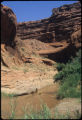 |
Escalante River meets Coyote Gulch, Utah [12] | P0796 Bill Wolverton Photograph Collection | P0796n01_05_12 |
| 541 |
 |
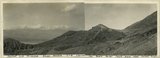
Escalante Valley, looking northeast from a point one mile west of Escalante Village. Garfield County, UT. June 1918 | P0013 Herbert E. Gregory Photograph Collection | P0013n08_105_1509 |
| 542 |
 |
Faulted and dissected gravel deposits lying against the Death Valley Fault scarp near Mormon Point | P0013 Herbert E. Gregory Photograph Collection | P0013n09_025_1768 |
| 543 |
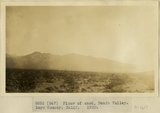 |
Floor of sand, Death Valley. Inyo County, CA. 1922 | P0013 Herbert E. Gregory Photograph Collection | P0013n08_155_1617 |
| 544 |
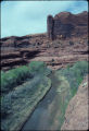 |
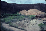
Harris Wash, Utah [1] | P0796 Bill Wolverton Photograph Collection | P0796n01_17_03 |
| 545 |
 |
Harris Wash, Utah [2] | P0796 Bill Wolverton Photograph Collection | P0796n01_17_04 |
| 546 |
 |
Harris Wash, Utah [3] | P0796 Bill Wolverton Photograph Collection | P0796n01_17_01 |
| 547 |
 |
Harris Wash, Utah [4] | P0796 Bill Wolverton Photograph Collection | P0796n01_17_02 |
| 548 |
 |
Harris Wash, Utah [5] | P0796 Bill Wolverton Photograph Collection | P0796n01_17_05 |
| 549 |
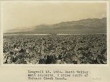 |
Longwell 13, Death Valley salt deposits, 9 miles south of Furnace Creek Ranch | P0013 Herbert E. Gregory Photograph Collection | P0013n08_190_1715 |
| 550 |
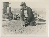 |
Man and cat, Paria Valley camp, 1943 | P0013 Herbert E. Gregory Photograph Collection | P0013n16_11_14 |