|
|
Title | Collection Number And Name | Photo Number |
| 26 |
 |
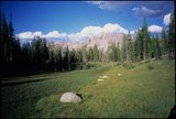
Middle East church | P0561 Wallace Stegner Photograph Collection | p0561n05_015 |
| 27 |
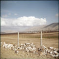 |
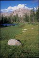
Landscape | P0561 Wallace Stegner Photograph Collection | p0561n05_019 |
| 28 |
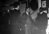 |
Representative Lloyd on Middle-east Trip, January 1970. | P0045 Sherm Lloyd Photograph Collection | p0045n01_22_191 |
| 29 |
 |
Representative Lloyd on Middle-east Trip, January 1970. | P0045 Sherm Lloyd Photograph Collection | p0045n01_22_192 |
| 30 |
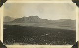 |
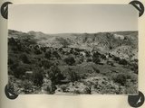
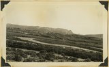
Looking across Big Plains toward Smithsonian Butte (middle background), West Temple (upper right). Foreground forested east slope of Little Creek Mountain, Shinarump; middle distance, dry farm lands on Chinle strata. Washington County, Utah, 1937. | P0013 Herbert E. Gregory Photograph Collection | P0013n10_173_2390 |
| 31 |
 |
Middle East street scene | P0053 Hortense Redd Erickson lantern slide collection, 1920-1929 | P0053n01_G020 |
| 32 |
 |
Modern building, Middle East | P0053 Hortense Redd Erickson lantern slide collection, 1920-1929 | P0053n01_G024 |
| 33 |
 |
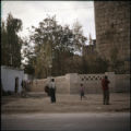
Unidentified fortress, Middle East | P0561 Wallace Stegner Photograph Collection | p0561n05_013 |
| 34 |
 |
Unidentified fortress, Middle East | P0561 Wallace Stegner Photograph Collection | p0561n05_012 |
| 35 |
 |
Middle East street scene | P0053 Hortense Redd Erickson lantern slide collection, 1920-1929 | P0053n01_G021 |
| 36 |
 |
Group portrait of the Eastern States Missionaries, Andrus is in the middle row, second from the left | P0598 Charles H. Andrus photograph collection | P0598n01_02_003 |
| 37 |
 |
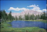
Ryder Lake and Middle Basin [03] | P2162 Bear River Portfolio by Craig Denton | P2162n04_11_003 |
| 38 |
 |
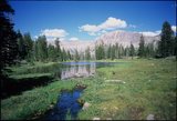
Ryder Lake and Middle Basin [04] | P2162 Bear River Portfolio by Craig Denton | P2162n04_11_004 |
| 39 |
 |
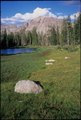
Ryder Lake and Middle Basin [05] | P2162 Bear River Portfolio by Craig Denton | P2162n04_11_005 |
| 40 |
 |
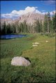
Ryder Lake and Middle Basin [06] | P2162 Bear River Portfolio by Craig Denton | P2162n04_11_006 |
| 41 |
 |
Ryder Lake and Middle Basin [07] | P2162 Bear River Portfolio by Craig Denton | P2162n04_11_007 |
| 42 |
 |
Ryder Lake and Middle Basin [08] | P2162 Bear River Portfolio by Craig Denton | P2162n04_11_008 |
| 43 |
 |
Ryder Lake and Middle Basin [09] | P2162 Bear River Portfolio by Craig Denton | P2162n04_11_009 |
| 44 |
 |
Ryder Lake and Middle Basin [10] | P2162 Bear River Portfolio by Craig Denton | P2162n04_11_010 |
| 45 |
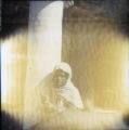 |
Child near a column | P0561 Wallace Stegner Photograph Collection | p0561n05_028 |
| 46 |
 |
Looking southward across House Rock Valley from West Clark Bench. West dipping Navajo sandstone trenched by Kaibab Creek (middle distance) is a part of the East Kaibab monocline; east dipping limestones (skyline) are the cap rocks of the Kaibab upwarp. Kane County, UT, 1944 | P0013 Herbert E. Gregory Photograph Collection | P0013n12_035_2882 |
| 47 |
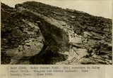 |
Water Pocket Fold. East entrance to Muley Twist Trail. Wingate and Middle LaPlata. Kane County, UT. June 1918 | P0013 Herbert E. Gregory Photograph Collection | P0013n08_080_1457 |
| 48 |
 |
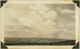
Looking east across Sevier River near Hatch River terraces in middle distance, "Pink Cliffs" (Wasatch) in background bounded by Sevier fault. Garfield County, Utah, 1936. | P0013 Herbert E. Gregory Photograph Collection | P0013n10_147_2341 |
| 49 |
 |
Looking northwest across Parunuweap east of Mt. Carmel, Cretaceous in middle ground, Pink Cliffs in distance, 1936. | P0013 Herbert E. Gregory Photograph Collection | P0013n10_150_2345 |
| 50 |
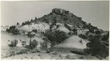 |
Moenkopi formation: Shnabkaib member (lower part), upper red sandstone (upper middle), Shinarump conglomerate (top). East side of Seamans Wash, Kane County, UT. 1943 | P0013 Herbert E. Gregory Photograph Collection | P0013n12_027_2877D |