|
|
Title | Collection Number And Name | Photo Number |
| 1 |
 |
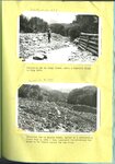
Shoal Creek Dam : Excavation for Shoal Creek diversion dam above Enterprise [and] The same after dam was finally completed | P0208 Utah Flood Survey photograph collection | P0208n01_01_062-063 |
| 2 |
 |
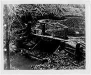
Diversion dam on Canal Creek, after a terrific flood in July 1922 [and] Diversion dam on Haights Creek, buried by a devastating flood July 3, 1926 | P0208 Utah Flood Survey photograph collection | P0208n01_01_072-073 |
| 3 |
 |
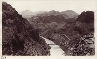
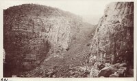
Geology field trip, Fall 1929: Black Canyon of the Colorado | P0268 Frederick J. Pack photograph collection | P0268n01_13_801 |
| 4 |
 |
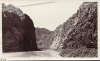
Geology field trip, Fall 1929: Black Canyon of the Colorado | P0268 Frederick J. Pack photograph collection | P0268n01_13_802 |
| 5 |
 |
Geology field trip, Fall 1929: Black Canyon of the Colorado | P0268 Frederick J. Pack photograph collection | P0268n01_13_800 |
| 6 |
 |
Shoal Creek Dam : Looking up stream through spillway of Shoal Creek diversion dam [and] The same looking down stream | P0208 Utah Flood Survey photograph collection | P0208n01_01_064-065 |
| 7 |
 |
Summit Flood Control Dam : Constructing flood control diversion dam at Summit [and] The same after completion and after a terrific summer flood carrying boulders weighing tons each | P0208 Utah Flood Survey photograph collection | P0208n01_01_068-069 |
| 8 |
 |
Malaria control engineering, South Pacific [02] | P0490 Arden R. Gaufin photograph collection | P0490n01_03_002 |
| 9 |
 |
Geology field trip, Fall 1929: Black Canyon of the Colorado | P0268 Frederick J. Pack photograph collection | P0268n01_13_808 |
| 10 |
 |
Geology field trip, Fall 1929: Colorado River - at Laguna | P0268 Frederick J. Pack photograph collection | P0268n01_13_835 |
| 11 |
 |
Geology field trip, Fall 1929: Colorado River - at Laguna | P0268 Frederick J. Pack photograph collection | P0268n01_13_836 |
| 12 |
 |
Geology field trip, Fall 1929: Black Canyon of the Colorado | P0268 Frederick J. Pack photograph collection | P0268n01_13_806 |
| 13 |
 |
Geology field trip, Fall 1929: Black Canyon of the Colorado | P0268 Frederick J. Pack photograph collection | P0268n01_13_807 |
| 14 |
 |
Malaria control area, Luzon [12] | P0490 Arden R. Gaufin photograph collection | P0490n01_02_012 |
| 15 |
 |
Enterprise flood dam in process of construction | P0208 Utah Flood Survey photograph collection | P0208n01_01_110 |
| 16 |
 |
Haights Creek Diversion dam in process of construction | P0208 Utah Flood Survey photograph collection | P0208n01_01_102 |
| 17 |
 |
Diversion dam above Orderville [and] Diversion dam above Escalante in Potato Valley | P0208 Utah Flood Survey photograph collection | P0208n01_01_070-071 |
| 18 |
 |
Strawberry Reservoir Dam | P0268 Frederick J. Pack photograph collection | P0268n01_12_699 |
| 19 |
 |
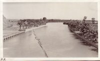
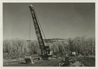
Wanship Dam construction, Weber Basin, ca. 1955 [02] | P0847 Noel R. Barton Photograph Collection | P0847n02_07_002 |
| 20 |
 |
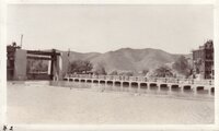
Wanship Dam construction, Weber Basin, ca. 1955 [07] | P0847 Noel R. Barton Photograph Collection | P0847n02_07_007 |
| 21 |
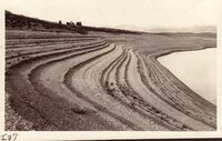 |
Bonneville Terraces, U-B Dam, Utah | P0268 Frederick J. Pack photograph collection | P0268n01_12_415 |
| 22 |
 |
Bonneville Terraces, U-B Dam, Utah | P0268 Frederick J. Pack photograph collection | P0268n01_12_420 |
| 23 |
 |
Dyke - Eroded - Near Shoshone Dam - Wyo | P0268 Frederick J. Pack photograph collection | P0268n01_13_703 |
| 24 |
 |
Flooding in Willard, Utah : "beaver dam" built by man to divert the stream (Willard Creek) into the barrier basin [and] Temporary spillway just above highway crossing | P0208 Utah Flood Survey photograph collection | P0208n01_01_019-020 |
| 25 |
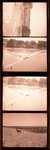 |
Views of the Iowa River dam and dog, Iowa City, Iowa | P0316 Vern Adix Photograph Collection | P0316n28_15_9636 |