Home
Browse
Ask Us
Chat
Harmful Language Statement
Log in
Photo Archives
Advanced Search
About
Over 70,000 photos covering a variety of topics from Marriott Library Special Collections
Year
1800
1801
1802
1803
1804
1805
1806
1807
1808
1809
1810
1811
1812
1813
1814
1815
1816
1817
1818
1819
1820
1821
1822
1823
1824
1825
1826
1827
1828
1829
1830
1831
1832
1833
1834
1835
1836
1837
1838
1839
1840
1841
1842
1843
1844
1845
1846
1847
1848
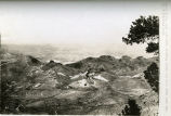
1849
1850
1851
1852
1853
1854
1855
1856
1857
1858
1859
1860
1861
1862
1863
1864
1865
1866
1867
1868
1869
1870
1871
1872
1873
1874
1875
1876
1877
1878
1879
1880
1881
1882
1883
1884
1885
1886
1887
1888
1889
1890
1891
1892
1893
1894
1895
1896
1897
1898
1899
1900
1901
1902
1903
1904
1905
1906
1907
1908
1909
1910
1911
1912
1913
1914
1915
1916
1917
1918
1919
1920
1921
1922
1923
1924
1925
1926
1927
1928
1929
1930
1931
1932
1933
1934
1935
1936
1937
1938
1939
1940
1941
1942
1943
1944
1945
1946
1947
1948
1949
1950
1951
1952
1953
1954
1955
1956
1957
1958
1959
1960
1961
1962
1963
1964
1965
1966
1967
1968
1969
1970
1971
1972
1973
1974
1975
1976
1977
1978
1979
1980
1981
1982
1983
1984
1985
1986
1987
1988
TO
1800
1801
1802
1803
1804
1805
1806
1807
1808
1809
1810
1811
1812
1813
1814
1815
1816
1817
1818
1819
1820
1821
1822
1823
1824
1825
1826
1827
1828
1829
1830
1831
1832
1833
1834
1835
1836
1837
1838
1839
1840
1841
1842
1843
1844
1845
1846
1847
1848
1849
1850
1851
1852
1853
1854
1855
1856
1857
1858
1859
1860
1861
1862
1863
1864
1865
1866
1867
1868
1869
1870
1871
1872
1873
1874
1875
1876
1877
1878
1879
1880
1881
1882
1883
1884
1885
1886
1887
1888
1889
1890
1891
1892
1893
1894
1895
1896
1897
1898
1899
1900
1901
1902
1903
1904
1905
1906
1907
1908
1909
1910
1911
1912
1913
1914
1915
1916
1917
1918
1919
1920
1921
1922
1923
1924
1925
1926
1927
1928
1929
1930
1931
1932
1933
1934
1935
1936
1937
1938
1939
1940
1941
1942
1943
1944
1945
1946
1947
1948
1949
1950
1951
1952
1953
1954
1955
1956
1957
1958
1959
1960
1961
1962
1963
1964
1965
1966
1967
1968
1969
1970
1971
1972
1973
1974
1975
1976
1977
1978
1979
1980
1981
1982
1983
1984
1985
1986
1987
1988
Type
Image
134
Format
image/jpeg
130
application/pdf
4
Collection Name
H.W. Bailey
77
Vern Adix
39
Joy Ungricht
5
Olive Woolley Burt
3
Rosezella Dalton Hardy
3
Everett Ruess Family
2
Shipler Studio
2
Alta Club
1
Hiram B. Clawson
1
Wallace Stegner
1
More
Filters:
Collection:
"uum_map"
Type:
"Image"
51
-
75
of
134
<
1
2
3
4
5
6
>
Gallery view
Number of results to display per page
10
25
50
100
200
Sort by Relevance
Sort by Title A-Z
Sort by Title Z-A
Sort by Date Ascending
Sort by Date Descending
Sort by Last Modified Ascending
Sort by Last Modified Descending
Sort by Photo Number
Title
Collection Number And Name
Photo Number
51
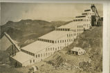
Nevada Hills Mine and Mill; looking North and West from near summit of Fairview Peak
P0023 H.W. Bailey Photograph Collection
p0023n76
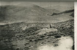
52
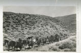
On the road to the Nevada Hills Mines, Fairview, Nevada
P0023 H.W. Bailey Photograph Collection
p0023n64
53
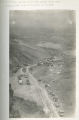
Town of Fairview looking North from Nevada Hills Mine; showing (Old) Town of Fairview in distance
P0023 H.W. Bailey Photograph Collection
p0023n67
54
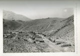
The town of Fairview, Nevada (New Town) looking South towards the hill and mine
P0023 H.W. Bailey Photograph Collection
p0023n65
55
Nevada Hills Mine and Mill; looking Northwest; showing residences, offices and headframe; Fairview, Nevada; Churchhill County
P0023 H.W. Bailey Photograph Collection
p0023n70
56
Smith - Bailey Drug Company
P0790 Shipler Studio Photograph Collection
P0790n1_13_03
57
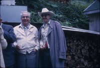
Paul Bailey and Nelson Nye at WAA Convention, 1964
P0244 Olive Woolley Burt Photograph Collection
P0244n3_60_0770
58
Nevada Hills Mill and surroundings; looking Northeast
P0023 H.W. Bailey Photograph Collection
p0023n73
59
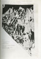
Photographic copy of U.S. Geologic Survey Publication Geological Chart of the State of Nevada; Showing location of Fairview, Churchill County, Nevada
P0023 H.W. Bailey Photograph Collection
p0023n63
60
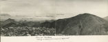
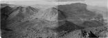
View of Mountains looking south east from summit of Eagle Mountain
P0023 H.W. Bailey Photograph Collection
p0023n43
61
First Unitarian Church, Los Angeles
P1194 Everett Ruess Family Photograph Collection
P1194n02_04_016
62
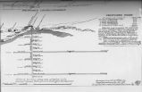
General plat of proposed work on Ophir Lode Claims; 1910-1914
P0023 H.W. Bailey Photograph Collection
p0023n35
63
Geological Sheet - Ophir Lode Claims; 1910-1914
P0023 H.W. Bailey Photograph Collection
p0023n34
64
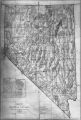
Map of Nevada 1908; Photographic copy of General Land Office Mape of the State of Nevada, with location of Ophir Mines drawn in
P0023 H.W. Bailey Photograph Collection
p0023n29
65
Nevada Mineral Districts 1912; Photographic copy of Map of Nevada showing location of Mining Districts and Ophir Mines
P0023 H.W. Bailey Photograph Collection
p0023n30
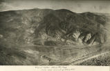
66
Ophir Camp, Birds eye. Neco mining district - Nevada
P0023 H.W. Bailey Photograph Collection
p0023n27
67
Photographic copy of U.S. Geologic Survey Publication Geological Chart of the State of Nevada, with location of Ophir Mines drawn in
P0023 H.W. Bailey Photograph Collection
p0023n28
68
Prospective work - construction and installations on Ophir Mines;1910-1914
P0023 H.W. Bailey Photograph Collection
p0023n36
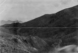
69
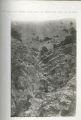
Rock Canyon near Nevada Hills Mine; big strike was made here in 1908
P0023 H.W. Bailey Photograph Collection
p0023n66
70
View of Eagle Mountain, Ophir Peak and Olive Mountain
P0023 H.W. Bailey Photograph Collection
p0023n52
71
View of Ophir Mines and Peak from near summit of Olive Mountain
P0023 H.W. Bailey Photograph Collection
p0023n41
72
Birds eye view of Rawhide Nevada and vicinity of Ophir Camp
P0023 H.W. Bailey Photograph Collection
p0023n23
73
General Map of Ophir Lode Claims; showing trend of lodes, contours, etc; 1910-1914
P0023 H.W. Bailey Photograph Collection
p0023n33
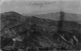
74
Looking East Scotchman Peak showing Ophir group and principal workings thereof
P0023 H.W. Bailey Photograph Collection
p0023n25
75
Ore dump and waste dump on Golden Gate Lode Claim of Eagle Group of Mines Mineral County, Nevada; looking Southeast from point near camp on Golden Gate Lode.
P0023 H.W. Bailey Photograph Collection
p0023n09
51
-
75
of
134
<
1
2
3
4
5
6
>