Home
Browse
Ask Us
Chat
Harmful Language Statement
Log in
Photo Archives
Advanced Search
About
Over 90,000 photos covering a variety of topics from Marriott Library Special Collections.
Year
1820
1821
1822
1823
1824
1825
1826
1827
1828
1829
1830
1831
1832
1833
1834
1835
1836
1837
1838
1839
1840
1841
1842
1843
1844
1845
1846
1847
1848
1849
1850
1851
1852
1853
1854
1855
1856
1857
1858
1859
1860
1861
1862
1863
1864
1865
1866
1867
1868
1869
1870
1871
1872
1873
1874
1875
1876
1877
1878
1879
1880
1881
1882
1883
1884
1885
1886
1887
1888
1889
1890
1891
1892
1893
1894
1895
1896
1897
1898
1899
1900
1901
1902
1903
1904
1905
1906
1907
1908
1909
1910
1911
1912
1913
1914
1915
1916
1917
1918
1919
1920
1921
1922
1923
1924
1925
1926
1927
1928
1929
1930
1931
1932
1933
1934
1935
1936
1937
1938
1939
1940
1941
1942
1943
1944
1945
1946
1947
1948
1949
1950
1951
1952
1953
1954
1955
1956
1957
1958
1959
1960
1961
1962
1963
1964
1965
1966
1967
1968
1969
1970
1971
1972
1973
1974
1975
1976
1977
1978
1979
1980
1981
1982
1983
1984
1985
1986
1987
1988
1989
1990
1991
1992
1993
1994
1995
1996
1997
1998
1999
2000
2001
2002
TO
1820
1821
1822
1823
1824
1825
1826
1827
1828
1829
1830
1831
1832
1833
1834
1835
1836
1837
1838
1839
1840
1841
1842
1843
1844
1845
1846
1847
1848
1849
1850
1851
1852
1853
1854
1855
1856
1857
1858
1859
1860
1861
1862
1863
1864
1865
1866
1867
1868
1869
1870
1871
1872
1873
1874
1875
1876
1877
1878
1879
1880
1881
1882
1883
1884
1885
1886
1887
1888
1889
1890
1891
1892
1893
1894
1895
1896
1897
1898
1899
1900
1901
1902
1903
1904
1905
1906
1907
1908
1909
1910
1911
1912
1913
1914
1915
1916
1917
1918
1919
1920
1921
1922
1923
1924
1925
1926
1927
1928
1929
1930
1931
1932
1933
1934
1935
1936
1937
1938
1939
1940
1941
1942
1943
1944
1945
1946
1947
1948
1949
1950
1951
1952
1953
1954
1955
1956
1957
1958
1959
1960
1961
1962
1963
1964
1965
1966
1967
1968
1969
1970
1971
1972
1973
1974
1975
1976
1977
1978
1979
1980
1981
1982
1983
1984
1985
1986
1987
1988
1989
1990
1991
1992
1993
1994
1995
1996
1997
1998
1999
2000
2001
2002
Type
Image
2,002
Image/StillImage
467
Format
image/jpeg
2,655
application/pdf
210
Collection Name
Shipler Studio
1,030
Sheepherding
227
Olive Woolley Burt
165
Utah Schools photograph collection
112
Wasatch Mountain Club
110
Edward Hunter Family
73
George D. Pyper
69
Salt Lake Chamber of Commerce photograph collection
68
Wallace and Mary Doi
60
Lyman P. Hunter
52
J. Willard and Alice Sheets Marriott
50
Frederick J. Pack
46
Stephanie Young Merzel
45
Clifford Percy Evans
44
Environmental Geology in Utah
43
Ivor Sharp
39
Rocky Mountain Power Company
36
William M. Purdy
34
Herbert E. Gregory
32
MX photograph collection
30
Robert Heiner Garff
29
Alvin G. and Lena M. Pack
27
Helen Bowring Ure photograph collection
26
Gary Dean Brown
23
Greek Archives
22
Elbert Thomas
20
C. Lowell Lees
19
Utah interurban railroads
19
John Stockert
18
Mickey Ibarra
17
Joseph Kingsbury
16
Waldo Wilcox
15
Lynn Larsen
14
Southern Slavic
13
Charles Kelly
12
Frank Filkins
12
William Dawson
12
United States Fuel Corporation
11
Utah Railroads
9
Everett Ruess Family
8
The Triumphal Return of the Utah Volunteers
8
American Civil Liberties Union of Utah
7
Glade Peterson photograph collection
6
Lowell Lindsay Bennion
6
Orange A. Olsen photograph collection
6
Portrait
6
Clarence Stevenson
5
Henry Y. Kasai
5
Julia Farnsworth Lund Wassmer
5
Dr Robert Starr Waite
4
G. Bennet Larson
4
Gibb R. Madsen
4
Luretta Young
4
Miles Pratt Romney
4
Richard E. Westwood Photograph Collection
4
Transportation photograph collection
4
Wallace F. Bennett
4
Cheves Walling
3
Gus Scott
3
Intermountain Conference on Children's Literature
3
John W. Summerhays
3
Ole Pettit
3
Topaz, Utah and Hispanics in Utah films, 1940-1990
3
A. Wally Sandack
2
Alpine Mountain Club
2
Anne Marie Fox Felt
2
Brigham Young Family
2
Charles Neal
2
Frederick Hoffman Wood
2
Italian
2
LDS Church History
2
Leo Leonard
2
Lowry Nelson
2
Maurice Abravanel
2
Reva Beck Bosone
2
Wallace Stegner
2
Walter H. and Ann S. Huish photograph collection
2
William Dawson photograph collection
2
William F. Bulkley
2
A. Selden Millward
1
Allen Publishing Company
1
American Red Cross
1
Blanche Kendall McKey
1
Deseret Livestock Company
1
Edward P. Jennings
1
Ezra T. Clark photograph collection
1
Hampton C. Godbe
1
Hiram B. Clawson
1
John Hamilton Morgan
1
Mary Jane Mount Tanner
1
Rosezella Dalton Hardy
1
S.J. Quinney
1
Salt Lake Oratorio Society photograph collection
1
Sherm Lloyd
1
Sonia Johnson
1
Standley Hunter Rich
1
Stanley Murdock
1
Utah Flood Survey
1
Utah Humanities Research Foundation
1
Utah Test and Training Range
1
Western and Mormon stereograph collection
1
More
Filters:
Collection:
"uum_map"
Spatial Coverage:
"Utah"
2851
-
2875
of
2,865
<
106
107
108
109
110
111
112
113
114
115
>
Gallery view
Number of results to display per page
10
25
50
100
200
Sort by Relevance
Sort by Title A-Z
Sort by Title Z-A
Sort by Date Ascending
Sort by Date Descending
Sort by Last Modified Ascending
Sort by Last Modified Descending
Sort by Photo Number
Title
Collection Number And Name
Photo Number
2851
Hydrograph depicting flow for the year 1945 of Utah's second largest spring, Swan Creek Spring, west of Bear Lake in northern Utah. Note the fluctuation in flow from April to September. Note also rapid response to spring snowmelt (April and May) and rainfall (June and July). The rock from which the spring issues (aquifer) is limestone. The graph illustrates the importance of controlling development on limestone terrain.
P1274 Environmental Geology and Geologic Hazards in Utah Photograph Collection
p1274n067
2852
Surficial or shallow ground water is subject to pollution from buried solid wastes. Leaching of the wastes can occur in time. This excavation is for a land fill operation where ground water was encountered at a depth of less than 6 feet.
P1274 Environmental Geology and Geologic Hazards in Utah Photograph Collection
p1274n072
2853
Swelling of clay soil as it takes on additional moisture heaved up this garage floor and cracked it.
P1274 Environmental Geology and Geologic Hazards in Utah Photograph Collection
p1274n075
2854
This water storage reservoir has failed; it was placed improperly upon a stratum of gypsum (white layers in photo) which partially dissolved.
P1274 Environmental Geology and Geologic Hazards in Utah Photograph Collection
p1274n076
2855
Crack in soil alongside reservoir, showing subsidence. Reservoir was the only water storage facility serving several thousand people.
P1274 Environmental Geology and Geologic Hazards in Utah Photograph Collection
p1274n077
2856
These twin tanks deverge from bottom to top. Differential settling of their foundations caused this.
P1274 Environmental Geology and Geologic Hazards in Utah Photograph Collection
p1274n078
2857
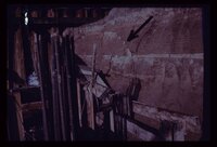
Arrow points to incipient failure of an excavation wall for a foundation for a multistory office building. Material is horizontally stratified Lake Bonneville silts and sands.
P1274 Environmental Geology and Geologic Hazards in Utah Photograph Collection
p1274n080
2858
The circumstances here probably make a utility trench cave-in inevitable. A perched water table is sapping fine sand from underneath a thick silt bed, leaving the latter unsupported. Failure will be too rapid for escape of a workman who may be in the trench at the wrong moment.
P1274 Environmental Geology and Geologic Hazards in Utah Photograph Collection
p1274n082
2859
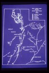
Map of Utah showing the 5 major active fault zones in the state.
P1274 Environmental Geology and Geologic Hazards in Utah Photograph Collection
p1274n085
2860
Exposure of a branch of the Wasatch Fault in a sand and gravel pit along the mountain front. Amount of displacement is indeterminable from the stratigraphy exposed. Note that the fault is planar and stands out with relative resistance to the elements despite lack of cementation of the sand and gravel.
P1274 Environmental Geology and Geologic Hazards in Utah Photograph Collection
p1274n090
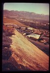
2861
Steep, high, artificial fill slopes in or near the Wasatch Fault Zone. Downslope from these fills lie dense residential developments. Atop these fills are residences. How may these earth materials be expected to react to seismic vibrations?
P1274 Environmental Geology and Geologic Hazards in Utah Photograph Collection
p1274n100
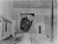
2862
Car dumper at the Magna concentrating mill. The car, with between 85 and 100 tons of ore, is turned completely over in the unloading process.
P1477 Gibb R. Madsen Photograph Collection
p1477n01_01_04
2863
Ball mills at the Magna mill. Each cylinder contains about sixty tons of steel balls, which roll as the cylinder turns, grinding the ore between the balls.
P1477 Gibb R. Madsen Photograph Collection
p1477n01_01_05
2864
A validation cell showing the valuable concentration being floated out in a bubbly froth.
P1477 Gibb R. Madsen Photograph Collection
p1477n01_01_06
2865
Inspecting and cleaning wire bars at the Garfield refinery.
P1477 Gibb R. Madsen Photograph Collection
p1477n01_01_12
2851
-
2875
of
2,865
<
106
107
108
109
110
111
112
113
114
115
>