Home
Browse
Ask Us
Chat
Harmful Language Statement
Log in
Photo Archives
Advanced Search
About
Over 90,000 photos covering a variety of topics from Marriott Library Special Collections.
Year
1911
1912
1913
1914
1915
1916
1917
1918
1919
1920
1921
1922
1923
1924
1925
1926
1927
1928
1929
1930
1931
1932
1933
1934
1935
1936
1937
1938
1939
1940
1941
1942
1943
1944
1945
1946
1947
1948
1949
1950
1951
1952
1953
1954
1955
1956
1957
1958
1959
1960
1961
1962
TO
1911
1912
1913
1914
1915
1916
1917
1918
1919
1920
1921
1922
1923
1924
1925
1926
1927
1928
1929
1930
1931
1932
1933
1934
1935
1936
1937
1938
1939
1940
1941
1942
1943
1944
1945
1946
1947
1948
1949
1950
1951
1952
1953
1954
1955
1956
1957
1958
1959
1960
1961
1962
Type
Image
154
Image/StillImage
2
Format
image/jpeg
154
application/pdf
2
Collection Name
Herbert E. Gregory
154
C. Lowell Lees
2
Filters:
Collection:
"uum_map"
Spatial Coverage:
"South America"
51
-
75
of
156
<
1
2
3
4
5
6
7
>
Gallery view
Number of results to display per page
10
25
50
100
200
Sort by Relevance
Sort by Title A-Z
Sort by Title Z-A
Sort by Date Ascending
Sort by Date Descending
Sort by Last Modified Ascending
Sort by Last Modified Descending
Sort by Photo Number
Title
Collection Number And Name
Photo Number
51
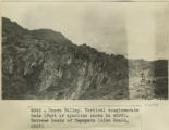
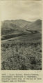
Cuzco Valley. Vertical conglomerate beds (part of syncline shown in 2987). Extreme heads of Ongapata
P0013 Herbert E. Gregory Photograph Collection
P0013n13_024_9-2993
52
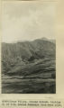
Cuzco Valley, Terrace. Ongapata. Looking upstream from 1/2 mile above mouth. Camera pointing south
P0013 Herbert E. Gregory Photograph Collection
P0013n13_024_9-2994
53
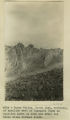
Cuzco Valley. North limb, vertical, of syncline west of Ongapata (same as syncline shown in 2996-2997) but three miles further south
P0013 Herbert E. Gregory Photograph Collection
P0013n13_025_9-2995
54
Cuzco Valley. Choquo branch. Looking S or SE across Huancaro from west side.
P0013 Herbert E. Gregory Photograph Collection
P0013n13_025_9-2996
55
Cuzco Valley Choquo branch. Looking S or SE across Huancaro from west side. (compare 2987, 2988, and 2989)
P0013 Herbert E. Gregory Photograph Collection
P0013n13_026_9-2997
56
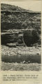
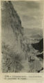
Cuzco Valley, Lava columns NE bank of Vilcanata at Sierra Bella.
P0013 Herbert E. Gregory Photograph Collection
P0013n13_026_9-2998
57
Cuzco Valley. Vilcanata Canyon, looking down stream NW from Sierra Bella.
P0013 Herbert E. Gregory Photograph Collection
P0013n13_027_9-2999
58
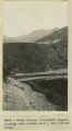
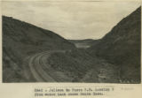
Juliaca to Cuzco R.R. Looking S from water tank above Santa Rosa.
P0013 Herbert E. Gregory Photograph Collection
P0013n13_027_9-3000
59
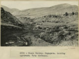
Cuzco Valley. Mouth of Huatanay, looking upstream from East side Vilcanata. Note terrace and gorge
P0013 Herbert E. Gregory Photograph Collection
P0013n13_028_9-3001
60
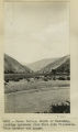
Cuzco Valley. Terrace in lake beds, south bank of Huatanay. One-half mile below junction with Huancaro
P0013 Herbert E. Gregory Photograph Collection
P0013n13_028_9-3002
61
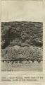
Basalt? Cliff below Rumicola Quarry
P0013 Herbert E. Gregory Photograph Collection
P0013n13_029_9-3003
62
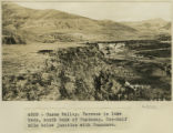
Cuzco Valley. Ongapata. Looking upstream. Note terraces
P0013 Herbert E. Gregory Photograph Collection
P0013n13_029_9-3004
63
Cuzco Valley. North bank of the Hautanay, showing buried wall South of San Sebastian.
P0013 Herbert E. Gregory Photograph Collection
P0013n13_030_9-3005
64
Cuzco Valley. North bank of the Huatanay, south of San Sebastian.
P0013 Herbert E. Gregory Photograph Collection
P0013n13_030_9-3006
65
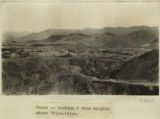
Cuzco, looking S from heights above Ttica-ttica.
P0013 Herbert E. Gregory Photograph Collection
P0013n13_031_9-3007
66
Cuzco Valley. Junction of Vilcanata and Huatanay, looking down Huatanay. Note high rock cut terrace.
P0013 Herbert E. Gregory Photograph Collection
P0013n13_031_9-3008
67
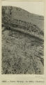
Ollantaytambo. Continuation of panorama to right
P0013 Herbert E. Gregory Photograph Collection
P0013n13_032_9-3009
68
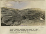
Cuzco. Rodadero Hill and Sacsahuaman hill and part of city.
P0013 Herbert E. Gregory Photograph Collection
P0013n13_032_9-3010
69
Cuzco Valley. Detail.
P0013 Herbert E. Gregory Photograph Collection
P0013n13_033_9-3011a
70
Cuzco basin. North flat, looking up Valley from 'Island' high point over 1 mile SE of San Sebastian.
P0013 Herbert E. Gregory Photograph Collection
P0013n13_033_9-3011b
71
Cuzco Basin. Looking down the Valley from 'Island' toward the narrows
P0013 Herbert E. Gregory Photograph Collection
P0013n13_034_9-3012
72
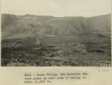
Cuzco Valley. San Geronimo fan from point on east side of valley at elev 11,000 feet.
P0013 Herbert E. Gregory Photograph Collection
P0013n13_034_9-3013
73
Cuzco Valley. North-flowing, subsequent tributary to Huatanay, entering south side of valley at West (upper) end of Narrows.
P0013 Herbert E. Gregory Photograph Collection
P0013n13_035_9-3014
74
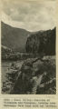
Cuzco Valley. Upper part of Angostura Narrows looking upstream.
P0013 Herbert E. Gregory Photograph Collection
P0013n13_035_9-3015
75
Cuzco Valley. Upper part of Angostura Narrows from a point on north side of Narrows, elev. 11,000 ft. (Looking down valley)
P0013 Herbert E. Gregory Photograph Collection
P0013n13_036_9-3016
51
-
75
of
156
<
1
2
3
4
5
6
7
>