Home
Browse
Ask Us
Chat
Harmful Language Statement
Log in
Photo Archives
Advanced Search
About
Over 70,000 photos covering a variety of topics from Marriott Library Special Collections
Year
1921
1922
1923
1924
1925
1926
1927
1928
1929
1930
1931
1932
1933
1934
1935
1936
1937
1938
1939
1940
1941
1942
1943
1944
1945
1946
1947
1948
1949
1950
1951
1952
1953
1954
1955
1956
1957
1958
1959
1960
1961
1962
1963
1964
1965
1966
1967
TO
1921
1922
1923
1924
1925
1926
1927
1928
1929
1930
1931
1932
1933
1934
1935
1936
1937
1938
1939
1940
1941
1942
1943
1944
1945
1946
1947
1948
1949
1950
1951
1952
1953
1954
1955
1956
1957
1958
1959
1960
1961
1962
1963
1964
1965
1966
1967
Type
Image
27
Image/StillImage
8
Format
image/jpeg
32
application/pdf
9
Collection Name
Herbert E. Gregory
20
Calumet Mining and Refining Company
7
Olive Woolley Burt
7
William Manning Green
6
Frederick J. Pack
1
Filters:
Collection:
"uum_map"
Spatial Coverage:
"San Bernardino County (Calif.)"
1
-
25
of
41
<
1
2
>
Gallery view
Number of results to display per page
10
25
50
100
200
Sort by Relevance
Sort by Title A-Z
Sort by Title Z-A
Sort by Date Ascending
Sort by Date Descending
Sort by Last Modified Ascending
Sort by Last Modified Descending
Sort by Photo Number
Title
Collection Number And Name
Photo Number
1
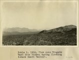
View down Wingate Wash from Hidden Spring, looking toward Death Valley
P0013 Herbert E. Gregory Photograph Collection
P0013n08_176_1686
2
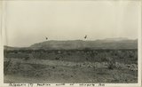
Wingate Pass from Panamint Valley
P0013 Herbert E. Gregory Photograph Collection
P0013n08_176_1687
3
View northward across valley of Wingate Wash from Hidden Spring, Paramint Mountains in background. Low hills upturned Tertiary Lake beds in foreground contain the Epsomite deposits
P0013 Herbert E. Gregory Photograph Collection
P0013n08_177_1688
4
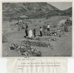
Epsomite deposits associated with Tertiary lake beds 4 miles south of Wingate Wash
P0013 Herbert E. Gregory Photograph Collection
P0013n08_177_1689
5
Epsomite deposits in tertiary lake Beds 4 miles south of Wingate Wash
P0013 Herbert E. Gregory Photograph Collection
P0013n08_178_1690
6
Looking N at Slate Range from 3200 ft. hill of fault breccia situated about 4 miles WSW of 2021 BM in Leach Trough at entrance of Paramint Valley. Outcrop of fault breccia in lower foreground
P0013 Herbert E. Gregory Photograph Collection
P0013n08_178_1691
7
Looking E along Leach Trough from 3200 ft. hill of fault breccia situated about 4 miles WSW of 2021 BM in Leach Trough at entrance of Paramint Valley
P0013 Herbert E. Gregory Photograph Collection
P0013n08_179_1692
8
Looking westward from Cave Spring Wash along fault that crosses Cave Spring Wash at a point 5 miles below Cave Spring. The fault is probably the Leach Trough fault. Rocks at right of fault are indurated coarse red fanglomerate (possibly base of niter bed series); rocks at left are sheared and broden biotite gneiss
P0013 Herbert E. Gregory Photograph Collection
P0013n08_179_1693
9
Mud cracks in a stream channel on the lower part of the fan of Cave Spring Wash, South Death Valley
P0013 Herbert E. Gregory Photograph Collection
P0013n08_180_1694
10
Indurated red fanglomerate lying against fault that crosses Cafe Spring wash at a point 5 miles below Cave Spring; 1696.
P0013 Herbert E. Gregory Photograph Collection
P0013n08_180_1695
11
South end of Silurian Mountains from a point about a mile east of Riggs
P0013 Herbert E. Gregory Photograph Collection
P0013n08_181_1696
12
Silurian Dry Lake and north face of the Avanatz Mountains from mine in Silurian Mountains east of Riggs
P0013 Herbert E. Gregory Photograph Collection
P0013n08_181_1697
13
View across old outflow channel of Silver Lake
P0013 Herbert E. Gregory Photograph Collection
P0013n08_182_1698
14
Old outflow channel of Silver Lake looking south from a point 100 yards north of the divide, showing bedrock (granite) at the left in the bed of the channel. Cut where Gregory is standing is an artificial cut
P0013 Herbert E. Gregory Photograph Collection
P0013n08_182_1699
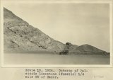
15
Outcrop of Paleozoic limestone (fossils) 1/4 mile SW of Baker
P0013 Herbert E. Gregory Photograph Collection
P0013n08_183_1700
16
Searles Lake, California. Columns of tufa south end of Searles Lake
P0013 Herbert E. Gregory Photograph Collection
P0013n08_193_1720
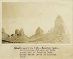
17
Searles Lake, California. Columns of tufa south end of Searles Lake. Marks water level of ancient lake
P0013 Herbert E. Gregory Photograph Collection
P0013n08_193_1721
18
West end Wingate Pass looking into Panamint Valley
P0013 Herbert E. Gregory Photograph Collection
P0013n09_013_1746
19
Paleozoic section north of Wingate Pass
P0013 Herbert E. Gregory Photograph Collection
P0013n09_023_1764
20
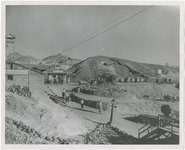
Monorail. Wingate Pass
P0013 Herbert E. Gregory Photograph Collection
P0013n09_027_1772
21
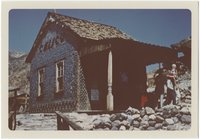
Calico, California [01]
P0244 Olive Woolley Burt Photograph Collection
P0244add1n3_02_0781
22
Calico, California [02]
P0244 Olive Woolley Burt Photograph Collection
P0244add1n3_02_0782
23
Calico, California [03]
P0244 Olive Woolley Burt Photograph Collection
P0244add1n3_02_0783
24
Calico, California [04]
P0244 Olive Woolley Burt Photograph Collection
P0244add1n3_02_0784
25
Calico, California [05]
P0244 Olive Woolley Burt Photograph Collection
P0244add1n3_02_0785
1
-
25
of
41
<
1
2
>