|
|
Title | Collection Number And Name | Photo Number |
| 51 |
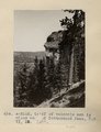 | Cliff of volcanic ash 1 1/2 miles west of Cottonwood Pass, NM. VI, 35. 1911 (Photo N-M112) | P0013 Herbert E. Gregory Photograph Collection | P0013n05_14_0693 |
| 52 |
 | Cottonwood Pass (Bes-lici-bigiz). Ash cliff on south side of stream. Intrusive diabase on north. 1911 (Photo G-208) | P0013 Herbert E. Gregory Photograph Collection | P0013n05_15_0694 |
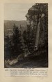
| 53 |
 | Cottonwood Pass. Extreme crest, west slope. Mrs. Gregory, photo. 1911 (Photo G209) | P0013 Herbert E. Gregory Photograph Collection | P0013n05_15_0695 |
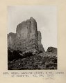
| 54 |
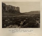
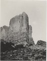 | LaPlata cliff, 6 mi. south of Moore's. VI, 38. 1911 (Photo G210) | P0013 Herbert E. Gregory Photograph Collection | P0013n05_16_0697 |
| 55 |
 | LaPlata cliff, 6 mi. south of Moore's. VI, 38. 1911 (Photo G210) | P0013 Herbert E. Gregory Photograph Collection | P0013n05_16_0697 |
| 56 |
 | LaPlata cliff, 6 mi. south of Moore's. VI, 38. 1911 (Photo G211) | P0013 Herbert E. Gregory Photograph Collection | P0013n05_17_0698 |
| 57 |
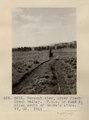 | General view, upper Black Creek valley. H.E.G. on road 5± miles south of Moore's store. VI, 35. 1911 (Photo G212) | P0013 Herbert E. Gregory Photograph Collection | P0013n05_17_0699 |
| 58 |
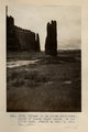
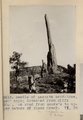 | Needle of LaPlata sandstone, 150' high; detached from cliff 300'. On road from Moore's to upper waters of Black Creek. VI, 38 (Photo G213) | P0013 Herbert E. Gregory Photograph Collection | P0013n05_18_0700 |
| 59 |
 | Another view of Photo G213. VI, 38 (Photo G213A) | P0013 Herbert E. Gregory Photograph Collection | P0013n05_18_0701 |
| 60 |
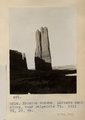 | Erosion column, LaPlata sandstone, near Baigaiche Mt. 1911. VI, 39, 45 (Photo G214) | P0013 Herbert E. Gregory Photograph Collection | P0013n05_18_0702 |
| 61 |
 | Camp at base of Baigaiche Mt. VI, 45. 1911 (Photo N-M113) | P0013 Herbert E. Gregory Photograph Collection | P0013n05_19_0703 |
| 62 |
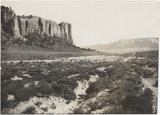 | LaPlata cliffs 6± mi. south of Crystal, NM. Heald, photo. 1911 | P0013 Herbert E. Gregory Photograph Collection | P0013n05_20_0705 |
| 63 |
 | LaPlata cliffs 6± mi. south of Crystal, NM. Heald, photo. 1911 | P0013 Herbert E. Gregory Photograph Collection | P0013n05_20_0705 |
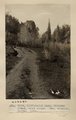
| 64 |
 | Red lake, north of Fort Defiance, looking south. Volcanic neck at base of lake in background. Heald, photo. 1911 (Photo G216) | P0013 Herbert E. Gregory Photograph Collection | P0013n05_21_0706 |
| 65 |
 | Column in La Plata sandstone, mouth of Black Creek canon, in Todilto Park. Heald or Mrs. G, photo. 1911 (Photo G217) | P0013 Herbert E. Gregory Photograph Collection | P0013n05_22_0707 |
| 66 |
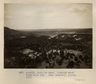 | Todilto park, looking west from east rim. Mrs. Gregory, photo. 1911 (Photo N-M115) | P0013 Herbert E. Gregory Photograph Collection | P0013n05_23_0708 |
| 67 |
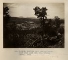 | Todilto park looking northwest from east rim. Mrs. Gregory, photo. 1911 (Photo N-M116) | P0013 Herbert E. Gregory Photograph Collection | P0013n05_24_0709 |
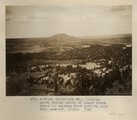
| 68 |
 | Todilto park, looking south. Defiance Mesas in skyline. Heald, photo. 1911 (Photo N-M117) | P0013 Herbert E. Gregory Photograph Collection | P0013n05_25_0710 |
| 69 |
 | Baigaiche Mt., looking south across mouth of Black creek where it emerges from Todilto Park. Mrs. Gregory, photo. 1911 (Photo N-M118) | P0013 Herbert E. Gregory Photograph Collection | P0013n05_26_0711 |
| 70 |
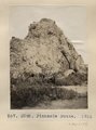 | Pinnacle Butte. 1911 (Photo G292) | P0013 Herbert E. Gregory Photograph Collection | P0013n05_78_0801 |
| 71 |
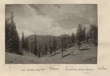 | Washington Pass, Lukachukai Mts | P0013 Herbert E. Gregory Photograph Collection | P0013n05_78verso_0802 |
| 72 |
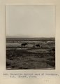 | Manuelito Springs east of Tohatchie, N.M. Shaler, photo | P0013 Herbert E. Gregory Photograph Collection | P0013n05_85_0813 |
| 73 |
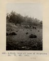
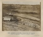 | Sheep Dip of Pueblo Bonito agency. Heald, photo. 1911 (Photo N-M132 & N-M132a) | P0013 Herbert E. Gregory Photograph Collection | P0013n05_86_0814 |
| 74 |
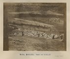 | Same as Photo N-M132 (Photo N-M132a) | P0013 Herbert E. Gregory Photograph Collection | P0013n05_87_0815 |
| 75 |
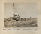 | Oil wells, Seven Lakes. 1911 (Photo G300) | P0013 Herbert E. Gregory Photograph Collection | P0013n05_88_0816 |