Home
Browse
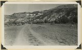
Ask Us
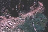
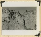
Chat
Harmful Language Statement
Log in
Photo Archives
Advanced Search
About
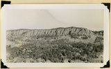
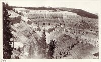
Over 70,000 photos covering a variety of topics from Marriott Library Special Collections
Year
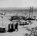
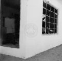
1853
1854
1855
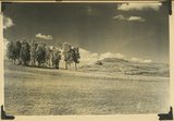
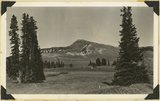
1856
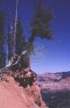
1857
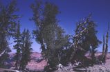
1858
1859
1860
1861
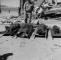
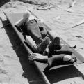
1862
1863
1864
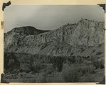
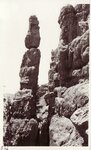
1865
1866
1867
1868
1869
1870
1871
1872
1873
1874
1875
1876
1877
1878
1879
1880
1881
1882
1883
1884
1885
1886
1887
1888
1889
1890
1891
1892
1893
1894
1895
1896
1897
1898
1899
1900
1901
1902
1903
1904
1905
1906
1907
1908
1909
1910
1911
1912
1913
1914
1915
1916
1917
1918
1919
1920
1921
1922
1923
1924
1925
1926
1927
1928
1929
1930
1931
1932
1933
1934
1935
1936
1937
1938
1939
1940
1941
1942
1943
1944
1945
1946
1947
1948
1949
1950
1951
1952
1953
1954
1955
1956
1957
1958
1959
1960
1961
1962
1963
1964
1965
1966
1967
1968
1969
1970
1971
1972
1973
1974
1975
1976
1977
1978
1979
1980
1981
1982
1983
1984
1985
1986
1987
1988
1989
1990
TO
1853
1854
1855
1856
1857
1858
1859
1860
1861
1862
1863
1864
1865
1866
1867
1868
1869
1870
1871
1872
1873
1874
1875
1876
1877
1878
1879
1880
1881
1882
1883
1884
1885
1886
1887
1888
1889
1890
1891
1892
1893
1894
1895
1896
1897
1898
1899
1900
1901
1902
1903
1904
1905
1906
1907
1908
1909
1910
1911
1912
1913
1914
1915
1916
1917
1918
1919
1920
1921
1922
1923
1924
1925
1926
1927
1928
1929
1930
1931
1932
1933
1934
1935
1936
1937
1938
1939
1940
1941
1942
1943
1944
1945
1946
1947
1948
1949
1950
1951
1952
1953
1954
1955
1956
1957
1958
1959
1960
1961
1962
1963
1964
1965
1966
1967
1968
1969
1970
1971
1972
1973
1974
1975
1976
1977
1978
1979
1980
1981
1982
1983
1984
1985
1986
1987
1988
1989
1990
Type
Image
161
Image/StillImage
71
Format
image/jpeg
216
application/pdf
25
Collection Name
Herbert E. Gregory
109
Frederick J. Pack
48
Joseph Kingsbury
19
John Stockert
14
Olive Woolley Burt
12
Howard D. Johnson
10
John Esplin
9
Wasatch Mountain Club
8
Utah Flood Survey
4
Rocky Mountain Power Company
3
Utah Humanities Research Foundation
3
Emigration Canyon History
1
Western and Mormon stereograph collection
1
More
Filters:
Collection:
"uum_map"
Spatial Coverage:
"Iron County (Utah)"
1
-
25
of
241
<
1
2
3
4
5
6
7
8
9
10
>
Gallery view
Number of results to display per page
10
25
50
100
200
Sort by Relevance
Sort by Title A-Z
Sort by Title Z-A
Sort by Date Ascending
Sort by Date Descending
Sort by Last Modified Ascending
Sort by Last Modified Descending
Sort by Photo Number
Title
Collection Number And Name
Photo Number
1
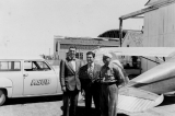
"Covering A-bomb explosion. Art - Frank & Royce." (Johnson covered this open-air test in Nevada for radio station KSUB of Cedar City, Utah.)
P0499 Howard D. Johnson Photograph Collection
P0499n18
2
"Pryor Knoll, eroded basaltic cone and lava flows over Cretaceous rocks. View looking northwest. Western edge of Kolob Terrace. Just back of the yellow pines are the cliffs at the head of the westward flowing Shurtz Creek. Iron County, UT, 1942
P0013 Herbert E. Gregory Photograph Collection
P0013n11_190_2831
3
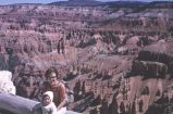
Along two-mile trail at Cedar Breaks
P1100 John Stockert Photograph Collection
p1100n079
4
Along two-mile trail at Cedar Breaks
P1100 John Stockert Photograph Collection
p1100n078
5
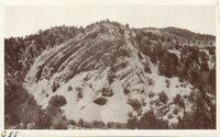
Anticline, Faulted - Cedar Canyon
P0268 Frederick J. Pack photograph collection
P0268n01_13_681
6
Arrangement of formations at Squaw Canyon along the line of the Kanarra fold. Triassic; Navajo upper Jurassic (Carmel, Entrada, Curtis, Winsor); Cretaceous. Steep dips of lower formations progressively flatten eastward (right). Iron County, UT, 1942
P0013 Herbert E. Gregory Photograph Collection
P0013n11_188_2828
7
At saddle along two-mile trail, Cedar Breaks
P1100 John Stockert Photograph Collection
p1100n071
8
Basalt flow from Horsetail Mountain near its termination (eastward; right), Iron County, UT, 1942
P0013 Herbert E. Gregory Photograph Collection
P0013n11_184_2822
9
Black Ledge. Cliff of rhyolite that for about 20 miles forms the rim of the Markagunt Plateau. The escarpment is the upthrown side of a fault concealed by the talus. Hoosier Lake, Iron County, UT, 1942
P0013 Herbert E. Gregory Photograph Collection
P0013n11_181_2816
10
Black Mountain culminating in Richardson Peak (altitude 9900 feet), viewed from southwest. Eroded crater and extensive basaltic flows overlying Cretaceous and Tertiary sediments. View looking north east edge of Kolob Terrace. Iron County, UT, 1942
P0013 Herbert E. Gregory Photograph Collection
P0013n11_189_2830
11
Blast damage overview. (Johnson covered this open-air test in Nevada for radio station KSUB of Cedar City, Utah.)
P0499 Howard D. Johnson Photograph Collection
P0499n17
12
Blast damage to building. (Johnson covered this open-air test in Nevada for radio station KSUB of Cedar City, Utah.)
P0499 Howard D. Johnson Photograph Collection
P0499n10
13
Braffit Point. Mass of conglomerate in the Kaiparowits formation, branch of Parowan Canyon, Iron County, UT, 1942
P0013 Herbert E. Gregory Photograph Collection
P0013n11_178_2811
14
Brian Head, volcanic mass from the north rim of Cedar Breaks, Iron County, Utah, 1937.
P0013 Herbert E. Gregory Photograph Collection
P0013n10_208_2464
15
Bristlecone pine on edge, Cedar Breaks
P1100 John Stockert Photograph Collection
p1100n072
16
Bristlecone pines along two-mile trail at Cedar Breaks
P1100 John Stockert Photograph Collection
p1100n074
17
Bryce Canyon and Mount Carmel Highway dedication, Zion National Park, 1930 [32]
P0004 Wasatch Mountain Club Photograph Collection
P0004n06_15_032
18
Carmel formation. Coal Canyon, Iron County, UT. 1942
P0013 Herbert E. Gregory Photograph Collection
P0013n11_179_2813
19
Carmel formation. Coal Canyon, Iron County, UT. 1942
P0013 Herbert E. Gregory Photograph Collection
P0013n11_179_2812
20
Casualties (dummies). (Johnson covered this open-air test in Nevada for radio station KSUB of Cedar City, Utah.)
P0499 Howard D. Johnson Photograph Collection
P0499n15
21
Casualties (dummies). (Johnson covered this open-air test in Nevada for radio station KSUB of Cedar City, Utah.)
P0499 Howard D. Johnson Photograph Collection
P0499n14
22
Casualties (dummies). (Johnson covered this open-air test in Nevada for radio station KSUB of Cedar City, Utah.)
P0499 Howard D. Johnson Photograph Collection
P0499n16
23
Cedar Breaks
P0268 Frederick J. Pack photograph collection
P0268n01_13_654
24
Cedar Breaks
P0268 Frederick J. Pack photograph collection
P0268n01_13_668
25
Cedar Breaks
P0268 Frederick J. Pack photograph collection
P0268n01_13_667
1
-
25
of
241
<
1
2
3
4
5
6
7
8
9
10
>