Home
Browse
Ask Us
Chat
Harmful Language Statement
Log in
Photo Archives
Advanced Search
About
Over 70,000 photos covering a variety of topics from Marriott Library Special Collections
Year
1915
1916
1917
1918
1919
1920
1921
1922
1923
1924
1925
1926
1927
1928
1929
1930
1931
1932
1933
1934
1935
1936
1937
1938
1939
1940
1941
1942
1943
1944
1945
1946
1947
1948
1949
1950
1951
1952
1953
1954
1955
1956
1957
1958
1959
1960
1961
1962
1963
1964
1965
1966
1967
1968
1969
1970
1971
1972
1973
1974
1975
1976
1977
1978
1979
1980
1981
1982
1983
1984
1985
TO
1915
1916
1917
1918
1919
1920
1921
1922
1923
1924
1925
1926
1927
1928
1929
1930
1931
1932
1933
1934
1935
1936
1937
1938
1939
1940
1941
1942
1943
1944
1945
1946
1947
1948
1949
1950
1951
1952
1953
1954
1955
1956
1957
1958
1959
1960
1961
1962
1963
1964
1965
1966
1967
1968
1969
1970
1971
1972
1973
1974
1975
1976
1977
1978
1979
1980
1981
1982
1983
1984
1985
Type
Image
271
Image/StillImage
12
Format
image/jpeg
304
application/pdf
18
Collection Name
Herbert E. Gregory
199
Wasatch Mountain Club
39
John Stockert
21
Everett Ruess Family
18
Lowry Nelson
18
Charles Kelly
7
Elbert M. Dansie
7
Lyman P. Hunter
6
Bridges
2
Frederick J. Pack
2
Clifford Evans
1
Gibb R. Madsen
1
Utah Flood Survey
1
More
Filters:
Collection:
"uum_map"
Spatial Coverage:
"Garfield County (Utah)"
201
-
225
of
322
<
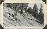
4
5
6
7
8
9
10
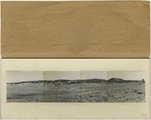
11
12
13
>
Gallery view
Number of results to display per page
10
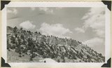
25
50
100
200
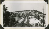
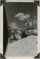
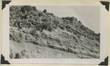
Sort by Relevance
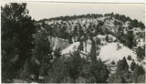
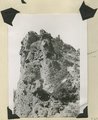
Sort by Title A-Z
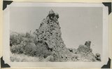
Sort by Title Z-A
Sort by Date Ascending
Sort by Date Descending
Sort by Last Modified Ascending
Sort by Last Modified Descending
Sort by Photo Number
Title
Collection Number And Name
Photo Number
201
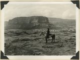
Surface of Navajo sandstone between Escalante Canyon and Kaiparowits Plateau. Butte of Upper Jurassic rocks. Near head of Davis Creek. Garfield County, UT, 1944
P0013 Herbert E. Gregory Photograph Collection
P0013n12_062_2919
202
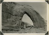
Gothic Arch. Width 174 feet, estimated height 190 feet. End of a buttress of Navajo sandstone resting on Kayenta. Soda Creek branch of Escalante River. Garfield County, UT, 1944
P0013 Herbert E. Gregory Photograph Collection
P0013n12_063_2920
203
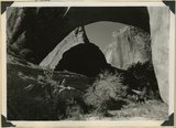
Natural bridge of Navajo sandstone. Span 85 feet, height to girder 76 feet. Willow Creek. Garfield County, UT, 1944
P0013 Herbert E. Gregory Photograph Collection
P0013n12_064_2921
204
Natural bridge of Navajo sandstone. Span 85 feet, height to girder 76 feet. Willow Creek. Garfield County, UT, 1944
P0013 Herbert E. Gregory Photograph Collection
P0013n12_064_2922
205
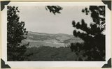
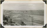
Looking west across Panguitch. Sevier River formation (foreground), alluvium (middle distance), basalt (left center), and pyroclastic slopes leading to Little Creek Peak (background), on the east wall of Bear Valley. Garfield County, UT, 1944
P0013 Herbert E. Gregory Photograph Collection
P0013n12_065_2923
206
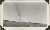
Looking northwest across Horse Lake Valley. Basalt (foreground), Pyroclastics (background). Garfield County, UT, 1944
P0013 Herbert E. Gregory Photograph Collection
P0013n12_066_2924
207
Treeless slope developed on pyroclastic and igneous rocks typical of areas west of Panguitch Creek. Garfield County, UT, 1944
P0013 Herbert E. Gregory Photograph Collection
P0013n12_066_2925
208
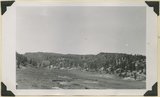
South Fork of Sevier River below mouth of Asay Creek. Garfield County, UT, 1944
P0013 Herbert E. Gregory Photograph Collection
P0013n12_067_2926
209
Lower Castle Creek Valley; broad floor of low gradient developed in Brian Head formation. Garfield County, UT, 1944
P0013 Herbert E. Gregory Photograph Collection
P0013n12_067_2927
210
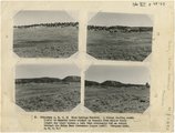
(Panorama A, B, C, D) Blue Springs Meadows. A stream leading south (left) to Mammoth Creek blocked by basalts from Miller Knoll (right sky line) became a lake that eventuallly cut an outlet through the Brian Head formation (upper left).
P0013 Herbert E. Gregory Photograph Collection
P0013n12_068-069_2929ABCD
211
Panorama--4 photographs. Blue Springs meadows. A former valley leading to Mammoth Creek blocked by basalts from Miller Knoll (right skyline) became a lake that eventually cut an outlet northward through the Brian Head formation (upper left). Garfield County, UT, 1944
P0013 Herbert E. Gregory Photograph Collection
P0013n12_068-069_pan
212
Blue Springs meadow at Leigh ranch. Stream from big springs (lower left) meanders across an ancient lake bed and escapes through a water gap (center distance). Garfield County, UT, 1944
P0013 Herbert E. Gregory Photograph Collection
P0013n12_068_2928
213
Panorama (a): Blue Springs meadows. A former valley leading to Mammoth Creek blocked by basalts from Miller Knoll (right skyline) became a lake that eventually cut an outlet northward through the Brian Head formation (upper left). Garfield County, UT, 1944
P0013 Herbert E. Gregory Photograph Collection
P0013n12_068_2929A
214
Panorama (b): Blue Springs meadows. A former valley leading to Mammoth Creek blocked by basalts from Miller Knoll (right skyline) became a lake that eventually cut an outlet northward through the Brian Head formation (upper left). Garfield County, UT, 1944
P0013 Herbert E. Gregory Photograph Collection
P0013n12_069_2929B
215
Panorama (c): Blue Springs meadows. A former valley leading to Mammoth Creek blocked by basalts from Miller Knoll (right skyline) became a lake that eventually cut an outlet northward through the Brian Head formation (upper left). Garfield County, UT, 1944
P0013 Herbert E. Gregory Photograph Collection
P0013n12_069_2929C
216
Panorama (d): Blue Springs meadows. A former valley leading to Mammoth Creek blocked by basalts from Miller Knoll (right skyline) became a lake that eventually cut an outlet northward through the Brian Head formation (upper left). Garfield County, UT, 1944
P0013 Herbert E. Gregory Photograph Collection
P0013n12_069_2929D
217
Sheep Flat. Broad treeless highland crossed by shallow stream runways between Coalpits Wash and Pinion Ridge. A little modified part of the eastward dipping (right) surface of Markagunt Plateau. Garfield County, UT, 1944
P0013 Herbert E. Gregory Photograph Collection
P0013n12_070_2930
218
Brian Head formation underlain by pink Wasatch limestone on Highway 89, 2± miles north of Castle Creek. Garfield County, UT, 1944
P0013 Herbert E. Gregory Photograph Collection
P0013n12_072_2934
219
Brian Head formation, branch of Asay Creek; lies beneath basalt flows. Garfield County, UT, 1944
P0013 Herbert E. Gregory Photograph Collection
P0013n12_072_2935
220
Brian Head formation, branch of Asay Creek; lies beneath basalt flows. Garfield County, UT, 1944
P0013 Herbert E. Gregory Photograph Collection
P0013n12_072_2935
221
Typical outcrop of conglomerate near base of Brian Head formation, Castle Creek. Garfield County, UT, 1944
P0013 Herbert E. Gregory Photograph Collection
P0013n12_073_2936
222
Brian Head formation at the 'Castles,' Castle Creek. Garfield County, UT, 1944
P0013 Herbert E. Gregory Photograph Collection
P0013n12_073_2937
223
Brian Head formation at the 'Castles,' Castle Creek. Garfield County, UT, 1944. Details of erosion
P0013 Herbert E. Gregory Photograph Collection
P0013n12_074_2938
224
Igneous breccia in Brian Head formation(?), upper Panguitch Creek. Garfield County, UT, 1944
P0013 Herbert E. Gregory Photograph Collection
P0013n12_074_2939
225
Sevier River formation overlaid by basalt near mouth of Corral Creek on highway 89. Garfield County, Utah, 1944
P0013 Herbert E. Gregory Photograph Collection
P0013n12_075_2940
201
-
225
of
322
<
4
5
6
7
8
9
10
11
12
13
>