Home
Browse
Ask Us
Chat
Harmful Language Statement
Log in
Photo Archives
Advanced Search
About
Over 70,000 photos covering a variety of topics from Marriott Library Special Collections
Year
1915
1916
1917
1918
1919
1920
1921
1922
1923
1924
1925
1926
1927
1928
1929
1930
1931
1932
1933
1934
1935
1936
1937
1938
1939
1940
1941
1942
1943
1944
1945
1946
1947
1948
1949
1950
1951
1952
1953
1954
1955
1956
1957
1958
1959
1960
1961
1962
1963
1964
1965
1966
1967
1968
1969
1970
1971
1972
1973
1974
1975
1976
1977
1978
1979
1980
1981
1982
1983
1984
1985
TO
1915
1916
1917
1918
1919
1920
1921
1922
1923
1924
1925
1926
1927
1928
1929
1930
1931
1932
1933
1934
1935
1936
1937
1938
1939
1940
1941
1942
1943
1944
1945
1946
1947
1948
1949
1950
1951
1952
1953
1954
1955
1956
1957
1958
1959
1960
1961
1962
1963
1964
1965
1966
1967
1968
1969
1970
1971
1972
1973
1974
1975
1976
1977
1978
1979
1980
1981
1982
1983
1984
1985
Type
Image
271
Image/StillImage
12
Format
image/jpeg
304
application/pdf
18
Collection Name
Herbert E. Gregory
199
Wasatch Mountain Club
39
John Stockert
21
Everett Ruess Family
18
Lowry Nelson
18
Charles Kelly
7
Elbert M. Dansie
7
Lyman P. Hunter
6
Bridges
2
Frederick J. Pack
2
Clifford Evans
1
Gibb R. Madsen
1
Utah Flood Survey
1
More
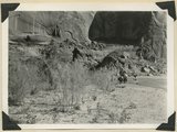
Filters:
Collection:
"uum_map"
Spatial Coverage:
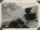
"Garfield County (Utah)"
176
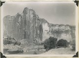
-
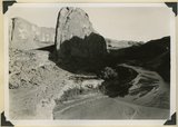
200
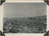
of
322
<
3
4
5
6
7
8
9
10
11
12
>
Gallery view
Number of results to display per page
10
25
50
100
200
Sort by Relevance
Sort by Title A-Z
Sort by Title Z-A
Sort by Date Ascending
Sort by Date Descending
Sort by Last Modified Ascending
Sort by Last Modified Descending
Sort by Photo Number
Title
Collection Number And Name
Photo Number
176
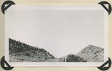
Burro Gap on East Fork of Sevier River above mouth of Deer Creek. Locus of Paunsaugunt fault; upthrow on east right. Garfield County, UT. 1943
P0013 Herbert E. Gregory Photograph Collection
P0013n12_015_2862
177
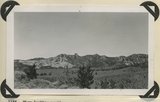
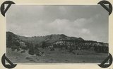
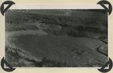
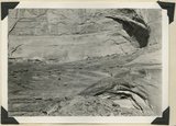
View looking north across Casto Canyon toward the face of the Sevier Plateau. Slope of Brian Head formation beneath gravels (foreground) and in steep white slope ( middle distance) is capped by igneous conglomerates and lavas. Garfield County, UT. 1943
P0013 Herbert E. Gregory Photograph Collection
P0013n12_015_2863
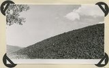
178
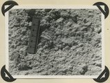
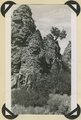
Detailed view of pumice conglomerate in the Brian Head formation, Casto Bluff, Garfield County, UT, 1943
P0013 Herbert E. Gregory Photograph Collection
P0013n12_017_2864
179
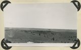
Surface of Markagunt Plateau looking west from the head of Deedy Hollow. Coated with gravel from decomposed igneous conglomerates and rhyolite. Garfield County, UT. 1943
P0013 Herbert E. Gregory Photograph Collection
P0013n12_017_2865
180
Upper Brian Head formation near the mouth of Deedy Hollow. Garfield County, UT. 1943
P0013 Herbert E. Gregory Photograph Collection
P0013n12_018_2866
181
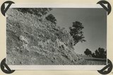
Little valleys near head of Pole Creek. Lower Brian Head formation capped by decomposed igneous conglomerate. Garfield County, UT. 1943
P0013 Herbert E. Gregory Photograph Collection
P0013n12_019_2867
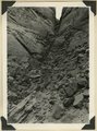
182
Brian Head formation in the walls of Panguitch Canyon near power house. Garfield County, UT. 1943
P0013 Herbert E. Gregory Photograph Collection
P0013n12_019_2868
183
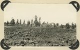
Surface of recent basalt flow north of Duck Creek sinks. Garfield County, UT. 1943
P0013 Herbert E. Gregory Photograph Collection
P0013n12_020_2869
184
South sink of Duck Creek. Entire stream enters hole in Wasatch limestone. Garfield County, UT. 1943
P0013 Herbert E. Gregory Photograph Collection
P0013n12_021_2870
185
End of recent basalt flow at the race track, Panguitch Lake. Garfield County, UT, 1943
P0013 Herbert E. Gregory Photograph Collection
P0013n12_021_2871
186
West entrance to Hole-in-the-Rock, an eroded fault crack in Navajo sandstone on the west rim of Glen Canyon. A feature of the abandoned Escalante-Bluff Road. Garfield County, UT, 1944
P0013 Herbert E. Gregory Photograph Collection
P0013n12_054_2904
187
West entrance to Hole-in-the-Rock, an eroded fault crack in Navajo sandstone on the west rim of Glen Canyon. A feature of the abandoned Escalante-Bluff Road. Garfield County, UT, 1944
P0013 Herbert E. Gregory Photograph Collection
P0013n12_054_2905
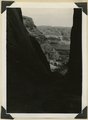
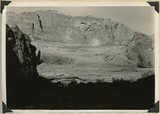
188
Looking east across Glen Canyon from east entrance to Hole-in-the-Rock. Navajo sandstone (foreground and skyline), below it Kayenta and Wingate. Garfield County, UT, 1944
P0013 Herbert E. Gregory Photograph Collection
P0013n12_055_2906
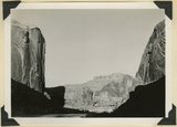
189
Head of Break Neck Trail down the south wall of Escalante Canyon (middle distance). Navajo sandstone. Garfield County, UT, 1944
P0013 Herbert E. Gregory Photograph Collection
P0013n12_055_2907
190
Escalante Canyon 2 miles below Big Bend. Walls of Navajo sandstone 800 feet high. Garfield, UT, 1944
P0013 Herbert E. Gregory Photograph Collection
P0013n12_056_2908
191
Escalante Canyon down stream from Big Bend. Garfield County, UT, 1944
P0013 Herbert E. Gregory Photograph Collection
P0013n12_056_2909
192
Escalante Canyon, cliff cave 3 miles above Cave Camp. Garfield County, UT, 1944
P0013 Herbert E. Gregory Photograph Collection
P0013n12_057_2910
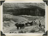
193
Escalante Canyon. Pueblo ruins in cliff cave. Navajo sandstone. Scale shown by horse. Garfield County, UT, 1944
P0013 Herbert E. Gregory Photograph Collection
P0013n12_057_2911
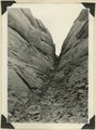
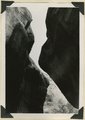
194
Willow Creek branch of Escalante Canyon. Entrance to 'the Narrows,' 400 feet long and 5-6 feet wide; perched log marks high water stage. Garfield County, UT, 1944
P0013 Herbert E. Gregory Photograph Collection
P0013n12_058_2912
195
Willow Creek branch of Escalante Canyon. In sinking its channel the creek has been guided by joints in Navajo sandstone. Garfield County, UT, 1944
P0013 Herbert E. Gregory Photograph Collection
P0013n12_058_2913
196
Escalante Canyon. Sheer wall of Navajo sandstone 840 feet high. Garfield County, UT, 1944
P0013 Herbert E. Gregory Photograph Collection
P0013n12_059_2914
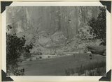
197
Escalante Canyon walls of Navajo sandstone at Big Bend camp. Moonlight view. Garfield County, UT, 1944
P0013 Herbert E. Gregory Photograph Collection
P0013n12_059_2915
198
Escalante River at Big Bend, flowing west. After surrounding the tower of Navajo sandstone (center), the river comes within 300 feet of its east flowing section at the base of the wall (upper left). Garfield County, UT, 1944
P0013 Herbert E. Gregory Photograph Collection
P0013n12_060_2916
199
Escalante River at Big Bend, flowing east. At times of high water the stream flows across Kayenta formation at the meander neck (lower right). Garfield County, UT, 1944
P0013 Herbert E. Gregory Photograph Collection
P0013n12_061_2917
200
Surface of Navajo sandstone trenched by Escalante Canyon (right middle). Aquarius Plateau on skyline. Garfield County, UT, 1944
P0013 Herbert E. Gregory Photograph Collection
P0013n12_062_2918
176
-
200
of
322
<
3
4
5
6
7
8
9
10
11
12
>