|
|
Title | Collection Number And Name | Photo Number |
| 151 |
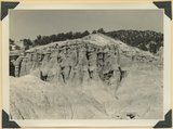 |
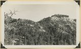
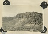
Post-Wasatch Sevier(?) formation, upper part) green sandstone in columns, white, cherty limestone and lava(top) | P0013 Herbert E. Gregory Photograph Collection | P0013n11_133_2723 |
| 152 |
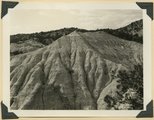 |
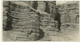
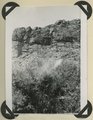
Post-Wasatch Sevier(?) formation, lower part: erosion features of clays and silts | P0013 Herbert E. Gregory Photograph Collection | P0013n11_133_2724 |
| 153 |
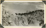 |
Post-Wasatch Sevier(?) formation, lower part: erosion features of clays and silts | P0013 Herbert E. Gregory Photograph Collection | P0013n11_134_2725 |
| 154 |
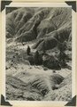 |
Post-Wasatch Sevier(?) formation, lower part: erosion features of clays and silts | P0013 Herbert E. Gregory Photograph Collection | P0013n11_134_2726 |
| 155 |
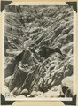 |
Post-Wasatch Sevier(?) formation, lower part: erosion features of clays and silts | P0013 Herbert E. Gregory Photograph Collection | P0013n11_135_2727 |
| 156 |
 |
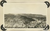
Valley East Fork Sevier River below mouth of Podunk Creek, Garfield County, UT | P0013 Herbert E. Gregory Photograph Collection | P0013n11_147_2750 |
| 157 |
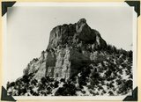 |
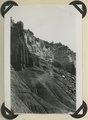
Casto Bluff head of Casto Canyon southwest edge of Sevier Plateau. Acidic lava underlain by Sevier(?) formation, Garfield County, UT, 1941 | P0013 Herbert E. Gregory Photograph Collection | P0013n11_148_2751 |
| 158 |
 |
Same as 2751, shows eroded top of Sevier Plateau | P0013 Herbert E. Gregory Photograph Collection | P0013n11_148_2752 |
| 159 |
 |
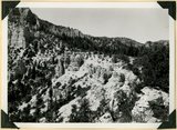
Castro Bluff, detail thin beds (upper) in Sevier(?) formation | P0013 Herbert E. Gregory Photograph Collection | P0013n11_149_2753 |
| 160 |
 |
Casto Bluff, detail thick lava beds in Sevier(?) formation | P0013 Herbert E. Gregory Photograph Collection | P0013n11_149_2754 |
| 161 |
 |
Castro Bluff, detail pumice conglomerate in Sevier formation | P0013 Herbert E. Gregory Photograph Collection | P0013n11_150_2755 |
| 162 |
 |
Castro Bluff, view looking westward from its base. Terrace developed in the Sevier(?) formation at the top of the Wasatch formation | P0013 Herbert E. Gregory Photograph Collection | P0013n11_150_2756 |
| 163 |
 |
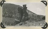
Sevier fault, mouth of Red Canyon. Wasatch right), basalt (left and top). Garfield County, UT. 1942 | P0013 Herbert E. Gregory Photograph Collection | P0013n11_186_2824 |
| 164 |
 |
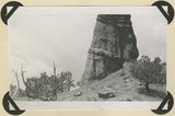
Brian Head formation capped by lava. Branch of Limekiln Canyon. Garfield County, UT. 1942 | P0013 Herbert E. Gregory Photograph Collection | P0013n11_187_2825 |
| 165 |
 |
Herbert E. Gregory Book 12: Colorado Plateau, Province, 1942-1944 | P0013 Herbert E. Gregory Photograph Collection | P0013n12 |
| 166 |
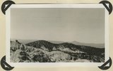 |
Erosion surface developed on Brian Head formation; downthrow side of Sevier fault. Rim of Sevier Plateau on skyline. Limekiln Gulch, Garfield County, UT, 1942 | P0013 Herbert E. Gregory Photograph Collection | P0013n12_004_2851 |
| 167 |
 |
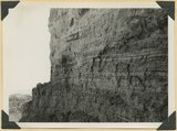
Cretaceous shales (tropic formation). Antimony Canyon, Garfield County, UT. 1943 | P0013 Herbert E. Gregory Photograph Collection | P0013n12_010_2854A |
| 168 |
 |
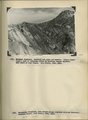
View looking northeast across Antimony Canyon. Cretaceous strata (foreground and middle distance) below igneous conglomerate and acidic lavas that form the surface of Aquarius Plateau. Garfield County, UT, 1943 | P0013 Herbert E. Gregory Photograph Collection | P0013n12_010_2855 |
| 169 |
 |
Entrada sandstone, regular bedded shaly phase overlain by undifferentiated Curtis and Winsor formations. Antimony Canyon, Garfield County, UT, 1943 | P0013 Herbert E. Gregory Photograph Collection | P0013n12_011_2856 |
| 170 |
 |
Erosion features in Entrada sandstone. Antimony Canyon, Garfield County, UT, 1943 | P0013 Herbert E. Gregory Photograph Collection | P0013n12_011_2857 |
| 171 |
 |
Erosion features in Entrada sandstone. Antimony Canyon, Garfield County, UT, 1943 | P0013 Herbert E. Gregory Photograph Collection | P0013n12_012_2858 |
| 172 |
 |
Brian Head formation capped by lava (rhyolite?): Cliff on upthrown side of Paunsaugunt fault. East fork of Sevier River near the mouth of Deer Creek. Garfield County, UT. 1943 | P0013 Herbert E. Gregory Photograph Collection | P0013n12_012_2859 |
| 173 |
 |
Detailed view of pumice conglomerate in the Brian Head formation, Casto Bluff, Garfield County, UT, 1943 | P0013 Herbert E. Gregory Photograph Collection | P0013n12_013_2860 |
| 174 |
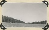 |
Glaciated surface showing (roche mountain): glade in spruce forest at top of Aquarius Plateau at altitude of 10,800 feet. Near the head of Antimony Creek, Garfield County, UT, 1943 | P0013 Herbert E. Gregory Photograph Collection | P0013n12_014_2861_1 |
| 175 |
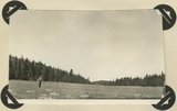 |
Glaciated surface showing (roche mountain): glade in spruce forest at top of Aquarius Plateau at altitude of 10,800 feet. Near the head of Antimony Creek, Garfield County, UT, 1943 | P0013 Herbert E. Gregory Photograph Collection | P0013n12_014_2861_2 |