|
|
Title | Collection Number And Name | Photo Number |
| 126 |
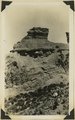 |
Coal beds just above Morrison Dakota contact (in shadow) 2± miles north of Cannonville, Utah, 1932. | P0013 Herbert E. Gregory Photograph Collection | P0013n10_113_2278 |
| 127 |
 |
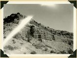
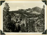
Surface of Paunsaugunt Plateau developed in Wasatch limestone, near head of Red Canyon looking west to highlands along Sevier fault. Garfield County, Utah, 1934. | P0013 Herbert E. Gregory Photograph Collection | P0013n10_129_2306 |
| 128 |
 |
Paunsaugunt Plateau developed in Wasatch limestone, near head of Red Canyon looking north toward volcanic mesas. Garfield County, Utah, 1934. | P0013 Herbert E. Gregory Photograph Collection | P0013n10_130_2307 |
| 129 |
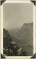 |
Shonesburg Gulch, branch of Parunumeap Canyon, Line Fold trail, Rockville to Mt. Carmel. Navajo sandstone underlaid by Kyenta and Chinle. Washington County, Utah, 1935. | P0013 Herbert E. Gregory Photograph Collection | P0013n10_130_2308 |
| 130 |
 |
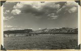
Looking east across Sevier River near Hatch River terraces in middle distance, "Pink Cliffs" (Wasatch) in background bounded by Sevier fault. Garfield County, Utah, 1936. | P0013 Herbert E. Gregory Photograph Collection | P0013n10_147_2341 |
| 131 |
 |
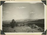
Table Cliff Plateau, looking northeast from Bryce Point. Paria River and town of Tropic in middle distance. Bryce National Park, Utah, 1935. | P0013 Herbert E. Gregory Photograph Collection | P0013n10_207_2461 |
| 132 |
 |
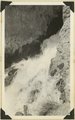
Source of the Virgin River. Looking northwest along Cascade Falls Trail. Spring issues from Wasatch limestone cliffs of Markagunt Plateau. Garfield County, Utah, 1937. | P0013 Herbert E. Gregory Photograph Collection | P0013n10_211_2468 |
| 133 |
 |
Cascade Falls, source of Virgin River. Point of emergence from Wasatch limestone. Garfield County, Utah, 1937. | P0013 Herbert E. Gregory Photograph Collection | P0013n10_211_2469 |
| 134 |
 |
Herbert E. Gregory Book 11: Colorado Plateau, 1938-1942 | P0013 Herbert E. Gregory Photograph Collection | P0013n11 |
| 135 |
 |
Wasatch cliff (top, Kaiparowits (slope) and upper beds of Wahweap formations, Wilson Point, Sunset Cliffs, head of Hillsdale Canyon, Garfield County, UT, 1939 | P0013 Herbert E. Gregory Photograph Collection | P0013n11_042_2592 |
| 136 |
 |
Summerville (?) formation, Paria River Canyon below mouth of Henrieville Creek, Garfield Co., Utah, 1939 | P0013 Herbert E. Gregory Photograph Collection | P0013n11_082_2664 |
| 137 |
 |
Summerville (?) formation, Paria River Canyon below mouth of Henrieville Creek, Garfield Co., Utah, 1939 | P0013 Herbert E. Gregory Photograph Collection | P0013n11_083_2665 |
| 138 |
 |
Wasatch formation near mouth of Red Canyon. Gray conglomerate unconformable over massive pink limestone. Above it friable limestone, volcanic ash and basalt, Garfield County, UT. 1939 | P0013 Herbert E. Gregory Photograph Collection | P0013n11_097_2684 |
| 139 |
 |
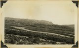
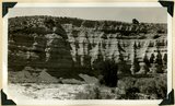
Sunset Cliffs as viewed east of Hatch. Sevier fault follows base of cliffs that include Cretaceous and Wasatch Pink Cliffs on skyline. Garfield County, UT, 1939 | P0013 Herbert E. Gregory Photograph Collection | P0013n11_098_2685 |
| 140 |
 |
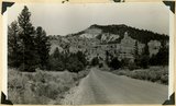
East Creek Valley, Union Pacific pump house | P0013 Herbert E. Gregory Photograph Collection | P0013n11_105_2697 |
| 141 |
 |
Erosion of Cretaceous beds in Paria Valley east of Tropic; Wasatch formation on horizon. View looking east near mouth of Henderson Valley. Garfield County, UT. 1940 | P0013 Herbert E. Gregory Photograph Collection | P0013n11_107_2698 |
| 142 |
 |
Wilson Peak, head of Hillsdale Canyon. Wasatch limestone overlying the Kaiparowits formation. Garfield County, UT, 1940 | P0013 Herbert E. Gregory Photograph Collection | P0013n11_123_2711 |
| 143 |
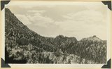 |
View in Hillsdale Gap in Sunset Cliffs looking east; along a fault masses of Wasatch (center and right) are dropped below corresponding beds (upper left). Garfield County, UT, 1940 | P0013 Herbert E. Gregory Photograph Collection | P0013n11_124_2712 |
| 144 |
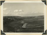 |
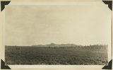
Sevier River Valley north of Hatch, UT | P0013 Herbert E. Gregory Photograph Collection | P0013n11_124_2713 |
| 145 |
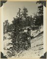 |
Foxtail pine, Bryce Canyon National Park | P0013 Herbert E. Gregory Photograph Collection | P0013n11_127_2717 |
| 146 |
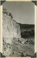 |
Walls of alluvium along Red Creek. Garfield County, UT, 1940 | P0013 Herbert E. Gregory Photograph Collection | P0013n11_127_2718 |
| 147 |
 |
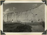
Walls of alluvium along Red Creek, with post-Wasatch underlying (right). Garfield County, UT, 1940 | P0013 Herbert E. Gregory Photograph Collection | P0013n11_128_2719 |
| 148 |
 |
Alluvial wall of trench dug since 1920(?), post Wasatch marls at base. Red Creek. Garfield County, UT, 1940 | P0013 Herbert E. Gregory Photograph Collection | P0013n11_128_2720 |
| 149 |
 |
Bedded clays and lime silts. Pleistocene(?) lacustrine deposits overlain by basalt, Castro Canyon. Garfield County, UT, 1940 | P0013 Herbert E. Gregory Photograph Collection | P0013n11_130_2721 |
| 150 |
 |
Post Wasatch Sevier(?) formation (foreground and center) capped by lavas of Sevier Plateau (horizon) at head of north fork of Linekiln Wash. Garfield County, UT, 1940 | P0013 Herbert E. Gregory Photograph Collection | P0013n11_132_2722 |