|
|
Title | Collection Number And Name | Photo Number |
| 51 |
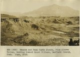 |
Mancos and Mesa Verde strata, Pine Alcove Valley, looking toward Mount Hillers, Garfield County, Utah, June, 1915. | P0013 Herbert E. Gregory Photograph Collection | P0013n08_029_1365 |
| 52 |
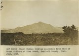 |
Mount Holmes looking southeast from base of Mount Hillers at Star Ranch, Garfield County, Utah, June, 1915. | P0013 Herbert E. Gregory Photograph Collection | P0013n08_029_1366 |
| 53 |
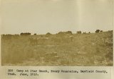 |
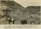
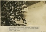
Camp at Star Ranch, Henry Mountains, Garfield County, Utah, June, 1915. | P0013 Herbert E. Gregory Photograph Collection | P0013n08_030_1367 |
| 54 |
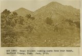 |
Mount Hillers looking north from Star Ranch, Garfield County, Utah, June, 1915. | P0013 Herbert E. Gregory Photograph Collection | P0013n08_030_1368 |
| 55 |
 |
View looking east from near divide at head of Water Pocket Canyon. Cretaceous strata, hogback. Garfield County, UT. June 1918 | P0013 Herbert E. Gregory Photograph Collection | P0013n08_067_1431 |
| 56 |
 |
Head of Water Pocket Valley. Sharp turn in axis of fold in Cretaceous sandstone. Garfield County, UT. June 1918 | P0013 Herbert E. Gregory Photograph Collection | P0013n08_067_1432 |
| 57 |
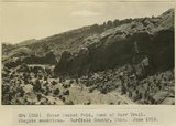 |
Water Pocket Fold, head of Burr Trail. Wingate sandstone. Garfield County, UT. June 1918 | P0013 Herbert E. Gregory Photograph Collection | P0013n08_068_1433 |
| 58 |
 |
Water Pocket Fold near foot of Burr Trail. General view Cretaceous strata. Garfield County, UT. June 1918 | P0013 Herbert E. Gregory Photograph Collection | P0013n08_068_1434 |
| 59 |
 |
East of the foot of Burr Trail, Water Pocket Fold. Cretaceous strata. Garfield County, UT. June 1918 | P0013 Herbert E. Gregory Photograph Collection | P0013n08_069_1435 |
| 60 |
 |
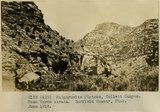
Scene in Silver Falls Canyon.Garfield County, UT. June 1918 | P0013 Herbert E. Gregory Photograph Collection | P0013n08_082_1461 |
| 61 |
 |
Upper Silver Falls Canyon. Chinle strata below Wingate. Garfield County, UT. June 1918 | P0013 Herbert E. Gregory Photograph Collection | P0013n08_082_1462 |
| 62 |
 |
Upper Silver Falls Canyon. Chinle beds below Wingate. Garfield County, UT. June 1918 | P0013 Herbert E. Gregory Photograph Collection | P0013n08_083_1463 |
| 63 |
 |
Silver Falls Canyon. Middle LaPlata and Navajo sandstone. Garfield County, UT. June 1918 | P0013 Herbert E. Gregory Photograph Collection | P0013n08_083_1464 |
| 64 |
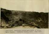 |
Escalante Canyon near mouth of Silver Falls Canyon. Garfield County, UT. June 1918 | P0013 Herbert E. Gregory Photograph Collection | P0013n08_084_1465 |
| 65 |
 |
Harris Canyon, tributary to Escalante Canyon. Navajo strata. Garfield County, UT. June 1918 | P0013 Herbert E. Gregory Photograph Collection | P0013n08_084_1466 |
| 66 |
 |
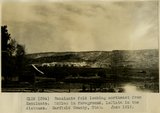
Escalante gorge, looking from Escalante across river flat. Garfield County, UT. June 1918 | P0013 Herbert E. Gregory Photograph Collection | P0013n08_085_1467 |
| 67 |
 |
Escalante fold looking northeast from Escalante. McElmo is in foreground, LaPlata in the distance. Garfield County, UT. June 1918 | P0013 Herbert E. Gregory Photograph Collection | P0013n08_085_1468 |
| 68 |
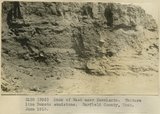 |
Bank of Wash near Escalante. Texture like Dakota sandstone. Garfield County, UT. June 1918 | P0013 Herbert E. Gregory Photograph Collection | P0013n08_086_1469 |
| 69 |
 |
Crossing Escalante River at point where sand dunes bury the canyon walls, near mouth of Silver Falls Canyon. Garfield County, UT. June 1918 | P0013 Herbert E. Gregory Photograph Collection | P0013n08_086_1470 |
| 70 |
 |
Kaiparowits Plateau, Camp Collett Canyon. Mesa Verde strata. Garfield County, UT. June 1918 | P0013 Herbert E. Gregory Photograph Collection | P0013n08_095_1490 |
| 71 |
 |
Kaiparowits Plateau, Collett Canyon. Mesa Verde strata. Garfield County, UT. June 1918 | P0013 Herbert E. Gregory Photograph Collection | P0013n08_096_1491 |
| 72 |
 |
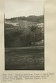
Escalante. Mormon tithing yard. Garfield County, UT. June 1918 | P0013 Herbert E. Gregory Photograph Collection | P0013n08_096_1492 |
| 73 |
 |
Escalante. Red Cross Day, procession. Garfield County, UT. June 1918 | P0013 Herbert E. Gregory Photograph Collection | P0013n08_097_1493 |
| 74 |
 |
Escalante. Red Cross Day, procession. Garfield County, UT. June 1918 | P0013 Herbert E. Gregory Photograph Collection | P0013n08_097_1494 |
| 75 |
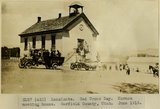 |
Escalante. Red Cross Day. Mormon meeting house. Garfield County, UT. June 1918 | P0013 Herbert E. Gregory Photograph Collection | P0013n08_098_1495 |