Home
Browse
Ask Us
Chat
Harmful Language Statement
Log in
Photo Archives
Advanced Search
About
Over 90,000 photos covering a variety of topics from Marriott Library Special Collections.
Year
1872
1873
1874
1875
1876
1877
1878
1879
1880
1881
1882
1883
1884
1885
1886
1887
1888
1889
1890
1891
1892
1893
1894
1895
1896
1897
1898
1899
1900
1901
1902
1903
1904
1905
1906
1907
1908
1909
1910
1911
1912
1913
1914
1915
1916
1917
1918
1919
1920
1921
1922
1923
1924
1925
1926
1927
1928
1929
1930
1931
1932
1933
1934
1935
1936
1937
1938
1939
1940
1941
1942
1943
1944
1945
1946
1947
1948
1949
1950
1951
1952
1953
1954
1955
1956
1957
1958
1959
1960
1961
1962
1963
1964
1965
1966
1967
1968
1969
1970
1971
1972
1973
1974
1975
1976
1977
1978
1979
1980
1981
1982
1983
1984
1985
1986
1987
1988
1989
1990
1991
1992
1993
1994
1995
1996
1997
1998
TO
1872
1873
1874
1875
1876
1877
1878
1879
1880
1881
1882
1883
1884
1885
1886
1887
1888
1889
1890
1891
1892
1893
1894
1895
1896
1897
1898
1899
1900
1901
1902
1903
1904
1905
1906
1907
1908
1909
1910
1911
1912
1913
1914
1915
1916
1917
1918
1919
1920
1921
1922
1923
1924
1925
1926
1927
1928
1929
1930
1931
1932
1933
1934
1935
1936
1937
1938
1939
1940
1941
1942
1943
1944
1945
1946
1947
1948
1949
1950
1951
1952
1953
1954
1955
1956
1957
1958
1959
1960
1961
1962
1963
1964
1965
1966
1967
1968
1969
1970
1971
1972
1973
1974
1975
1976
1977
1978
1979
1980
1981
1982
1983
1984
1985
1986
1987
1988
1989
1990
1991
1992
1993
1994
1995
1996
1997
1998
Type
Image
1,767
Image/StillImage
175
Format
image/jpeg
1,828
application/pdf
114
Collection Name
Herbert E. Gregory
1,197
Frederick Hoffman Wood
321
Olive Woolley Burt
93
S.J. Quinney
82
Frederick J. Pack
76
Grand Canyon
26
Everett Ruess Family
22
Mitchell H. Kline
17
Wasatch Mountain Club
16
Carl Weeks
14
Miles Pratt Romney
11
William Dawson
11
Elbert M. Dansie
10
Gus Scott
8
Mickey Ibarra
7
Wallace Stegner
7
Fred Harvey
5
Grace Fites
4
Sonia Johnson
3
Lyman P. Hunter
2
Marriner S. Eccles
2
Joseph E. Johnson
1
LaVar Webb
1
Marvin J. Bertoch
1
Ray Yourdon
1
Rocky Mountain Power Company
1
Salt Lake Oratorio Society
1
William C. Bradley
1
William M. Purdy
1
More
Filters:
Collection:
"uum_map"
Spatial Coverage:
"Arizona"
1201
-
1225
of
1,942
<
44
45
46
47
48
49
50
51
52
53
>
Gallery view
Number of results to display per page
10
25
50
100
200
Sort by Relevance
Sort by Title A-Z
Sort by Title Z-A
Sort by Date Ascending
Sort by Date Descending
Sort by Last Modified Ascending
Sort by Last Modified Descending
Sort by Photo Number
Title
Collection Number And Name
Photo Number
1201
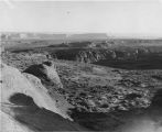
Kaibab Indian School near Moccasin looking northeast toward head of Two Mile Wash. Deep alluvial fill. Moenkopi capped by Shinarump (upper right), Chinle and Glen Canyon beds cliffs at upper left and middle distance (Lambs Point). Branch of Sevier fault crosses divide between Two Mile Wash and Sand Creek at base of Indian Point (left middle), Mohave County, AZ. 1939
P0013 Herbert E. Gregory Photograph Collection
P0013n11_089_2670
1202
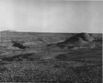
Kaibab Indian School looking north. Alluvial flats at head of Two Mile Wash. Branch of Sevier fault passes between Navajo (left distance) and Chinle-Navajo (middle distance), Mohave County, AZ. 1939
P0013 Herbert E. Gregory Photograph Collection
P0013n11_089_2671
1203
'Winsor Castle,' old stone fort at Pipe Springs, Mohave County, AZ. Sevier fault passes between Navajo sandstone." (upper right) and lower Moenkopi (foreground). 1939
P0013 Herbert E. Gregory Photograph Collection
P0013n11_090_2672
1204
Bridge built by C.C.C. across recently eroded wash, near Pipe Springs. Mohave County, AZ. 1939
P0013 Herbert E. Gregory Photograph Collection
P0013n11_098_2686
1205
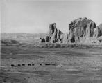
Cedar Ridge. Cap of Shinarump conglomerate and upper Moenkopi extending south from Vermillion Cliffs onto Uinkaret Plateau west of Pipe Wash, Mohave County, AZ. 1939
P0013 Herbert E. Gregory Photograph Collection
P0013n11_099_2687
1206
Settlement of Moccasin Springs looking eastward toward Kaibab Indian School. Kaibab Plateau on skyline. Mohave County, AZ. 1939
P0013 Herbert E. Gregory Photograph Collection
P0013n11_099_2688
1207
View northward over Moccasin Springs along Sevier fault. Navajo (left) and Chinle (right), on skyline. 1939. Deep alluvium trenched by stream from springs (foreground)
P0013 Herbert E. Gregory Photograph Collection
P0013n11_100_2689
1208
'Winsor Castle', old fort at Pipe Springs, looking south over Unikaret Plateau, Kanab Canyon upper right
P0013 Herbert E. Gregory Photograph Collection
P0013n11_101_2690
1209
Door of "Winsor Castle," Pipe Springs, Mohave County, Ariz. 1939
P0013 Herbert E. Gregory Photograph Collection
P0013n11_101_2691
1210
Walls of "Winsor Castle," headquarters for Pipe Springs National Monument. Modern doors and windows replace "rifle grooves," Mohave Co., Ariz. 1939
P0013 Herbert E. Gregory Photograph Collection
P0013n11_102_2692
1211
Erosion surface at edge of Vermillion Cliffs west of Pipe Springs, Mohave County, AZ. Streams cross Sevier fault from downthrow to upthrow side. 1939
P0013 Herbert E. Gregory Photograph Collection
P0013n11_102_2693
1212
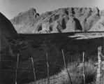
Cowboy Butte 2 miles north of Fredonia. Moenkopi (Shnabkaib member at base) and Shinarump, Coconino County, AZ. 1939
P0013 Herbert E. Gregory Photograph Collection
P0013n11_103_2694
1213
Timpoweap member of the Moenkopi formation. Kaibab at base, upstream. East rim of the Kaibab Plateau near the UT-AZ line. Coconino County, AZ, 1944
P0013 Herbert E. Gregory Photograph Collection
P0013n12_049_2901
1214
Glen Canyon
P0031 William Dawson Photograph Collection
P0031n1_09_50
1215
Glen Canyon
P0031 William Dawson Photograph Collection
P0031n1_09_51
1216
Glen Canyon
P0031 William Dawson Photograph Collection
P0031n1_09_52
1217
Glen Canyon
P0031 William Dawson Photograph Collection
P0031n1_09_53
1218
Glen Canyon
P0031 William Dawson Photograph Collection
P0031n1_09_54
1219
Glen Canyon
P0031 William Dawson Photograph Collection
P0031n1_09_55
1220
Glen Canyon
P0031 William Dawson Photograph Collection
P0031n1_09_56
1221
Glen Canyon
P0031 William Dawson Photograph Collection
P0031n1_09_57
1222
Glen Canyon
P0031 William Dawson Photograph Collection
P0031n1_09_58
1223
Glen Canyon
P0031 William Dawson Photograph Collection
P0031n1_09_60
1224
Glen Canyon
P0031 William Dawson Photograph Collection
P0031n1_09_61
1225
Squire Coop [5]
P0097 Salt Lake Oratorio Society photograph collection
P0097n02_02_181
1201
-
1225
of
1,942
<
44
45
46
47
48
49
50
51
52
53
>