| | Title | Collection Number And Name | Photo Number |
|---|
| 1176 | 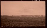 | Block mesas from south, panorama. | P0013 Herbert E. Gregory Photograph Collection | P0013n10_174_2391A |
| 1177 |  | Plateau south of Block Mesas | P0013 Herbert E. Gregory Photograph Collection | P0013n10_176_2395 |
| 1178 | 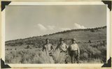 | Plateau south of Block mesas. Grantham, Stringham, and guide (right), 1937. | P0013 Herbert E. Gregory Photograph Collection | P0013n10_176_2395 |
| 1179 | 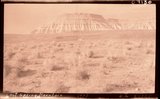 | Lost Spring Mountain, 1937. | P0013 Herbert E. Gregory Photograph Collection | P0013n10_177_2398 |
| 1180 | 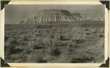 | Moenkopi capped by Shinarump, Lost Spring Mountain, 1937. | P0013 Herbert E. Gregory Photograph Collection | P0013n10_177_2398 |
| 1181 | 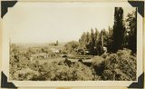 | Moccasin Springs, 1936. | P0013 Herbert E. Gregory Photograph Collection | P0013n10_186_2414 |
| 1182 | 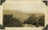 | Kaibab Indian School, 1936. | P0013 Herbert E. Gregory Photograph Collection | P0013n10_186_2416 |
| 1183 | 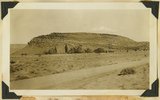 | Navajo, Pipe Springs, 1936. | P0013 Herbert E. Gregory Photograph Collection | P0013n10_187_2417 |
| 1184 | 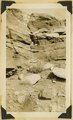 | Navajo contact, Pipe Springs, 1936. | P0013 Herbert E. Gregory Photograph Collection | P0013n10_187_2418 |
| 1185 | 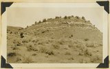 | Slice of Chinle on Sevier fault, Pipe Springs-Moccasin road, 1936. | P0013 Herbert E. Gregory Photograph Collection | P0013n10_187_2419 |
| 1186 | 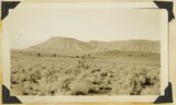 | Moenkopi and lava, Little Creek, 1936. | P0013 Herbert E. Gregory Photograph Collection | P0013n10_189_2424 |
| 1187 |  | A. M. Thompson, Kanab Creek, 1872. | P0013 Herbert E. Gregory Photograph Collection | P0013n10_220_2485 |
| 1188 |  | Herbert E. Gregory Book 11: Colorado Plateau, 1938-1942 | P0013 Herbert E. Gregory Photograph Collection | P0013n11 |
| 1189 |  | The Steamboat. Shnabkaib (bottom) and upper red level of Moenkopi capped in part by Shinarump 2 miles west of Fredonia, Coconino County, AZ. 1939 | P0013 Herbert E. Gregory Photograph Collection | P0013n11_061_2628 |
| 1190 |  | The Steamboat. Shnabkaib (bottom) and upper red level of Moenkopi capped in part by Shinarump 2 miles west of Fredonia, Coconino County, AZ. 1939 | P0013 Herbert E. Gregory Photograph Collection | P0013n11_062_2629 |
| 1191 |  | Northern edge Kanab Plateau. Village of Fredonia on surface eroded from lower Moenkopi beds and crossed by Kanab Creek. Buttes of Moenkopi capped by Shinarump (right), Coconino County, August, 1939 | P0013 Herbert E. Gregory Photograph Collection | P0013n11_067_2637 |
| 1192 | 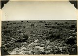 | Surface of Uinkaret Plateau southwest of Cane Beds, Mohave County, AZ, Aug. 2, 1939 | P0013 Herbert E. Gregory Photograph Collection | P0013n11_067_2638 |
| 1193 |  | Shinarump and Moenkopi beds disturbed by a local fault 3 miles north of Fredonia, Coconino County, AZ. 1939 | P0013 Herbert E. Gregory Photograph Collection | P0013n11_069_2641 |
| 1194 | 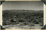 | Erosion surface produced by bevelling Chinle strata at the base of Vermillion Cliffs south of Cane Beds, Mohave County, AZ, 1939 | P0013 Herbert E. Gregory Photograph Collection | P0013n11_073_2648 |
| 1195 | 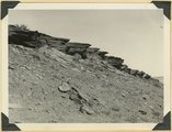 | Moenkopi showing typical erosion of its shaly sandstones on Hurricane-Antelope Springs Road, Mohave County, AZ. 1939 | P0013 Herbert E. Gregory Photograph Collection | P0013n11_074_2649 |
| 1196 | 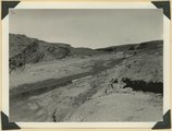 | Fault in lower Moenkopi shaly sandstone head of Rock Canyon (of Short Creek), Mohave County, AZ, 1939 | P0013 Herbert E. Gregory Photograph Collection | P0013n11_075_2651 |
| 1197 |  | Folds in Moenkopi strata, Short Creek east of Rock Canyon, Mohave County, AZ, 1939 | P0013 Herbert E. Gregory Photograph Collection | P0013n11_075_2652 |
| 1198 |  | South wall of Rock Canyon. Kaibab (on valley floor and up to first ledge), conglomerate, Moenkopi (upper part of slope and the cliffs), Mohave County, AZ, 1939 | P0013 Herbert E. Gregory Photograph Collection | P0013n11_076_2653 |
| 1199 |  | Short Creek near the exit from its canyon, in Vermillion Cliffs. Alluvial terraces and broad channel made during past 50 years, Mohave County, AZ, 1939 | P0013 Herbert E. Gregory Photograph Collection | P0013n11_076_2654 |
| 1200 | 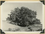 | Cottonwood trees buried by sand dunes; trunks reexposed by recent excavations of alluvial valley fill, Short Creek, Mohave County, AZ, 1939 | P0013 Herbert E. Gregory Photograph Collection | P0013n11_077_2655 |