| | Title | Collection Number And Name | Photo Number |
|---|
| 1151 |  | Panoramic with view attached | P0013 Herbert E. Gregory Photograph Collection | P0013n08_170_1666 |
| 1152 | 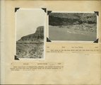 | Herbert E. Gregory Book 10: San Juan, Zion, Capitol Reef, 1915-1938 | P0013 Herbert E. Gregory Photograph Collection | P0013n10 |
| 1153 | 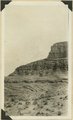 | Rocks equivalent to Summerville, Entrada, and Carmel formations as exposed one-half mile east of Laguna Creek and 10 miles southeast of Garnet Ridge: Arizona, Apache County, 1928. | P0013 Herbert E. Gregory Photograph Collection | P0013n10_001_2091 |
| 1154 |  | Same as 377 (no further identification) | P0013 Herbert E. Gregory Photograph Collection | P0013n10_002_2094 |
| 1155 | 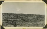 | Banded Navajo sandstone near place where Wingate and Kayenta first lose their identity. Chinle immediately below. Two miles northwest of Pipe Springs, Mohave County, Arizona, 1936. | P0013 Herbert E. Gregory Photograph Collection | P0013n10_151_2348 |
| 1156 | 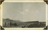 | Kaibab Indian School looking north. Cliffs at left, Chinle capped by Wingate-Navajo. Cuesta at left, Moenkop capped by Shinarump. Mohave County, Arizona, 1936. | P0013 Herbert E. Gregory Photograph Collection | P0013n10_152_2349 |
| 1157 | 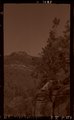 | N.E. Pipe Springs | P0013 Herbert E. Gregory Photograph Collection | P0013n10_154_2353 |
| 1158 | 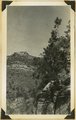 | Navajo-Wingate on Chinle, 2 miles northeast Pipe Springs, 1936. | P0013 Herbert E. Gregory Photograph Collection | P0013n10_154_2353 |
| 1159 |  | Pipe Springs | P0013 Herbert E. Gregory Photograph Collection | P0013n10_155_2354 |
| 1160 |  | "Windsor Castle," Pipe Springs, 1936. | P0013 Herbert E. Gregory Photograph Collection | P0013n10_155_2354 |
| 1161 |  | Sand dunes, head of Sand Canyon, 1936. | P0013 Herbert E. Gregory Photograph Collection | P0013n10_155_2355 |
| 1162 | 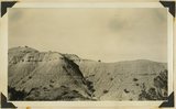 | Chinle "marls," Sand Wash, Mohave County, Arizona, 1936. | P0013 Herbert E. Gregory Photograph Collection | P0013n10_157_2358 |
| 1163 | 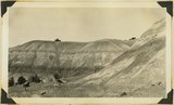 | Chinle "marls," Sand Wash, Mohave County, Arizona, 1936. | P0013 Herbert E. Gregory Photograph Collection | P0013n10_157_2359 |
| 1164 | 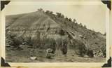 | Chinle "marls," Sand Wash, Mohave County, Arizona, 1936. | P0013 Herbert E. Gregory Photograph Collection | P0013n10_158_2360 |
| 1165 | 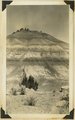 | Chinle "marls," Sand Wash, Mohave County, Arizona, 1936. | P0013 Herbert E. Gregory Photograph Collection | P0013n10_158_2361 |
| 1166 | 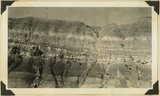 | Chinle "marls," Sand Wash, Mohave County, Arizona, 1936. | P0013 Herbert E. Gregory Photograph Collection | P0013n10_159_2362 |
| 1167 | 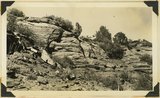 | Navajo sandstone 200 feet above Chinle Rosencrans Wash. No Kayenta at Wingate in the section. Mohave County, Arizona, 1936. | P0013 Herbert E. Gregory Photograph Collection | P0013n10_160_2365 |
| 1168 | 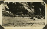 | Bottom of Glen Canyon group. Color banded cross-bed sandstone in positions of Wingate, Rosencrans Wash, Mohave County, Arizona, 1936. | P0013 Herbert E. Gregory Photograph Collection | P0013n10_161_2366 |
| 1169 |  | Steamboat Rock. Moenkopi capped by Shinarump white Shanakaib member at base. On Fredonia-Pipe Springs road, Mohave County, Arizona, 1936. | P0013 Herbert E. Gregory Photograph Collection | P0013n10_161_2367 |
| 1170 |  | Color banded Navajo-Wingate, Sand Wash, 1936. | P0013 Herbert E. Gregory Photograph Collection | P0013n10_164_2372 |
| 1171 | 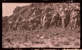 | Sand Wash, 1936 | P0013 Herbert E. Gregory Photograph Collection | P0013n10_164_2372 |
| 1172 | 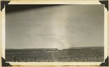 | View looking west toward Canaan Gap of Short Creek. Road on Arizona-Utah line; foreground, flat cut in lowest Chinle beds; background, cliffs and ridges of eastward dipping Shinarump overlying Moenkopi. Washington County, Utah, 1937. | P0013 Herbert E. Gregory Photograph Collection | P0013n10_171_2386 |
| 1173 | 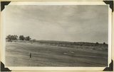 | Short Creek near village of Short Creek. Cutting of its channel 20-30 feet done since about 1885. Mohave County, Arizona, 1937. | P0013 Herbert E. Gregory Photograph Collection | P0013n10_172_2387 |
| 1174 |  | Same as 799 (Short Creek near village of Short Creek. Cutting of its channel 20-30 feet done since about 1885. Mohave County, Arizona, 1937). Point of Vermillion Cliff in upper left. | P0013 Herbert E. Gregory Photograph Collection | P0013n10_172_2388 |
| 1175 | 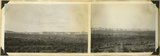 | Block mesas from the south, panorama. | P0013 Herbert E. Gregory Photograph Collection | P0013n10_174_2391 |