Over 90,000 photos covering a variety of topics from Marriott Library Special Collections.
| Title | Collection Number And Name | Photo Number | ||
|---|---|---|---|---|
| 976 |  | Wind work in LaPlata, north of Tuba | P0013 Herbert E. Gregory Photograph Collection | P0013n07_025_1070 |
| 977 | 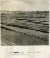 | Rock floor, La Plata, north of Tuba | P0013 Herbert E. Gregory Photograph Collection | P0013n07_026_1071 |
| 978 | 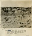 | Beveling of McElmo and conglomerate cap. Edge of Blue Canon, 1 1/2 mile north of old Blue Canon store. | P0013 Herbert E. Gregory Photograph Collection | P0013n07_026_1072 |
| 979 | 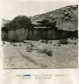 | Unconformity. McElmo-Dakota. Blue Canon. | P0013 Herbert E. Gregory Photograph Collection | P0013n07_027_1073 |
| 980 | 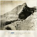 | "Painted Desert", four miles west of Tuba | P0013 Herbert E. Gregory Photograph Collection | P0013n07_028_1074 |
| 981 | 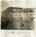 | "Painted Desert", 2 mi. west of Tuba | P0013 Herbert E. Gregory Photograph Collection | P0013n07_029_1075 |
| 982 |  | Same as 827 ["Painted Desert", 2 mi. west of Tuba] | P0013 Herbert E. Gregory Photograph Collection | P0013n07_030_1076 |
| 983 | 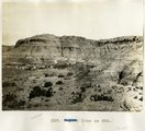 | Same as 826 ["Painted Desert", four miles west of Tuba] | P0013 Herbert E. Gregory Photograph Collection | P0013n07_031_1077 |
| 984 |  | Showing the peneplain levels north of old store, Blue Canon | P0013 Herbert E. Gregory Photograph Collection | P0013n07_033_1079 |
| 985 |  | Beveling below Black Falls, looking north. | P0013 Herbert E. Gregory Photograph Collection | P0013n07_035_1081 |
| 986 | 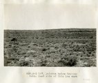 | Dolores below Tse-na-kahn. East side of Chin lee wash | P0013 Herbert E. Gregory Photograph Collection | P0013n07_036_1082 |
| 987 |  | La Plata, Marsh Pass. looking northwest toward mouth of Sagy. | P0013 Herbert E. Gregory Photograph Collection | P0013n07_037_1083 |
| 988 |  | La Plata in Marsh Pass | P0013 Herbert E. Gregory Photograph Collection | P0013n07_038_1084 |
| 989 | 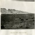 | Same as 835 [La Plata in Marsh Pass] | P0013 Herbert E. Gregory Photograph Collection | P0013n07_039_1085 |
| 990 |  | Same as 835 [La Plata in Marsh Pass] | P0013 Herbert E. Gregory Photograph Collection | P0013n07_040_1086 |
| 991 |  | Bridge, Little Colorado | P0013 Herbert E. Gregory Photograph Collection | P0013n07_041_1087 |
| 992 | 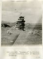 | "Monument" in Painted Desert formation east of Tanners Crossing. | P0013 Herbert E. Gregory Photograph Collection | P0013n07_042_1088 |
| 993 |  | Rock floor, La Plata, north of Tuba | P0013 Herbert E. Gregory Photograph Collection | P0013n07_043_1089 |
| 994 | 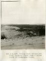 | Valley that drains Red Lake. Looking north from 2 miles north of Moencopie Canon. | P0013 Herbert E. Gregory Photograph Collection | P0013n07_044_1090 |
| 995 | 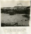 | Beveling and conglomerate cap of lower peneplain, north side Blue Canon, opposite old store. | P0013 Herbert E. Gregory Photograph Collection | P0013n07_045_1091 |
| 996 | 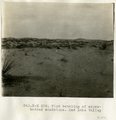 | Wind beveling of cross-bedded sandstone, Red Lake Valley | P0013 Herbert E. Gregory Photograph Collection | P0013n07_046_1092 |
| 997 |  | Sand dune and rock floor north of Tuba | P0013 Herbert E. Gregory Photograph Collection | P0013n07_050_1096 |
| 998 |  | Dolores east of Black Falls | P0013 Herbert E. Gregory Photograph Collection | P0013n07_051a_1098 |
| 999 | 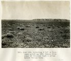 | Pointing N 14° E from same point as 199. Taken from edge of Chinlee Wash 2 miles below Tse-na-kahn | P0013 Herbert E. Gregory Photograph Collection | P0013n07_052_1099 |
| 1000 |  | Pointing N 76° E from same point as 198. Taken from edge of Chinlee Wash 2 miles below Tse-na-kahn | P0013 Herbert E. Gregory Photograph Collection | P0013n07_053_1100 |