Over 90,000 photos covering a variety of topics from Marriott Library Special Collections.
TO
| Title | Collection Number And Name | Photo Number | ||
|---|---|---|---|---|
| 926 |
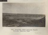 | View Dolores Fossil Forest, Carrizo Wash (Photo N-M185) | P0013 Herbert E. Gregory Photograph Collection | P0013n06_096_1019 |
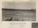
| 927 |
 | Same as 770 (Dolores Fossil Forest, Photo G444) | P0013 Herbert E. Gregory Photograph Collection | P0013n06_097_1020 |
| 928 |
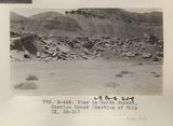 | View in North Forest, Carrizo Creek (Section of this IX, 32-33) (Photo G445) | P0013 Herbert E. Gregory Photograph Collection | P0013n06_097_1021 |
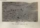
| 929 |
 | Same as 772 (North Forest, Carrizo Creek, Photo G446) | P0013 Herbert E. Gregory Photograph Collection | P0013n06_098_1022 |
| 930 |
 | "North Forest", Carrizo Creek Wash (Photo G447) | P0013 Herbert E. Gregory Photograph Collection | P0013n06_098_1023 |
| 931 |
 | Same as 774 (North Forest, Carrizo Creek, Photo N-M186) | P0013 Herbert E. Gregory Photograph Collection | P0013n06_099_1024 |
| 932 |
 | Same as 775 (North Forest, Carrizo Creek, Photo G448) | P0013 Herbert E. Gregory Photograph Collection | P0013n06_099_1025 |
| 933 |
 | Same as 774 (North Forest, Carrizo Creek, Photo G449) | P0013 Herbert E. Gregory Photograph Collection | P0013n06_100_1026 |
| 934 |
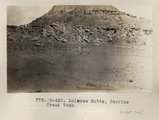 | Dolores Butte, Carrizo Creek Wash (Photo G450) | P0013 Herbert E. Gregory Photograph Collection | P0013n06_100_1027 |
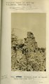
| 935 |
 | Petrified Tree butt, Carrizo Creek Wash (Photo G451) | P0013 Herbert E. Gregory Photograph Collection | P0013n06_101_1028 |
| 936 |
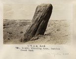 | Standing tree, Carrizo Creek Wash (Photo G452) | P0013 Herbert E. Gregory Photograph Collection | P0013n06_101_1029 |
| 937 |
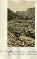
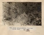 | Rock talus stream, Carrizo Creek Wash (Photo G452a) | P0013 Herbert E. Gregory Photograph Collection | P0013n06_102_1030 |
| 938 |
 | Herbert E. Gregory Book 7: Navajo, 1913, 1914 | P0013 Herbert E. Gregory Photograph Collection | P0013n07 |
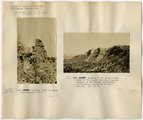
| 939 |
 | Chimney Rock on Tees-Nos-Pos trail | P0013 Herbert E. Gregory Photograph Collection | P0013n07_001_1031 |
| 940 |
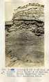
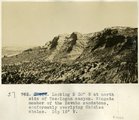 | Looking S 30° W at north side of Tse-logan Canyon. Wingate member of the Navajo sandstone, conformably overlying Chinlee shales. Dip 15 degrees W | P0013 Herbert E. Gregory Photograph Collection | P0013n07_001_1032 |
| 941 |
 | Carrizo Mt. looking 50° W at south side of Tse-lagai canyon. Wingate member of Navaho sandstone, conformably overlying Chinlee shale. Dip 15 degrees W | P0013 Herbert E. Gregory Photograph Collection | P0013n07_002_1033 |
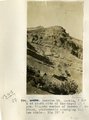
| 942 |
 | Carrizo Mt. looking S 30° E at west end of Chejin-Dezah Mesa. Shows cirque-like basins in monsonite cliff | P0013 Herbert E. Gregory Photograph Collection | P0013n07_002_1034 |
| 943 |
 | Looking S 60° W up canyon at point where lower trail enters it. Shows terraces in stream bottom. | P0013 Herbert E. Gregory Photograph Collection | P0013n07_003_1035 |
| 944 |
 | Looking N 15° W at base of highest point 6+ mi. east of Mexican Water. Navaho sandstone below, folded; Zuni sandstone above | P0013 Herbert E. Gregory Photograph Collection | P0013n07_004_1038 |
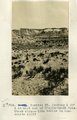
| 945 |
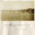 | Desert pavement between Red Lake and Tuba | P0013 Herbert E. Gregory Photograph Collection | P0013n07_005_1039 |
| 946 |
 | Desert pavement between Red Lake and Tuba | P0013 Herbert E. Gregory Photograph Collection | P0013n07_005_1040 |
| 947 |
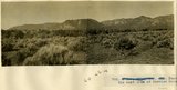
 | Panorama of the east side of Carrizo Mountain | P0013 Herbert E. Gregory Photograph Collection | P0013n07_006_1041 |
| 948 |
 | Panorama of the east side of Carrizo Mountain [left portion] | P0013 Herbert E. Gregory Photograph Collection | P0013n07_006_1041left |
| 949 |
 | Panorama of the east side of Carrizo Mountain [right portion] | P0013 Herbert E. Gregory Photograph Collection | P0013n07_006_1041right |
| 950 |
 | Same as 790 & 791 [Desert pavement between Red Lake and Tuba] | P0013 Herbert E. Gregory Photograph Collection | P0013n07_007_1042 |