Over 90,000 photos covering a variety of topics from Marriott Library Special Collections.
| Title | Collection Number And Name | Photo Number | ||
|---|---|---|---|---|
| 751 | 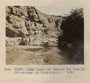 | Near head of Canyon de Chelly. Shinarump on Moencopie. 1911 (Photo G297) | P0013 Herbert E. Gregory Photograph Collection | P0013n05_84_0810 |
| 752 | 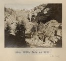 | Same as Photo G297 (Near head of Canyon de Chelly, Photo G298) | P0013 Herbert E. Gregory Photograph Collection | P0013n05_84_0811 |
| 753 | 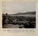 | Black Creek valley, east toward Baigaiche Mt. VI, 45, 55 (Photo G299) | P0013 Herbert E. Gregory Photograph Collection | P0013n05_85_0812 |
| 754 | 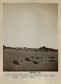 | Erosion in Dolores near Tuba. Heald, photo. 1911 (Photo G305) | P0013 Herbert E. Gregory Photograph Collection | P0013n05_90_0821 |
| 755 |  | Erosion in Dolroes near Tuba. Heald, photo. 1911 (Photo G306) | P0013 Herbert E. Gregory Photograph Collection | P0013n05_91_0822 |
| 756 | 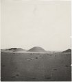 | Erosion in Dolroes near Tuba. Heald, photo. 1911 (Photo G306) | P0013 Herbert E. Gregory Photograph Collection | P0013n05_91_0822 |
| 757 |  | Herbert E. Gregory Book 6: Navajo, 1913 | P0013 Herbert E. Gregory Photograph Collection | P0013n06 |
| 758 |  | View, Todilto Park. K.C.H. photo (Photo N-M134) | P0013 Herbert E. Gregory Photograph Collection | P0013n06_001_0824 |
| 759 |  | Shinarump Conglomerate. Fort Defiance. Heald & Gregory, photo (Photo G307) | P0013 Herbert E. Gregory Photograph Collection | P0013n06_002_0825 |
| 760 | 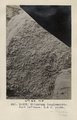 | Shinarump Conglomerate. Fort Defiance. H. & G. photo (Photo G308) | P0013 Herbert E. Gregory Photograph Collection | P0013n06_002_0826 |
| 761 | 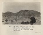 | Dolores Badlands 1 1/2 mile west of Nashlini. (I-5 & I-7 in film book just like this) (Photo N-M135) | P0013 Herbert E. Gregory Photograph Collection | P0013n06_003_0827 |
| 762 | 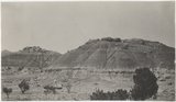 | Dolores Badlands 1 1/2 mile west of Nashlini. (I-5 & I-7 in film book just like this) (Photo N-M135) | P0013 Herbert E. Gregory Photograph Collection | P0013n06_003_0827 |
| 763 | 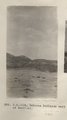 | Dolores Badlands west of Nashlini (Photo N-M136) | P0013 Herbert E. Gregory Photograph Collection | P0013n06_004_0828 |
| 764 | 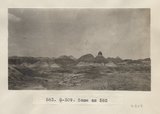 | Same as 582 (Dolores Badlands west of Nashlini, Photo G309) | P0013 Herbert E. Gregory Photograph Collection | P0013n06_004_0829 |
| 765 | 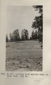 | Looking west across wash at Bear Tank. May 26 (Photo G310) | P0013 Herbert E. Gregory Photograph Collection | P0013n06_005_0830 |
| 766 | 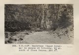 | Sandstone (Upper Permian) in canyon at Totocong, 6+ mi. south of Cross Canyon. May 27 (Photo N-M137) | P0013 Herbert E. Gregory Photograph Collection | P0013n06_005_0831 |
| 767 | 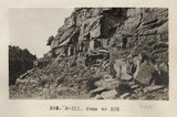 | Same as 585 (Sandstone in canyon at Totocong, Photo G311) | P0013 Herbert E. Gregory Photograph Collection | P0013n06_005_0832 |
| 768 | 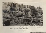 | Same as 585 (Sandstone in canyon at Totocong, Photo G312) | P0013 Herbert E. Gregory Photograph Collection | P0013n06_006_0833 |
| 769 | 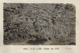 | Same as 585 (Sandstone in canyon at Totocong, Photo N-M138) | P0013 Herbert E. Gregory Photograph Collection | P0013n06_006_0834 |
| 770 | 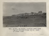 | La Plata, looking east from top of Dolores Ridge 2± mi. east of Black Rock (Photo G313) | P0013 Herbert E. Gregory Photograph Collection | P0013n06_007_0835 |
| 771 |  | La Plata sandstone 2± mi. east of Black Rock (Photo N-M139) | P0013 Herbert E. Gregory Photograph Collection | P0013n06_007_0836 |
| 772 |  | Same as 590 (La Plata east of Black Rock, Photo G314) | P0013 Herbert E. Gregory Photograph Collection | P0013n06_008_0837 |
| 773 |  | Same as 590 (La Plata east of Black Rock, Photo N-M140) | P0013 Herbert E. Gregory Photograph Collection | P0013n06_008_0838 |
| 774 | 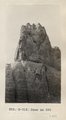 | Same as 590 (La Plata east of Black Rock, Photo G315) | P0013 Herbert E. Gregory Photograph Collection | P0013n06_008_0839 |
| 775 | 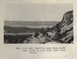 | Buell's Park from south rim. (I-20 in film book just like this) (Photo N-M141) | P0013 Herbert E. Gregory Photograph Collection | P0013n06_009_0840 |