Over 90,000 photos covering a variety of topics from Marriott Library Special Collections.
| Title | Collection Number And Name | Photo Number | ||
|---|---|---|---|---|
| 726 | 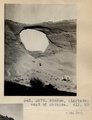 | Window, (LaPlata) west of Chinlee. VII, 29 (Photo G279) | P0013 Herbert E. Gregory Photograph Collection | P0013n05_69_0786 |
| 727 |  | Bed (4), section of Dolores and LaPlata, west of Chinlee. VII, 28 (Photo G278) | P0013 Herbert E. Gregory Photograph Collection | P0013n05_69_0787 |
| 728 |  | Window in LaPlata, west of Chinlee. Bed (1), Dolores-LaPlata section, VII, 29 (Photo G280) | P0013 Herbert E. Gregory Photograph Collection | P0013n05_70_0788 |
| 729 | 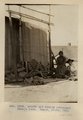 | Arnold and family (Chinlee) Navajo loom. Heald, photo, 1911 (Photo G282) | P0013 Herbert E. Gregory Photograph Collection | P0013n05_71_0789 |
| 730 |  | Petrified wood in forest south of Tsen-a-kahn. VII, 36 (Photo G283) | P0013 Herbert E. Gregory Photograph Collection | P0013n05_72_0790 |
| 731 | 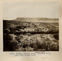 | Fossil tree, between Chinlett and Round Rock (Photo G283A) | P0013 Herbert E. Gregory Photograph Collection | P0013n05_72_0791 |
| 732 | 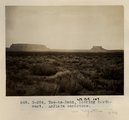 | Tse-na-kahn, looking northwest. LaPlata sandstone (Photo G-284) | P0013 Herbert E. Gregory Photograph Collection | P0013n05_73_0792 |
| 733 |  | Tse-na-kahn (Round Rock), from southeast. New Mexico. Heald, photo. 1911 (Photo N-M128) | P0013 Herbert E. Gregory Photograph Collection | P0013n05_74_0793 |
| 734 | 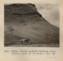 | Cross-bedded LaPlata sandstone, west of Chinlee. VII, 33 (Photo G285) | P0013 Herbert E. Gregory Photograph Collection | P0013n05_74_0794 |
| 735 | 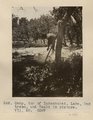 | Camp, top of Kukachukai. Lake, Oak trees, and Heald in picture. VII, 50 (Photo G287) | P0013 Herbert E. Gregory Photograph Collection | P0013n05_75_0795 |
| 736 | 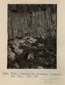 | Quartzite columns, Lukachukai Mts. VII, 50 (Photo G288) | P0013 Herbert E. Gregory Photograph Collection | P0013n05_76_0796 |
| 737 | 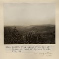 | View south from top of Butte at head of Spruce Brook. VII, 52 (Photo G-289) | P0013 Herbert E. Gregory Photograph Collection | P0013n05_76_0797 |
| 738 | 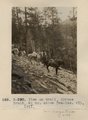 | View on trail, Spruce Brook, 5+ mi. above Tsa-lee. VII, 1911 (Photo G-290) | P0013 Herbert E. Gregory Photograph Collection | P0013n05_77_0798 |
| 739 |  | Dike, Whiskey Creek. 1911 (Photo G291) | P0013 Herbert E. Gregory Photograph Collection | P0013n05_77_0799 |
| 740 | 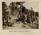 | Same as Photo G291 (Photo G291A) | P0013 Herbert E. Gregory Photograph Collection | P0013n05_78_0800 |
| 741 | 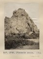 | Pinnacle Butte. 1911 (Photo G292) | P0013 Herbert E. Gregory Photograph Collection | P0013n05_78_0801 |
| 742 | 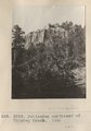 | Palisades northeast of Whiskey Creek. 1911 (Photo G293) | P0013 Herbert E. Gregory Photograph Collection | P0013n05_79_0803 |
| 743 |  | Lava flow near Sonsala. Looking northeast. Whiskey Creek in foreground (Photo G294) | P0013 Herbert E. Gregory Photograph Collection | P0013n05_79_0804 |
| 744 |  | Camp by Sonsala Buttes near Whiskey Creek. Heald, photo. 1911 (Photo N-M129) | P0013 Herbert E. Gregory Photograph Collection | P0013n05_80_0805 |
| 745 | 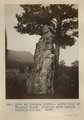 | Dike at Sonsala Buttes. South bank of Whiskey Creek, looking west toward Sonsala Buttes (Photo G295) | P0013 Herbert E. Gregory Photograph Collection | P0013n05_81_0806 |
| 746 | 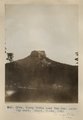 | Tubby Butte near Tsa-lee. Looking east. Heald, photo, 1911 (Photo G296) | P0013 Herbert E. Gregory Photograph Collection | P0013n05_82_0807 |
| 747 | 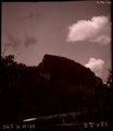 | [Whiskey Creek palisades] (Photo N-M130) | P0013 Herbert E. Gregory Photograph Collection | P0013n05_82_808_neg |
| 748 | 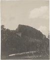 | Lava cliffs near Whiskey Creek (Palisades). Heald, photo. 1911 (Photo N-M130) | P0013 Herbert E. Gregory Photograph Collection | P0013n05_83_0808 |
| 749 | 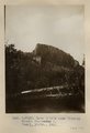 | Lava cliffs near Whiskey Creek (Palisades). Heald, photo. 1911 (Photo N-M130) | P0013 Herbert E. Gregory Photograph Collection | P0013n05_83_0808 |
| 750 |  | Canyon de Chelly. VII, 26 (Photo N-M131) | P0013 Herbert E. Gregory Photograph Collection | P0013n05_84_0809 |