| | Title | Collection Number And Name | Photo Number |
|---|
| 701 | 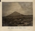 | White Cone. 1911 (Photo G258) | P0013 Herbert E. Gregory Photograph Collection | P0013n05_57_0761 |
| 702 | 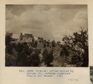 | Erosion: McElmo capped by Dakota (?), between Steamboat Canyon and Ganado. 1911 (Photo G259) | P0013 Herbert E. Gregory Photograph Collection | P0013n05_58_0762 |
| 703 | 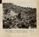 | Steamboat Canyon, unconformity, McElmo-Dakota. VII, 6 (Photo G260) | P0013 Herbert E. Gregory Photograph Collection | P0013n05_58_0763 |
| 704 | 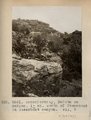 | Unconformity, Dakota on McElmo, 1± mi. south of Steamboat in Steamboat canyon. VII, 7 (Photo G261) | P0013 Herbert E. Gregory Photograph Collection | P0013n05_59_0764 |
| 705 | 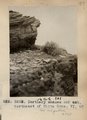 | Tertiary shales and ash, northeast of White Cone. VI, 63 (Photo G263) | P0013 Herbert E. Gregory Photograph Collection | P0013n05_59_0765 |
| 706 | 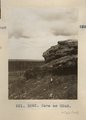 | Same as Photo G263 (White Cone, Photo G262) | P0013 Herbert E. Gregory Photograph Collection | P0013n05_59_0766 |
| 707 | 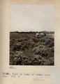 | Flat at head of Keams Canyon. VII, 3 (Photo G263A) | P0013 Herbert E. Gregory Photograph Collection | P0013n05_60_0767 |
| 708 | 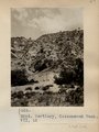 | Tertiary, Cottonwood Wash. VII, 12 (Photo G264) | P0013 Herbert E. Gregory Photograph Collection | P0013n05_60_0768 |
| 709 | 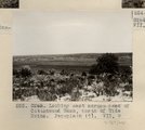 | Looking east across head of Cottonwood Wash, north of Wide Ruins. Peneplain (?). VII, 9 (Photo G265) | P0013 Herbert E. Gregory Photograph Collection | P0013n05_60_0769 |
| 710 | 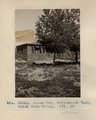 | Stone Hut, Cottonwood Wash, below Wide Ruins. VII, 10 (Photo G265A) | P0013 Herbert E. Gregory Photograph Collection | P0013n05_61_0770 |
| 711 | 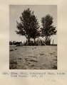 | Well, Cottonwood Wash, below Wide Ruins. VII, 10 (Photo G266) | P0013 Herbert E. Gregory Photograph Collection | P0013n05_61_0771 |
| 712 | 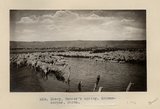 | Sheep, Tanner's spring. Schwemberger, photo | P0013 Herbert E. Gregory Photograph Collection | P0013n05_62_0772 |
| 713 |  | Erosion in Dolores, Beautiful Valley, north of Ganado. 1911 (Photo G267) | P0013 Herbert E. Gregory Photograph Collection | P0013n05_63_0773 |
| 714 |  | Erosion column and window, Nazlini canyon, above store. 1911 (Photo G268) | P0013 Herbert E. Gregory Photograph Collection | P0013n05_64_0774 |
| 715 |  | Cross bedding, Nazlini canyon, 2± mi. above store. Moencopie. 1911 (Photo G269) | P0013 Herbert E. Gregory Photograph Collection | P0013n05_65_0775 |
| 716 |  | Unconformity, Shinarump on Moencopie, Nazlini canyon, 3± mi. below store. VII, 23 (Photo G270) | P0013 Herbert E. Gregory Photograph Collection | P0013n05_65_0776 |
| 717 |  | Old store, Nazlini canyon, VII, 23 (Photo N-M126) | P0013 Herbert E. Gregory Photograph Collection | P0013n05_66_0777 |
| 718 | 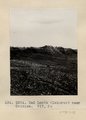 | Bad Lands (Dolores) near Chinlee. VII, 26 (Photo G271) | P0013 Herbert E. Gregory Photograph Collection | P0013n05_66_0778 |
| 719 |  | Shinarump Unconformity, Chinlee. VII, 26 (Photo G272) | P0013 Herbert E. Gregory Photograph Collection | P0013n05_67_0779 |
| 720 |  | Edna's Needle, LaPlata, west of Chinlee. VII, 29 (Photo G274) | P0013 Herbert E. Gregory Photograph Collection | P0013n05_67_0780 |
| 721 | 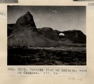 | General view of LaPlata, west of Chinlee. VII, 29 (Photo G273) | P0013 Herbert E. Gregory Photograph Collection | P0013n05_67_0781 |
| 722 |  | Erosion on column, LaPlata, west of Chinlee. VII, 33 (Photo G275) | P0013 Herbert E. Gregory Photograph Collection | P0013n05_68_0782 |
| 723 | 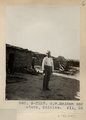 | G.W. McAdam and store, Chinlee. VII, 26 (Photo N-M127) | P0013 Herbert E. Gregory Photograph Collection | P0013n05_68_0783 |
| 724 |  | Dolores shales and marls, 2± mi. above Round Rock store on Carriso Creek at Plue Point (Pish-dot-klish-is-a). VII, 40 (Photo G276) | P0013 Herbert E. Gregory Photograph Collection | P0013n05_68_0784 |
| 725 |  | Bed (9), section of Dolores and LaPlata west of Chinlee. VII, 28 (Photo G277) | P0013 Herbert E. Gregory Photograph Collection | P0013n05_69_0785 |