|
|
Title | Collection Number And Name | Photo Number |
| 651 |
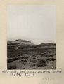
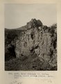
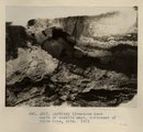 | Tertiary limestone near mouth of Tsebito wash, northeast of White Cone, AZ. 1911 (Photo G222) | P0013 Herbert E. Gregory Photograph Collection | P0013n05_31_0721 |
| 652 |
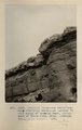 | Tertiary limestone unconformably overlaying sandstone (McElmo?) near mouth of Tsebito wash, northeast of White Cone, AZ (Tusayan topographic sheet). 1911 (Photo G223) | P0013 Herbert E. Gregory Photograph Collection | P0013n05_32_0722 |
| 653 |
 | Jetty-to Springs, Mesa Verde sandstone on Mancos shale. 1911 (Photo G224) | P0013 Herbert E. Gregory Photograph Collection | P0013n05_33_0723 |
| 654 |
 | Jetty-to Springs, Mesa Verde sandstone on Mancos shale. 1911 (Photo G224) | P0013 Herbert E. Gregory Photograph Collection | P0013n05_33_0723 |
| 655 |
 | McElmo-Dakota unconformity southwest of Jetty-to. 1911 (Photo N-M124) | P0013 Herbert E. Gregory Photograph Collection | P0013n05_33_0724 |
| 656 |
 | Jetty-to Springs, Mesa Verde sandstone on Mancos shale. 1910 (Photo G225) | P0013 Herbert E. Gregory Photograph Collection | P0013n05_34_0725 |
| 657 |
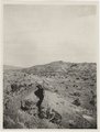
 | Bad Lands, Dolores. Lower Pueblo Colorado Wash. Section VI, 79-80. 1911 (Photo G226) | P0013 Herbert E. Gregory Photograph Collection | P0013n05_35_0726 |
| 658 |
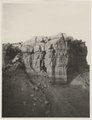
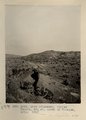
 | Bad Lands. Dolores. Butte No. 24. VI, 76 (Photo G227) | P0013 Herbert E. Gregory Photograph Collection | P0013n05_35_0727 |
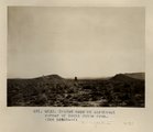
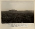
| 659 |
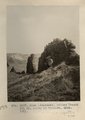
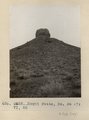 | Moqui Butte, No. 36, VI, 82 (Photo G228) | P0013 Herbert E. Gregory Photograph Collection | P0013n05_36_0728 |
| 660 |
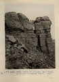
 | Moqui Butte No. 23. VI, 75 (Photo G229) | P0013 Herbert E. Gregory Photograph Collection | P0013n05_36_0729 |
| 661 |
 | Moqui Butte No. 23, VI, 75 (Photo G230) | P0013 Herbert E. Gregory Photograph Collection | P0013n05_37_0730 |
| 662 |
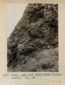 | Ash and tuff near Biddehoche. VI, 84 (Photo G231) | P0013 Herbert E. Gregory Photograph Collection | P0013n05_37_0731 |
| 663 |
 | Bedded ash, 2± mi. south of Cedar Springs. VI, 73 (2) (Photo G232) | P0013 Herbert E. Gregory Photograph Collection | P0013n05_37_0732 |
| 664 |
 | Eroded neck at northwest corner of Moqui Butte area (Photo G233) | P0013 Herbert E. Gregory Photograph Collection | P0013n05_38_0733 |
| 665 |
 | Eroded neck at northwest corner of Moqui Butte area (Photo G233) | P0013 Herbert E. Gregory Photograph Collection | P0013n05_38_0733 |
| 666 |
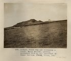 | Round Top and Montezuma's Chair. Moqui BUttes. Looking southwest from 5± mi. southwest of Cedar Springs. Heald, photo. 1911 (Photo N-M125) | P0013 Herbert E. Gregory Photograph Collection | P0013n05_39_0734 |
| 667 |
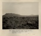 | General view, Moqui Buttes, Biddehoche Section. Barrows, photo. 1911 (Photo G234) | P0013 Herbert E. Gregory Photograph Collection | P0013n05_40_0735 |
| 668 |
 | Dike (diabase?), Stiles Ranche, Moqui Buttes region, AZ. 1911 (Photo G235) | P0013 Herbert E. Gregory Photograph Collection | P0013n05_40_0736 |
| 669 |
 | Dike (diabase?), Stiles Ranche, Moqui Buttes region, AZ. 1911 (Photo G235) | P0013 Herbert E. Gregory Photograph Collection | P0013n05_41_0736 |
| 670 |
 | Dike (diabase), Stiles Ranche, 30± mi. north of Winslow, AZ. 1911 (Photo G236) | P0013 Herbert E. Gregory Photograph Collection | P0013n05_41_0737 |
| 671 |
 | Dike (diabase), Stiles Ranche, 30± mi. north of Winslow, AZ. 1911 (Photo G236) | P0013 Herbert E. Gregory Photograph Collection | P0013n05_42_0737 |
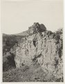
| 672 |
 | Dike (diabase), Stiles Ranche 30± mi. north of Winslow, AZ. 1911 (Photo G237) | P0013 Herbert E. Gregory Photograph Collection | P0013n05_43_0738 |
| 673 |
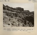
 | Butte, 3± mi. west of Stiles Ranche (Photo G238) | P0013 Herbert E. Gregory Photograph Collection | P0013n05_43_0739 |
| 674 |
 | Butte, 3± mi. west of Stiles Ranche (Photo G238) | P0013 Herbert E. Gregory Photograph Collection | P0013n05_44_0739 |
| 675 |
 | General view, Moqui Buttes region, Cedar Springs area. Barrows, photo. 1911 (Photo G239) | P0013 Herbert E. Gregory Photograph Collection | P0013n05_45_0740 |