| | Title | Collection Number And Name | Photo Number |
|---|
| 551 | 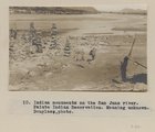 | Indian monuments on the San Juan river. Paiute Indian Reservation. Meaning unknown. Douglass, photo. | P0013 Herbert E. Gregory Photograph Collection | P0013n03_82_0510 |
| 552 | 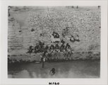 | Native American ritual bath (?) | P0013 Herbert E. Gregory Photograph Collection | P0013n03_H160 |
| 553 | 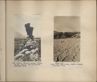 | Herbert E. Gregory Book 4: Navajo, San Juan, 1910 | P0013 Herbert E. Gregory Photograph Collection | P0013n04 |
| 554 |  | San Francisco Mountain (Photo N-M83a) | P0013 Herbert E. Gregory Photograph Collection | P0013n04_17_0541 |
| 555 |  | Agathla and Slim (Queen) Rock, Ariz., from S.E. (Photo N-M86) | P0013 Herbert E. Gregory Photograph Collection | P0013n04_20_0547 |
| 556 | 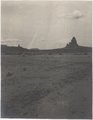 | Agathla and Slim (Queen) Rock, Ariz., from S.E. (Photo G144) | P0013 Herbert E. Gregory Photograph Collection | P0013n04_21_0548 |
| 557 |  | Agathla and Slim (Queen) Rock, Ariz., from S.E. (Photo G144) | P0013 Herbert E. Gregory Photograph Collection | P0013n04_21_0548 |
| 558 |  | Agathla, volcanic neck, between Chinlee, Ariz. and Oljato, Utah, 1910 (Photo G145) | P0013 Herbert E. Gregory Photograph Collection | P0013n04_21_0549 |
| 559 |  | Agathla, volcanic neck, between Chinlee, Ariz. and Oljato, Utah, 1910 (Photo G145) | P0013 Herbert E. Gregory Photograph Collection | P0013n04_21_0549 |
| 560 | 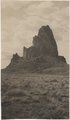 | Agathla, volcanic neck, between Chinlee, Ariz. and Oljato, Utah, 1910 (Photo G146) | P0013 Herbert E. Gregory Photograph Collection | P0013n04_22_0550 |
| 561 |  | Agathla, volcanic neck, between Chinlee, Ariz. and Oljato, Utah, 1910 (Photo G146) | P0013 Herbert E. Gregory Photograph Collection | P0013n04_22_0550 |
| 562 | 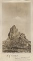 | Agathla (John Wetherill photo) | P0013 Herbert E. Gregory Photograph Collection | P0013n04_22verso_0551 |
| 563 |  | Agathla, volcanic neck, between Chinlee, Ariz. and Oljato, Utah, 1910 (same as G145, Townsend photo) | P0013 Herbert E. Gregory Photograph Collection | P0013n04_23_0552 |
| 564 |  | Cha-ez Kla. (No. 4). Volcanic neck or dike, 2+ mi, south of Agathla Needle, Ariz., 1910 (Photo G147) | P0013 Herbert E. Gregory Photograph Collection | P0013n04_24_0553 |
| 565 | 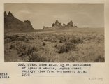 | Dike no. 3, 6+ mi. southeast of Agathla Needle, Laguna Creek valley, view from southeast, Ariz., 1910 (Photo G148) | P0013 Herbert E. Gregory Photograph Collection | P0013n04_24_0554 |
| 566 | 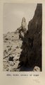 | Detail of dike 6 mi. SE of Agathla Needle, Laguna Creek valley, 1910 (Photo G149) | P0013 Herbert E. Gregory Photograph Collection | P0013n04_25_0555 |
| 567 | 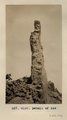 | Detail of dike 6 mi. SE of Agathla Needle, Laguna Creek valley, 1910 (Photo G150) | P0013 Herbert E. Gregory Photograph Collection | P0013n04_25_0556 |
| 568 | 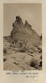 | Detail of dike 6 mi. SE of Agathla Needle, Laguna Creek valley, 1910 (Photo G151) | P0013 Herbert E. Gregory Photograph Collection | P0013n04_26_0557 |
| 569 | 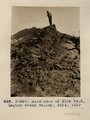 | Dike east of Dike no. 2, Laguna Creek valley, Ariz., 1910 (Photo N-M87) | P0013 Herbert E. Gregory Photograph Collection | P0013n04_26_0558 |
| 570 | 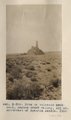 | Dike or volcanic neck no. 2, Laguna Creek valley, 10+ mi. southeast of Agathla Needle, 1910 (Photo NM88) | P0013 Herbert E. Gregory Photograph Collection | P0013n04_27_0559 |
| 571 | 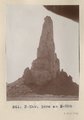 | Dike or volcanic neck no. 2, Laguna Creek valley, 10+ mi. southeast of Agathla Needle, 1910 (Photo NM89) | P0013 Herbert E. Gregory Photograph Collection | P0013n04_27_0560 |
| 572 |  | Dike or volcanic neck no. 2, Laguna Creek valley, 10+ mi. southeast of Agathla Needle, 1910 (Photo by C.C. Colville) | P0013 Herbert E. Gregory Photograph Collection | P0013n04_28_0561 |
| 573 | 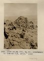 | Dike no. 4A 2+ mil. southeast of Cha-ez Kla, Ariz., 1910. | P0013 Herbert E. Gregory Photograph Collection | P0013n04_28_0562 |
| 574 |  | Slim Rock or "the Queen," LaPlata outlier on Dolores, near Agathla Needle, Ariz., looking southwest, 1910 (Photo G152) | P0013 Herbert E. Gregory Photograph Collection | P0013n04_29_0563 |
| 575 |  | Slim Rock or "the Queen," LaPlata outlier on Dolores, near Agathla Needle, Ariz., looking southwest, 1910 (Photo G152) | P0013 Herbert E. Gregory Photograph Collection | P0013n04_29_0563 |