|
|
Title | Collection Number And Name | Photo Number |
| 1 |
 |
Gordon Miller, University of Utah faculty | P0305 University of Utah Archives Photograph Collection - A-Fa. | A-Fa.MillerGordon. |
| 2 |
 |
George Thomas, University of Utah president | P0305 University of Utah Archives Photograph Collection - A-Fa. Presidents | A-Fa.Thomas. |
| 3 |
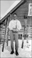 |
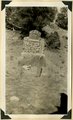
Junior Bounous holding an award. | P0004 Wasatch Mountain Club Photograph Collection | P0004n0017 |
| 4 |
 |
Herbert E. Gregory Book 11: Colorado Plateau, 1938-1942 | P0013 Herbert E. Gregory Photograph Collection | P0013n11 |
| 5 |
 |
East Creek Valley, Union Pacific pump house | P0013 Herbert E. Gregory Photograph Collection | P0013n11_105_2697 |
| 6 |
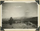 |
Erosion of Cretaceous beds in Paria Valley east of Tropic; Wasatch formation on horizon. View looking east near mouth of Henderson Valley. Garfield County, UT. 1940 | P0013 Herbert E. Gregory Photograph Collection | P0013n11_107_2698 |
| 7 |
 |
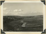
'White Throne' remnant of Navajo sandstone in branch of Paria River. Kane County, UT, 1940 | P0013 Herbert E. Gregory Photograph Collection | P0013n11_108_2699 |
| 8 |
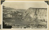 |
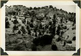
View looking east across north end of No Man's Mesa, composed of Navajo sandstone partly capped by Carmel limestone. Park Wash (foreground) area drained by Kitchen Canyon tributary to Paria River (middle background). Panoramic with no. 887. Kane County, UT, 1940 | P0013 Herbert E. Gregory Photograph Collection | P0013n11_109_2700 |
| 9 |
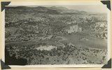 |
Junction of Deer Range and Bullrush Canyons. Highland of Navajo sandstone (upper left), Park Wash lower left: Panoramic with no. 2700. Kane County, UT, 1940 | P0013 Herbert E. Gregory Photograph Collection | P0013n11_109_2701 |
| 10 |
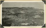 |
Junction of Deer Range and Bullrush Canyons. Highland of Navajo sandstone (upper left), Park Wash lower left: Panoramic with no. 2700. Kane County, UT, 1940 | P0013 Herbert E. Gregory Photograph Collection | P0013n11_110_2702 |
| 11 |
 |
Tomb of Elija Averett, killed by Indians (1866) Averett Wash. Kane County, UT, 1940 | P0013 Herbert E. Gregory Photograph Collection | P0013n11_111_2703 |
| 12 |
 |
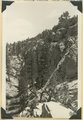
Sheep Creek at head of box canyon. Navajo sandstone (foreground) followed by Carmel and Entrada. Kane County, UT, 1940 | P0013 Herbert E. Gregory Photograph Collection | P0013n11_113_2704 |
| 13 |
 |
Gypsum bed, Curtis overlying Entrada, Averett Wash | P0013 Herbert E. Gregory Photograph Collection | P0013n11_114_2705 |
| 14 |
 |
Fault, Navajo sandstone (right), Carmel formation (left), head of box canyon in Lick Wash. Kane County, UT, 1940 | P0013 Herbert E. Gregory Photograph Collection | P0013n11_115_2706 |
| 15 |
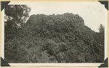 |
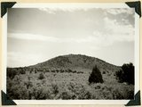
Scoriaceous material near vent of volcanic Black Knoll | P0013 Herbert E. Gregory Photograph Collection | P0013n11_117_2707 |
| 16 |
 |
Bald Knoll Volcanic Cone near head of Johnson Creek. Kane County, UT. 1940 | P0013 Herbert E. Gregory Photograph Collection | P0013n11_118_2708 |
| 17 |
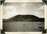 |
Bald Knoll Volcanic Cone near head of Johnson Creek. Kane County, UT. 1940 | P0013 Herbert E. Gregory Photograph Collection | P0013n11_118_2709 |
| 18 |
 |
Eroded edge of basalt flow from Bald Knoll. White Cliffs, Navajo sandstone (upper right); middle Johnson Canyon. Kane County, UT, 1940 | P0013 Herbert E. Gregory Photograph Collection | P0013n11_120_2710 |
| 19 |
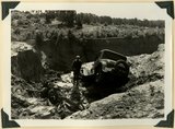 |
Car washed into a ravine by flood. Skutumpah-Swallow Park road | P0013 Herbert E. Gregory Photograph Collection | P0013n11_121_2711 |
| 20 |
 |
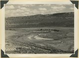
Wilson Peak, head of Hillsdale Canyon. Wasatch limestone overlying the Kaiparowits formation. Garfield County, UT, 1940 | P0013 Herbert E. Gregory Photograph Collection | P0013n11_123_2711 |
| 21 |
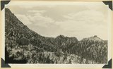 |
View in Hillsdale Gap in Sunset Cliffs looking east; along a fault masses of Wasatch (center and right) are dropped below corresponding beds (upper left). Garfield County, UT, 1940 | P0013 Herbert E. Gregory Photograph Collection | P0013n11_124_2712 |
| 22 |
 |
Sevier River Valley north of Hatch, UT | P0013 Herbert E. Gregory Photograph Collection | P0013n11_124_2713 |
| 23 |
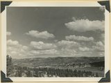 |
View eastward from mouth of Castle Wash, upper Sevier River (foreground) and alluvial fans (center), to Cretaceous and Tertiary beds in Sunset Cliffs (background). Kane County, UT, 1940 | P0013 Herbert E. Gregory Photograph Collection | P0013n11_125_2714 |
| 24 |
 |
Meanders of Sevier River | P0013 Herbert E. Gregory Photograph Collection | P0013n11_125_2715 |
| 25 |
 |
Erosion remnants in upper (white) part of Wasatch formation: limestone and conglomerate. Castle Wash an upper tributary to Sevier River. Kane County, UT, 1940 | P0013 Herbert E. Gregory Photograph Collection | P0013n11_126_2716 |