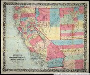
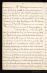
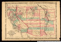
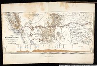
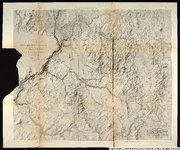
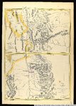
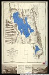
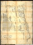
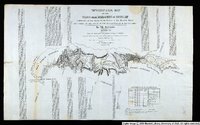
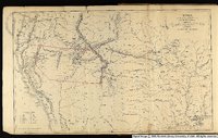
1 - 100 of 63
Number of results to display per page
TitleDateType
1 American Westward Migration historical artifacts: Calligraphy pensImage/MovingImage
2 American Westward Migration historical artifacts: Kesler rulerImage/MovingImage
3 American Westward Migration historical artifacts: Locomotive Engineer HatImage/MovingImage
4 American Westward Migration historical artifacts: SilverwareImage/MovingImage
5 American Westward Migration historical artifacts: Silverware boxImage/MovingImage
6 Bancroft's map of California, Nevada, Utah and Arizona1864Image
7 Diary of B. H. Roberts, 1882 - 18831882; 1883Text
8 Diary of B. H. Roberts, 1884 - 18851884; 1885Text
9 Diary of B. H. Roberts, 1886 - 18871886; 1887Text
10 Diary of B. H. Roberts, 1890 - 18931890; 1891; 1892; 1893Text
11 Diary of Bathsheba W. Bigler Smith1849Text
12 Diary of Frederick Kesler Transcript, 18421842Text
13 Diary of Frederick Kesler, 18421842Text
14 Diary of Frederick Kesler, 1859 - 18741859; 1860; 1861; 1862; 1863; 1864; 1865; 1866; 1867; 1868; 1869; 1870; 1871; 1872; 1873; 1874Text
15 Diary of Frederick Kesler, 1874 - 18771874; 1875; 1876; 1877Text
16 Diary of Frederick Kesler, 1877 - 18811877; 1878; 1879; 1880; 1881Text
17 Diary of Frederick Kesler, 1881 - 18851881; 1882; 1883; 1884; 1885Text
18 Diary of Frederick Kesler, 1885 - 18881885; 1886; 1887; 1888Text
19 Diary of Frederick Kesler, 1888 - 18901888; 1889; 1890Text
20 Diary of Frederick Kesler, 1890 - 18931890; 1891; 1892; 1893Text
21 Diary of Frederick Kesler, 1893 - 18961893; 1894; 1895; 1896Text
22 Diary of Frederick Kesler, 1896 - 18981896; 1897; 1898Text
23 Diary of Frederick Kesler, 1898 - 18991898; 1899Text
24 Diary of George A. Thomas1852; 1853; 1854; 1855; 1856; 1857; 1858; 1859; 1860; 1861; 1862; 1863; 1864; 1865; 1866; 1867; 1868Text
25 Diary of John Boylston Fairbanks1838; 1846; 1847Text
26 Diary of Joseph A. Young1864Text
27 Diary of Joseph C. Kingsbury1846; 1847; 1848; 1849; 1850; 1851; 1852; 1853; 1854; 1855; 1856; 1857; 1858; 1859; 1860; 1861; 1862; 1863; 1864; 1865; 1866; 1867; 1868; 1869; 1870; 1871; 1872; 1873; 1874; 1875; 1876; 1877; 1878; 1879; 1880; 1881; 1882; 1883; 1884; 1885; 1886; 1887; 1888; 1889; 1890; 1891; 1892; 1893Text
28 Diary of Lucia Eugenia Lamb Everett1862Text
29 Great Salt Lake City surveys platted for Cap. Richard F. Burton. by Bullock, Thomas.1860Image/StillImage
30 Johnson's California, with Utah, Nevada, Colorado, New Mexico, and Arizona.1864Image/StillImage
31 Karte zu Balduin Mollhausen's Reise vom Mississippi nach der Kuste der Sudsee im Jahre 1853-18541854Image/StillImage
32 Map Exhibiting the Lines of March Passed Over by the Troops of the United States During the Year Ending June 30th 18581858Image
33 Map exhibiting the lines of march passed over by the troops of the United States during the year ending June 30th 1858.1858Image/StillImage
34 Map exhibiting the routes between Fort Dalles and the Great Salt Lake.1859Image/StillImage
35 Map no. 2, from the Great Salt Lake to the Humboldt Mountains.1855Image/StillImage
36 Map no. 2, from the mouth of Trap Creek to the Santa Fe crossing.1855Image/StillImage
37 Map No. 2, Riviere des Lacs to the Rocky Mountains.1854Image/StillImage
38 Map no. 3 from the Santa Fe crossing to the Coo-Che-to-pa Pass.1855Image/StillImage
39 Map no. 3, Rocky Mountains to Puget Sound.1855Image/StillImage
40 Map of an exploring expedition to the Rocky Mountains in the year 1842 and to Oregon & North California in the years 1843-41845Image/StillImage
41 Map of an exploring expedition to the Rocky Mountains in the year 1842 and to Oregon & North California in the years 1843-441845Image/StillImage
42 Map of explorations and surveys in New Mexico and Utah1860Image/StillImage
43 Map of the Great Salt Lake and adjacent country in the Territory of Utah ; The Great Salt Lake (Mormon) City and surrounding country : (on an enlarged scale)1863Image/StillImage
44 Map of the Great Salt Lake and adjacent country in the territory of Utah.1850Image/StillImage
45 Map of the Great Salt Lake and adjacent country in the territory of Utah.1852Image/StillImage
46 Map of the Territory of New Mexico1850Image/StillImage
47 Map of the Territory of New Mexico made by order of Brig. Gen. S.W. Kearny, under instructions from Lieut. W.H. Emory1848Image/StillImage
48 Map of wagon routes in Utah Territory explored and opened by Capt. J. H. Simpson...in 1858-59.1859Image/StillImage
49 Map showing the different routes travelled over by the detachments of the Overland Command in the spring of 1855 from Salt Lake City, Utah, to the Bay of San Francisco.1855Image/StillImage
50 Map showing the extent of surveys in the territory of Utah, 1856.1856Image/StillImage
51 New map of the state of California, the territories of Oregon, Washington, Utah & New Mexico.1853Image/StillImage
52 Preliminary Map of Routes Reconnoitered and Opened in the Territory of Utah1858Image/StillImage
53 Preliminary map of routes reconnoitered and opened in the Territory of Utah by Capt. J. H. Simpson, Corps of Topographical Engineers, in the fall of 1858, under the orders of Bvt. Brigadier General A.S. Johnston, commanding the Department of Utah.1858Image/StillImage
54 Sketch of the country between South Pass and the Great Salt Lake.1857Image/StillImage
55 Territories of New Mexico and Utah.1855Image/StillImage
56 Topographical Map of the Road From Missouri To Oregon Commencing at the Mouth of the Kansas in the Missouri River and Ending at the Mouth of the Wallah-Wallah in the Columbia. Section 11846Image/StillImage
57 Topographical Map of the Road From Missouri To Oregon Commencing at the Mouth of the Kansas in the Missouri River and Ending at the Mouth of the Wallah-Wallah in the Columbia. Section 21846Image/StillImage
58 Topographical Map of the Road From Missouri To Oregon Commencing at the Mouth of the Kansas in the Missouri River and Ending at the Mouth of the Wallah-Wallah in the Columbia. Section 31846Image/StillImage
59 Topographical Map of the Road From Missouri To Oregon Commencing at the Mouth of the Kansas in the Missouri River and Ending at the Mouth of the Wallah-Wallah in the Columbia. Section 41846Image/StillImage
60 Topographical Map of the Road From Missouri To Oregon Commencing at the Mouth of the Kansas in the Missouri River and Ending at the Mouth of the Wallah-Wallah in the Columbia. Section 51846Image/StillImage
61 Topographical Map of the Road From Missouri To Oregon Commencing at the Mouth of the Kansas in the Missouri River and Ending at the Mouth of the Wallah-Wallah in the Columbia. Section 61846Image/StillImage
62 Topographical Map of the Road From Missouri To Oregon Commencing at the Mouth of the Kansas in the Missouri River and Ending at the Mouth of the Wallah-Wallah in the Columbia. Section 71846Image/StillImage
63 Utah and the Overland Routes to it from the Missouri River1855Image/StillImage
1 - 100 of 63