|
|
Title | Creator | Creation Date |
| 1 |
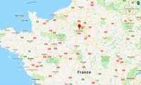 |
Map: Paris and Versailles, France | | |
| 2 |
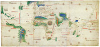 |
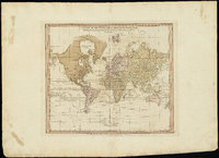
Cantino Planisphere | unknown | 1502 CE |
| 3 |
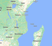 |
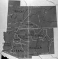
Map: Makonde people were in contemporary Kenya, Tanzania, and Mozambique | | |
| 4 |
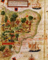 |
Terra Brasilis (detail) | Lopo Homem; Pedro Reinel; Jorge Reinel | 1515 - 1519 CE |
| 5 |
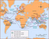 |
Map: Dutch Trade Routes | | |
| 6 |
 |
New World Map | Diogo Homem | 1568 CE |
| 7 |
 |
Map: Nigeria in West Africa | | |
| 8 |
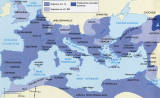 |
Map: The Roman Empire | | |
| 9 |
 |
Map: Locations of 1937 Paris World's Fair, the Berlin Olympics, Nuremberg Rallies, and Great German and Degenerate Art Exhibits | | |
| 10 |
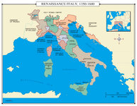 |
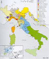
Map: Renaissance Italy 1350 - 1600 CE | | |
| 11 |
 |
Map: Europe, 1648 CE | | |
| 12 |
 |
Map: Aztec Empire in 1518 CE | | 1518 CE |
| 13 |
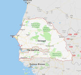 |
Map: Senegal | | |
| 14 |
 |
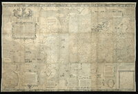
A chart of the world upon Mercator's projection : describing the tracks of Capt. Cook in the year 1768, 69, 70, 71, and in 1772, 73, 74, 75, with the new discoveries | William Faden | 1775 CE |
| 15 |
 |
A new plan of ye great town of Boston in New England in America, with the many additionall [sic] buildings, & new streets, to the year, 1769 | William Price; John Bonner | 1769 CE |
| 16 |
 |
Map: The Empire on the Eve of the French Revolution, 1789 | | |
| 17 |
 |
Map: The greatest extent of Napoleon I's First Empire, 1812 | | |
| 18 |
 |
Map: Osogbo | | |
| 19 |
 |
Map: Mediterranean and Northern Africa | | |
| 20 |
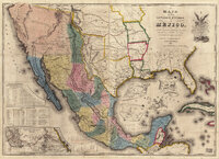 |
Map of the United States of Méjico (Mexico) | John Disturnell | 1846 CE |
| 21 |
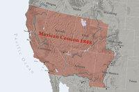 |
Map: Mexican Cession 1848 | | |
| 22 |
 |
Map: The Hohenstaufen Empire under Frederick II | | |
| 23 |
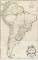 |
Amerique Meridionale Publiee sous les Auspices de Monseigneur le Duc d'Orleans | Jean Baptiste Bourguignon D'Anville | 1748 CE |
| 24 |
 |
Mercator world map of 1569 (Nova et Aucta Orbis Terrae Descriptio ad Usum Navigantium Emendate Accommodata) | Gerardus Mercator | 1569 CE |
| 25 |
 |
Map: Minoan Crete and the Bronze Age Aegean | | |
| 26 |
 |
Map: The Greek World | | |
| 27 |
 |
Map: Prehistoric Europe and the Near East | | |
| 28 |
 |
Map: Ancient Near East | | |
| 29 |
 |
Map: Australia | | |
| 30 |
 |
Map: Pompeii in 79 CE | | |
| 31 |
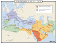 |
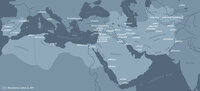
Map: Spread of Islam, 622-750 CE | | 622 - 750 CE |
| 32 |
 |
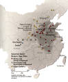
Map: Kiln Sites of China | | |
| 33 |
 |
Map: Pueblo Cultures in the American Southwest | | |
| 34 |
 |
Map: China and Korea, showing Neolithic and Bronze Age sites | | |
| 35 |
 |
A Plan of the Town of New Haven with all the Buildings in 1748 | William Lyon | 1748 CE |
| 36 |
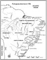 |
Map: Portuguese America in 1750 | | 1750 CE |
| 37 |
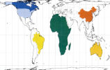 |
Peters Projection Map of the World | Dr. Arno Peters | 1974 CE |
| 38 |
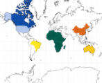 |
Mercator's Map of the World | Gerardus Mercator | 1538 CE |
| 39 |
 |
Map: Approximate Spheres and Succession of the Xia, Shang, and Zhou Dynasties | | |
| 40 |
 |
Map: East Coast Prehistoric Cultures | | |
| 41 |
 |
Map: China during the Spring and Autumn Period | | |
| 42 |
 |
Map: The Han Empire and the Silk Road | | |
| 43 |
 |
Map: East Asia, circa 715 CE | | |
| 44 |
 |
Map: East Asia, circa 615 CE | | |
| 45 |
 |
Map: Asia circa 450 CE | | 450 CE |
| 46 |
 |
Map: Asia circa 850 CE | | 850 CE |
| 47 |
 |
Map: Asia circa 1250 CE | | 1250 CE |
| 48 |
 |
Map: Principal Sites of Ancient Egypt | | |
| 49 |
 |
Map: Ancient Egypt | | |
| 50 |
 |
Map: The Roman Empire in the Second Century CE | | 2nd Century CE |
| 51 |
 |
Map: The Byzantine Empire circa 1000 CE | | 1000 CE |
| 52 |
 |
Map: Europe, about 1100 CE | | 1100 CE |
| 53 |
 |
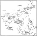
Map: Borobudur and Kedu Plain | | |
| 54 |
 |
Map: Buddhist Asia | | |
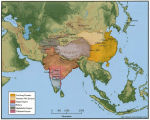
| 55 |
 |
Map: Route of Mansa Musa's hajj | | |
| 56 |
 |
Map: Trans Saharan Trade and Sea Routes | | |
| 57 |
 |
Atlas of Maritime Charts (The Catalan Atlas), detail showing Mansa Musa | possibly Abraham Cresques | 1375 CE |
| 58 |
 |
Atlas of Maritime Charts (The Catalan Atlas) | possibly Abraham Cresques | 1375 CE |
| 59 |
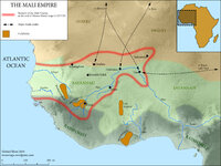 |
Map: The Mali Empire | | 1312 - 1337 CE |
| 60 |
 |
Map: Spread of Buddhism, ca. 200-900 CE | | ca. 200 - 900 CE |
| 61 |
 |
Map: The Silk Roads, ca. 200-900 CE | | ca. 200 - 900 CE |
| 62 |
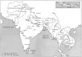 |
Map: Buddhist Sites in India, Neighboring Regions, and Southeast Asia | | |
| 63 |
 |
Map: Buddhist World Showing the Main Pilgrimmage and Trade Routes | | |
| 64 |
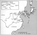 |
Map: Buddhist Sites in China, Central Asia, Korea, and Japan | | |
| 65 |
 |
Map: Latin America around the year 1500, with the principal native societies and the three empires: Aztec, Mayan, and Incan | | |
| 66 |
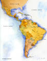 |
Map: Latin America Political Map | | |
| 67 |
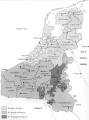 |
Map: Flemish / Dutch Lowlands, 1585 - 1700 | | |
| 68 |
 |
Map: Early Bronze Age Sites in China | | |
| 69 |
 |
Map: Han Empire | | |
| 70 |
 |
Map: Important Archaeological Sites of the Erlitou culture period | | 19th - 16th Century BCE |
| 71 |
 |
Map: Major Sites of the Eastern Zhou Dynasty | | |
| 72 |
 |
Map: Major Sites of the Shang Dynasty, Erligang Culture | | |
| 73 |
 |
Map: Major sites in Rome, Italy | | |
| 74 |
 |
Map: Umayyad Emirate, c. 850 CE, Umayyad Caliphate, c. 950 CE | | |
| 75 |
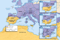 |
Map: Decline of Muslim Rule in the Iberian Peninsula that culminated in the Reconquista, Inquisition, and the rise of Spanish and Portuguese kingdoms, 1000-1300 CE | | |
| 76 |
 |
Map: Europe during the 14th Century CE | | 14th Century CE |
| 77 |
 |
Map: British Empire, excluding Americas, 1921 CE | | 1921 CE |
| 78 |
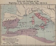 |
Map: Roman and Carthaginian Territories at the beginning of the Second Punic War, 218 BCE | | 218 BCE |
| 79 |
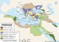 |
Map: Extent of Ottoman Empire, 1300-1699 CE | | 1300 - 1699 CE |
| 80 |
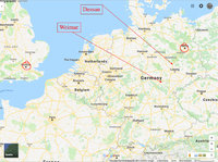 |
Map: Northern Europe showing Dessau and Weimar, Germany | | |
| 81 |
 |
Map: Florence, Italy, 1400 CE | | |
| 82 |
 |
Map: Italy, c.1410 CE | | |
| 83 |
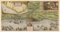 |
Map of the Dutch capture of the town of Olinda in Pernambuco by the Dutch West Indies Company in February 1630 | | 1630 CE |
| 84 |
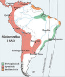 |
Map: South America around 1650 | | 1650 CE |
| 85 |
 |
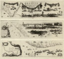
Map: Brazil | | |
| 86 |
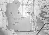 |
Map: Northen Great Salt Lake Area | | |
| 87 |
 |
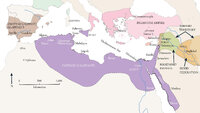
Map: Abbasid caliphate | | |
| 88 |
 |
Map showing Ravenna and Aachen | | |
| 89 |
 |
Map showing the dissolution of the former Roman Empire, c. 600 | | c. 600 CE |
| 90 |
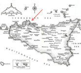 |
Map: Sicily | | |
| 91 |
 |
Map: Cairo and environs during Fatimid period | | |
| 92 |
 |
Map: Cairo and environs during Fatimid period | | |
| 93 |
 |
Map: Fatimid Caliphate Rule | | |
| 94 |
 |
Map: Fatimid Caliphate Rule | | |
| 95 |
 |
New Hydrographic and Geographic Map of Brazil, containing the Provinces of Ciriji, with Itapuama in Paranambuca, Itamaraca, Paraiba, and Potigi to the Rio Grande | Georg Marcgraf; Johan Blaeu (engraver) | 1643 CE |
| 96 |
 |
Map of America | attributed to Diogo Ribeiro | c. 1532 CE |
| 97 |
 |
Map: Areas in northeast Brazil occupied by the Dutch, showing the main regions under Johan Maurits van Nassau's rule, 1637 - 1644 | | |
| 98 |
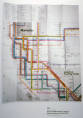 |
New York Metropolitan Transit Authority Subway Guide | Massimo Vignelli | 1970 CE |
| 99 |
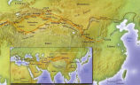 |
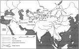
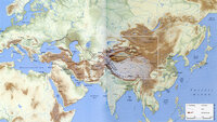
Map: The Silk Road | | |
| 100 |
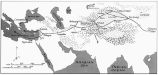 |
Map: Ancient Silk Routes between China and the West | | |