|
|
Title | Creator | Creation Date |
| 126 |
 |
Brasilia, Congress Complex | Oscar Niemeyer | 1958 - 1960 CE |
| 127 |
 |
Brasilia, Congress Complex | Oscar Niemeyer | 1958 - 1960 CE |
| 128 |
 |
Juscelino Kubitschek with Lucio Costa, in 1957, at the center of the Pilot Plan to be built, Brasilia | | 1957 CE |
| 129 |
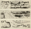 |
New Hydrographic and Geographic Map of Brazil, containing the Provinces of Ciriji, with Itapuama in Paranambuca, Itamaraca, Paraiba, and Potigi to the Rio Grande | Georg Marcgraf; Johan Blaeu (engraver) | 1643 CE |
| 130 |
 |
Map of America | attributed to Diogo Ribeiro | c. 1532 CE |
| 131 |
 |
The Island of Brazil (2) | Anonymous | c. 1550 CE |
| 132 |
 |
The Island of Brazil (1) | Anonymous | c. 1550 CE |
| 133 |
 |
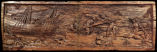
Sugar Mill (detail) | Frans Post | 1660s CE |
| 134 |
 |
Sugar Mill | Frans Post | 1660s CE |
| 135 |
 |
Ruins of the Jesuit Church in Olinda | Frans Post | 1660s CE |
| 136 |
 |
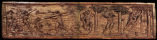
Ruins of Olinda (detail) | Frans Post | 1666 CE |
| 137 |
 |
Ruins of Olinda | Frans Post | 1666 CE |
| 138 |
 |
Map: Areas in northeast Brazil occupied by the Dutch, showing the main regions under Johan Maurits van Nassau's rule, 1637 - 1644 | | |
| 139 |
 |
Portrait of Johan Maurits van Nassau-Siegen | Anonymous | 1647 CE |
| 140 |
 |
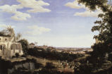
View of the Church of Glória | Nicolas Antoine Taunay | |
| 141 |
 |
View of the Sugar Loaf | Nicolas Antoine Taunay | |
| 142 |
 |
Tapuias Indians, Manaus | Albert Frisch | c. 1865 CE |
| 143 |
 |
King João VI and Queen Carlota Joaquina on Quinta da Boa Vista | Nicolas Antoine Taunay | |
| 144 |
 |
Indians of Amazonas | Albert Frisch | c. 1865 CE |
| 145 |
 |
Slaves of the Naturalist | Jean Baptiste Debret | |
| 146 |
 |
Inhabitant of Minas Crossing a River | Jean Baptiste Debret | |
| 147 |
 |
Maritime View of Rio de Janeiro | Nicolas Antoine Taunay | |
| 148 |
 |
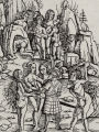
Amazons | André de Thevet | 1557 CE |
| 149 |
 |
Amazons | Amerigo Vespucci | 1509 CE |
| 150 |
 |
Serro Frio: Two Overseers Search a Slave (or Whipping an Enslaved Male) | Carlos Julião | ca. 1780 CE |