|
|
Title | Date | Type |
| 1 |
 |
1849-1850 Annual Report of the Commissioner of Indian Affairs. | 1849 | Text |
| 2 |
 |
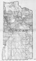
2010 Boundary Validation Program_001 | | Image/StillImage |
| 3 |
 |
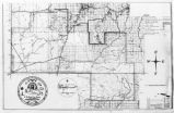
2010 Boundary Validation Program_002 | | Image/StillImage |
| 4 |
 |
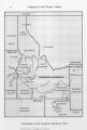
2010 Boundary Validation Program_003 | | Image/StillImage |
| 5 |
 |
2010 Boundary Validation Program_004 | | Image/StillImage |
| 6 |
 |
2010 Boundary Validation Program_005 | | Image/StillImage |
| 7 |
 |
2010 Boundary Validation Program_006 | | Image/StillImage |
| 8 |
 |
A History of the Uintah-Ouray Ute Lands | 1979 | Text |
| 9 |
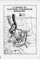 |
A Theory of Southern Athabascan Migration | | Image/StillImage |
| 10 |
 |
Agreement of 1880 | | Text |
| 11 |
 |
Annual Report of the Commissioner of Indian Affairs - 1874 | 1874 | Image/StillImage |
| 12 |
 |
Annual Report of the Commissioner of Indian Affairs - 1875 | | Text |
| 13 |
 |
Annual Report of the Commissioner of Indian Affairs - 1876 | 1876 | Text |
| 14 |
 |
Annual Report of the Commissioner of Indian Affairs - 1877 | 1877 | Text |
| 15 |
 |
Annual Report of the Commissioner of Indian Affairs - 1878 | 1878 | Image/StillImage |
| 16 |
 |
Annual Report of the Commissioner of Indian Affairs - 1880 | 1880 | Text |
| 17 |
 |
Annual Report of the Commissioner of Indian Affairs - 1881 | 1881 | Text |
| 18 |
 |
Annual Report of the Commissioner of Indian Affairs - 1882 | 1882 | Image/StillImage |
| 19 |
 |
Annual Report of the Commissioner of Indian Affairs - 1883 | 1883 | Text |
| 20 |
 |
Annual Report of the Commissioner of Indian Affairs - 1884 | 1884 | Text |
| 21 |
 |
Annual Report of the Commissioner of Indian Affairs - 1885 | 1885 | Text |
| 22 |
 |
Annual Report of the Commissioner of Indian Affairs - 1898 | 1898 | Image/StillImage |
| 23 |
 |
Annual Report of the Commissioner of Indian Affairs - 1902 (Pt II) | 1902 | Text |
| 24 |
 |
Annual Report of the Commissioner of Indian Affairs - 1903 (Pt I) | 1903 | Text |
| 25 |
 |
Annual Report of the Commissioner of Indian Affairs - 1903 (Pt II) | 1903 | Text |
| 26 |
 |
Annual Report of the Commissioner of Indian Affairs - 1904 (Pt I) | 1904 | Text |
| 27 |
 |
Annual Report of the Commissioner of Indian Affairs - 1905 (Pt II) | 1905 | Text |
| 28 |
 |
Annual Report of the Commissioner of Indian Affairs - 1906 | 1906 | Text |
| 29 |
 |
Annual Report of the Commissioner of Indian Affairs - 1907 | 1907 | Text |
| 30 |
 |
Annual Report of the Commissioner of Indian Affairs - 1908 | 1908 | Text |
| 31 |
 |
Annual Report of the Commissioner of Indian Affairs - 1909 | 1909 | Text |
| 32 |
 |
Annual Report of the Commissioner of Indian Affairs - 1910 | 1910 | Text |
| 33 |
 |
Annual Report of the Commissioner of Indian Affairs - 1911 | 1911 | Text |
| 34 |
 |
Annual Report of the Commissioner of Indian Affairs - 1912 | 1912 | Text |
| 35 |
 |
Annual Report of the Commissioner of Indian Affairs - 1913 | 1913 | Text |
| 36 |
 |
Annual Report of the Commissioner of Indian Affairs - 1914 | 1914 | Text |
| 37 |
 |
Annual Report of the Commissioner of Indian Affairs - 1915 | 1915 | Text |
| 38 |
 |
Annual Report of the Commissioner of Indian Affairs - 1916 | 1916 | Text |
| 39 |
 |
Annual Report of the Commissioner of Indian Affairs - 1917 | 1917 | Text |
| 40 |
 |
Annual Report of the Commissioner of Indian Affairs - 1921 | 1921 | Text |
| 41 |
 |
Annual Report of the Commissioner of Indian Affairs - 1924 | 1924 | Text |
| 42 |
 |
Annual Report of the Commissioner of Indian Affairs - 1925 | 1925 | Text |
| 43 |
 |
Annual Report of the Commissioner of Indian Affairs - 1926 | 1926 | Text |
| 44 |
 |
Annual Report of the Commissioner of Indian Affairs - 1927 | 1927 | Text |
| 45 |
 |
Annual Report of the Commissioner of Indian Affairs - 1928 | 1928 | Text |
| 46 |
 |
Annual Report of the Commissioner of Indian Affairs - 1929 | 1929 | Text |
| 47 |
 |
Annual Report of the Commissioner of Indian Affairs -1923 | 1923 | Text |
| 48 |
 |
Annual Report of the Commissioner of Indian Affairs to the Secretary of the Interior for the Fiscal Year Ending June 30, 1922 | 1922 | Text |
| 49 |
 |
Annual Reports of the Department of the Interior for the Fiscal Year Ending June 30, 1905 (Pt I) | 1905 | Text |
| 50 |
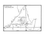 |
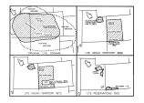
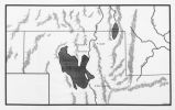
Area of the Allen Canyon Utes | | Image/StillImage |
| 51 |
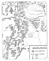 |
Black Hawk War 1865-72 | | Image/StillImage |
| 52 |
 |
Boundary of Shoshone Indian Territory | 1957 | Image/StillImage |
| 53 |
 |
Boundary of Shoshone Indian Territory according to Swanton, 1952 | 1952 | Image/StillImage |
| 54 |
 |
Boundary of Shoshone Indian Territory and Neighboring Tribes | 1957 | Image/StillImage |
| 55 |
 |
Boundary of Shoshone Indian Territory, Linguistic Boundaries of Shoshone and Bannock. | 1941 | Image/StillImage |
| 56 |
 |
Boundary of Shoshone Indian Territory, showing the locations of the Bannock | 1957 | Image/StillImage |
| 57 |
 |
Boundary of Shoshone Indian Territory, showing the locations of the Bannock from 1819 to 1951 | 1957 | Image/StillImage |
| 58 |
 |
Boundary of Shoshone Indian Territory, showing the locations where the Bannock and Shoshone reported together 1819-1956 | 1957 | Image/StillImage |
| 59 |
 |
Boundary of Shoshone Indian Territory; Doty Map of 1863 Indian Claims Commission | 1957 | Image/StillImage |
| 60 |
 |
Bureau of Indian Affairs | | Image/StillImage |
| 61 |
 |
Changes of Ute Territory 1868-1972 | | Text |
| 62 |
 |
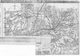
Early Roads and Railroads circa 1895 | | Image/StillImage |
| 63 |
 |
Father Escalante's Map | 1941 | Text |
| 64 |
 |
Field Notes from Survey of Uintah Reservation | 1875-09-25 | Text |
| 65 |
 |
The Ghost dance Religion and the Sioux | | Text |
| 66 |
 |
Goshute Indian Reservation Nevada and Utah | | Image/StillImage |
| 67 |
 |
Goshute Skull Valley Reservation Geothermal Resources Map | 2004-01-14 | Image/StillImage |
| 68 |
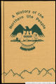 |
History of the Northern Ute People, A | 1982 | Text |
| 69 |
 |
Indian Names in Utah Geography | 1928; 1929; 1930; 1931; 1932; 1933 | Text |
| 70 |
 |
Journal of Two Campaigns by the Utah Territorial Militia Against the Navajo Indians, 1869 | 1961 | Text |
| 71 |
 |
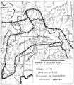
Land Added to Confederated Ute Indian Reservation 1875-76 | | Text |
| 72 |
 |
Land Allotments, White Mesa | | Image/StillImage |
| 73 |
 |
Letter from Agent Byrnes to Commissioner of Indian Affairs John D.C. Atkins dated November 28, 1887 | 1887-11-28 | Text |
| 74 |
 |
Letter from Agent Robert Waugh to Commissioner of Indian Affairs T.J. Morgan dated July 30, 1892 | 1892-07-30 | Text |
| 75 |
 |
Letter from Brigham Young to the Commissioner of Indian Affairs dated June 28, 1853 | 1853-06-28 | Text |
| 76 |
 |
Letter to Commissioner of Indian Affairs J.T. Morgan from Agent Robert Waugh dated March 28, 1892 | 1892-03-28 | Text |
| 77 |
 |
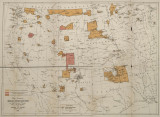
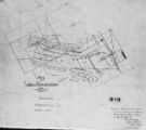
Map of a portion of the Uncompahgre Ute Indian Reservation | 1908 | Image/StillImage |
| 78 |
 |
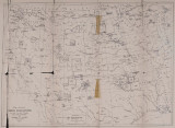
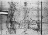
Map of a portion of the Uncompahgre Ute Indian Reservation, surveyed and subdivided for allotments to the Uncompahgre Ute Indians in accordance with the Act approved June 1880 by authority of Honorable N. C. McFarland, Commissioner General Land Office Daniel G. Major U.S. Surveyor 1882-1883 | 1882; 1883 | Image/StillImage |
| 79 |
 |
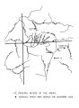
Map of Chief Washakie's Hunting and Fighting Territory, prepare by Oscar Mosserly, 1930 | | Image/StillImage |
| 80 |
 |
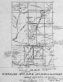
Map of Dry Gulch Irrigation District, Uintah Indian Reservation, Utah | | Image/StillImage |
| 81 |
 |
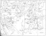
Map of East Central Utah, Uintah Ouray Reservation, Utah Valley | | Image/StillImage |
| 82 |
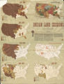 |
Map of Indian Land Cessions in the United States | | Image/StillImage |
| 83 |
 |
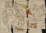
Map of Indian Reservation in the West, 1929 | | Image/StillImage |
| 84 |
 |
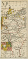
Map of Indian Reservation. 1884 | | Image/StillImage |
| 85 |
 |
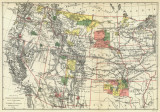
Map of Indian Reservations in the Western United States | | Image/StillImage |
| 86 |
 |
Map of Indian Territory in the Western United States | | Image/StillImage |
| 87 |
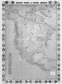 |
Map of Indian Tribes of North America | | Image/StillImage |
| 88 |
 |
Map of Navajo, Ute, and Jicarilla Apache Indian Reserves | | Image/StillImage |
| 89 |
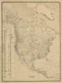 |
Map of North America and Original Inhabitants' Territory. | | Image/StillImage |
| 90 |
 |
Map of Northern Utah, Early Settlements | | Image/StillImage |
| 91 |
 |
Map of Part of the West Boundary of the Uncompahgre Ute Indian Reservation as Surveyed by William B. Dougall | | Image/StillImage |
| 92 |
 |
Map of Reservations of the Western United States and the Religions that Worked on the Reservations 1870's | 1873 | Image/StillImage |
| 93 |
 |
Map of Shoshone Indian Territory, and the Division of Shoshone Boundaries in Nevada | | Image/StillImage |
| 94 |
 |
Map of Shoshone Territory; Prepared by Doty, 1859 | | Image/StillImage |
| 95 |
 |
Map of Southern Colorado and the Ute Mountain Ute Reservation | | Image/StillImage |
| 96 |
 |
Map of Southern Ute Agencies | | Image/StillImage |
| 97 |
 |
Map of Stock Mining Claims in the Uintah Basin | | Image/StillImage |
| 98 |
 |
Map of the Four Corners Region and the Reservation of the Ute Mountain Ute Tribe | | Image/StillImage |
| 99 |
 |
Map of the Homelands of Northern Shoshone, 1863 | | Image/StillImage |
| 100 |
 |
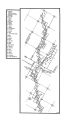
Map of the Northern Part of the Former Uintah Indian Reservation Showing the Irrigation System | | Image/StillImage |