Home
Browse
Ask Us
Chat
Harmful Language Statement
Log in
Theses & Dissertations
Advanced Search
Year
1935
1936
1937
1938
1939
1940
1941
1942
1943
1944
1945
1946
1947
1948
1949
1950
1951
1952
1953
1954
1955
1956
1957
1958
1959
1960
1961
1962
1963
1964
1965
1966
1967
1968
1969
TO
1935
1936
1937
1938
1939
1940
1941
1942
1943
1944
1945
1946
1947
1948
1949
1950
1951
1952
1953
1954
1955
1956
1957
1958
1959
1960
1961
1962
1963
1964
1965
1966
1967
1968
1969
School Or College
College of Mines & Earth Sciences
2
College of Engineering
1
College of Science
1
College of Social & Behavioral Science
1
Department
Geology & Geophysics
2
Biological Sciences
1
Geography
1
Mechanical Engineering
1
Publication Type
thesis
5
Subject
Bryce Canyon National Park (Utah)
1
Cannel coal
1
Cattle
1
Coal trade, Utah
1
Coal, Utah
1
Ecology
1
Erosion
1
Erosion -- Utah -- Bryce Canyon National Park
1
Escalante Utah
1
Geology -- Utah -- Bryce Canyon National Park
1
Sheep
1
More
Filters:
Collection:
"ir_etd"
1
-
25
of
27
<
1
2
>
Gallery view
Number of results to display per page
10
25
50
100
200
Sort by Relevance
Sort by Title A-Z
Sort by Title Z-A
Sort by Date Ascending
Sort by Date Descending
Sort by Last Modified Ascending
Sort by Last Modified Descending
Author
Title
Subject
Date
Publication Type
1
Figure 3: Map of Long Valley showing the Parunuweap Formation, Orderville gravel, and basalt flows
2
Figure 4: Map of the Virgin River valley showing the Parunuweap Formation, Orderville gravel, and basalt flows
3
Page 204
4
Page 92
5
Figure 3 Map of Long Valley showing the Parunuweap Formation, Orderville gravel, and basalt flows (Google Earth map overlay KMZ file)
6
Page 48
7
Figure 4 Map of the Virgin River valley showing the Parunuweap Formation, Orderville gravel, and basalt flows (Google Earth map overlay KMZ file)
8
Page 256
9
Page 125
10
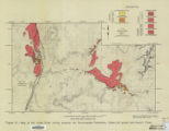
Plate1 Geologic and topographic map of the Coal Hill area, Kane County, Utah
11
Page 144
12
Page 18
13
Page 147
14
Page 21
15
Page 25
16
Page 89
17
Page 95
18
Page 97
19
Page 115
20
Page 81
21
Dalness, William Michael
Parunuweap formation in the vicinity of Zion National Park, Utah
1969-06
thesis
22
Page 76
23
Page 85
24
Jacobsen, Samuel Clark; Carter, G.W.
Engineering factors relating to the utilization of the cannel coals of southern Utah
Cannel coal; Coal, Utah
1935-05
thesis
25
Hall, Heber H.
The impact of man on the vegetation and soil of the Upper Valley Allotment Garfield County, Utah
Escalante Utah; Cattle; Sheep; Erosion; Ecology
1954
thesis
1
-
25
of
27
<
1
2
>