Home
Browse
Ask Us
Chat
Harmful Language Statement
Log in
Theses & Dissertations
Advanced Search
Year
1954
1955
1956
1957
1958
1959
1960
1961
1962
1963
1964
1965
1966
1967
1968
1969
1970
1971
1972
TO
1954
1955
1956
1957
1958
1959
1960
1961
1962
1963
1964
1965
1966
1967
1968
1969
1970
1971
1972
School Or College
College of Mines & Earth Sciences
20
Department
Geology & Geophysics
16
Mining Engineering
4
Publication Type
thesis
20
Subject
Thesis and dissertation georeferencing project
3
Geology -- Utah -- Juab County -- Tintic Mining District
1
Geology -- Utah -- Morgan County
1
Geology -- Utah -- Ogden Valley
1
Geology -- Utah -- Summit County
1
Groundwater -- Utah -- Ogden Valley
1
More
Filters:
Collection:
"ir_etd"
Type:
"Image"
1
-
25
of
21
Gallery view
Number of results to display per page
10
25
50
100
200
Sort by Relevance
Sort by Title A-Z
Sort by Title Z-A
Sort by Date Ascending
Sort by Date Descending
Sort by Last Modified Ascending
Sort by Last Modified Descending
Author
Title
Subject
Date
Publication Type
1
Blakey, Ronald Clyde
Plate 2: Structural sections
1970-08
thesis
2
Blakey, Ronald Clyde
Plate 3: Structural sections
1970-08
thesis
3
Rodriguez, Enrique Levy
Plate 1: Geologic map and vertical cross section of the Sulphurdale sulphur deposits, Beaver and Millard Counties, Utah
1960-08
thesis
4
Sadeghi, Ali Reza
Plate 1: Geologic map of the Willard Peak area, North-Central Wasatch Mountains, Utah
1972-12
thesis
5
Rodriguez, Enrique Levy
Plate 2: Detailed geologic and vertical cross sections map of the Excelsior Orebody and New York Prospect Pit, Millard County, Utah
1960-08
thesis
6
Neff, Thomas Rodney
Plate 2: Sections along line A-A' and B-B'
1962-11
thesis
7
Sadeghi, Ali Reza
Plate 2: Structure sections for geologic map of the Willard Peak area
1972-12
thesis
8
Sadeghi, Ali Reza
Plate 3: Palinspastic middle and upper Cambrian columnar sections from western and northern Utah
1972-12
thesis
9
Rodriguez, Enrique Levy
Plate 4: Detailed map showing diamond drill hole locations and vertical cross sections of the Sulphurdale Orebody, Beaver County, Utah
1960-08
thesis
10
Neff, Thomas Rodney
Plate 1: Geologic map of the Little Willow Series, Wasatch Mountains, Utah
1962-11
thesis
11
Blakey, Ronald Clyde
Plate 1: Geologic map of the Paria NW quadrangle, Kane County, Utah
1970-08
thesis
12
Rodriguez, Enrique Levy
Plate 3: Detailed geologic and vertical cross section map of the Prince Albert Orebody, Mariposa and Queen Victoria Prospect Pits, Millard County, Utah
1960-08
thesis
13
Neff, Thomas Rodney
Plate 3: Structural map of the Little Willow Series, Wasatch Mountains, Utah
1962-11
thesis
14
Blakey, Ronald Clyde
Plate 3: Structural map of the Paria NW quadrangle, Kane County, Utah
1970-08
thesis
15
Sadeghi, Ali Reza
Plate 4: Correlation of Precambrian rocks of the lower plate and upper plate of the Willard thrust with the Huntsville and Cottonwood areas
1972-12
thesis
16
Neff, Thomas Rodney
Plate 4: Map variations of the Little Willow Series, Wasatch Mountains, Utah
1962-11
thesis
17
Blakey, Ronald Clyde
Plate 4: Topographic features of the Paria NW quadrangle, Kane County, Utah
1970-08
thesis
18
Plate1 Geologic map of the Northern Golden Gate range, Northern Nye and Lincoln Counties, Nevada
19
Madsen, James Henry Jr.
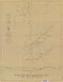
Geology of the Lost Creek-Echo Canyon Area, Morgan and Summit Counties, Utah
Geology -- Utah -- Morgan County; Geology -- Utah -- Summit County; Thesis and dissertation georeferencing project
1959-06
thesis
20
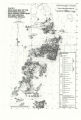
Gardner, Weston Clive
Geology of the West Tintic mining district and vicinity, Juab County, Utah
Geology -- Utah -- Juab County -- Tintic Mining District; Thesis and dissertation georeferencing project
1954-06
thesis
21
Doyuran, Vedat
Geology and ground-water resources of Ogden Valley, Utah
Geology -- Utah -- Ogden Valley; Groundwater -- Utah -- Ogden Valley; Thesis and dissertation georeferencing project
1972-06
thesis
1
-
25
of
21