TO
1 - 25 of 24
| Author | Title | Subject | Date | Publication Type | ||
|---|---|---|---|---|---|---|
| 1 |
 |
Figure 37 Generalized topographic and structural map of the Grassy Mountain - Lakeside Mountain area, Utah (Google Earth map overlay KMZ file) | Geology -- Utah -- Tooele County; Geology -- Utah -- Box Elder County; Geology -- Utah -- Grassy Mountains -- Maps; Geology -- Utah -- Lakeside Mountains -- Maps | |||
| 2 |
|
Figure 38 Northern Utah Highland showing probable structures related to paleocene uplift (Google Earth map overlay KMZ file) | Geology -- Utah -- Tooele County; Geology -- Utah -- Box Elder County; Geology -- Utah -- Grassy Mountains -- Maps; Geology -- Utah -- Lakeside Mountains -- Maps | |||
| 3 |
 |
Harrill, James Reece | Geology of the Davis Knolls and northern Big Davis Mountain area, Tooele County, Utah | Geology -- Utah -- Tooele County; Thesis and dissertation georeferencing project | 1962-08 | thesis |
| 4 |
 |
Harrill, James Reece | Geology of the Davis Knolls and northern Big Davis Mountain area, Tooele County, Utah (Google Earth map overlay KMZ file) | Geology -- Utah -- Tooele County; Thesis and dissertation georeferencing project | 1962-08 | map |
| 5 |
 |
Harrill, James Reece | Geology of the Davis Knolls and northern Big Davis Mountain area, Tooele County, Utah: Georeferenced map files | Geology -- Utah -- Tooele County | 1962-08 | thesis |
| 6 |
 |
Doelling, Hellmut H. | Geology of the Northern Lakeside Mountains and the Grassy Mountains and vicinity, Tooele and Box Elder Counties, Utah | Geology -- Utah -- Tooele County; Geology -- Utah -- Box Elder County; Geology -- Utah -- Grassy Mountains -- Maps; Geology -- Utah -- Lakeside Mountains -- Maps | 1964-06 | thesis |
| 7 |
|
Doelling, Hellmut H. | Geology of the Northern Lakeside Mountains and the Grassy Mountains and vicinity, Tooele and Box Elder Counties, Utah (Google Earth map overlay KMZ file) | Geology -- Utah -- Tooele County; Geology -- Utah -- Box Elder County; Geology -- Utah -- Grassy Mountains -- Maps; Geology -- Utah -- Lakeside Mountains -- Maps; Thesis and dissertation georeferencing project | 1964-06 | map |
| 8 |
|
Doelling, Hellmut H. | Geology of the Northern Lakeside Mountains and the Grassy Mountains and vicinity, Tooele and Box Elder Counties, Utah: Georeferenced map files | Geology -- Utah -- Tooele County; Geology -- Utah -- Box Elder County; Geology -- Utah -- Grassy Mountains -- Maps; Geology -- Utah -- Lakeside Mountains -- Maps | 1964-06 | thesis |
| 9 |
 |
Cohenour, Robert E. | Geology of the Sheeprock Mountains, Tooele and Juab Counties, Utah | Geology -- Utah -- Sheeprock Mountains; Geology -- Utah -- Tooele County; Geology -- Utah -- Juab County; Thesis and dissertation georeferencing project | 1957-08 | thesis |
| 10 |
|
Cohenour, Robert E. | Geology of the Sheeprock Mountains, Tooele and Juab Counties, Utah: Georeferenced map files | Geology -- Utah -- Sheeprock Mountains; Geology -- Utah -- Tooele County; Geology -- Utah -- Juab County | 1957-08 | thesis |
| 11 |
|
Map 1 Geologic map of the Northern Lakeside Mountains, Box Elder County, Utah (Google Earth map overlay KMZ file) | Geology -- Utah -- Tooele County; Geology -- Utah -- Box Elder County; Geology -- Utah -- Grassy Mountains -- Maps; Geology -- Utah -- Lakeside Mountains -- Maps | |||
| 12 |
|
Map 2 Geologic map of the Grassy Mountains, Box Elder and Tooele Counties, Utah (Google Earth map overlay KMZ file) | Geology -- Utah -- Tooele County; Geology -- Utah -- Box Elder County; Geology -- Utah -- Grassy Mountains -- Maps; Geology -- Utah -- Lakeside Mountains -- Maps | |||
| 13 |
|
Map 3 Geologic map of Puddle Valley and the Central Lakeside Mountains (Google Earth map overlay KMZ file) | Geology -- Utah -- Tooele County; Geology -- Utah -- Box Elder County; Geology -- Utah -- Grassy Mountains -- Maps; Geology -- Utah -- Lakeside Mountains -- Maps | |||
| 14 |
|
Map 4 Geologic map of Grayback Mountain and Grassy Ridge, Tooele County, Utah (Google Earth map overlay KMZ file) | Geology -- Utah -- Tooele County; Geology -- Utah -- Box Elder County; Geology -- Utah -- Grassy Mountains -- Maps; Geology -- Utah -- Lakeside Mountains -- Maps | |||
| 15 |
|
Part1 Geology of the Davis Knolls and northern Big Davis Mountain area, Tooele County, Utah | Geology -- Utah -- Tooele County | |||
| 16 |
 |
Part2 Geology of the Davis Knolls and northern Big Davis Mountain area, Tooele County, Utah | Geology -- Utah -- Tooele County | |||
| 17 |
 |
Part3 Geology of the Davis Knolls and northern Big Davis Mountain area, Tooele County, Utah | Geology -- Utah -- Tooele County | |||
| 18 |
 |
Part4 Geology of the Davis Knolls and northern Big Davis Mountain area, Tooele County, Utah | Geology -- Utah -- Tooele County | |||
| 19 |
|
Cohenour, Robert E. | Plate 1 Geologic map of the Sheeprock Mountains area, Utah (Google Earth map overlay KMZ file) | Geology -- Utah -- Sheeprock Mountains; Geology -- Utah -- Tooele County; Geology -- Utah -- Juab County; Thesis and dissertation georeferencing project | 1957-08 | thesis |
| 20 |
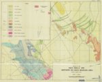 |
Plate1 Geology of the Davis Knolls and northern Big Davis Mountain area | Geology -- Utah -- Tooele County | |||
| 21 |
|
Plate1 Geology of the Davis Knolls and northern Big Davis Mountain area (Google Earth map overlay KMZ file) | Geology -- Utah -- Tooele County | |||
| 22 |
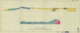 |
Plate2 Geologic cross sections Davis Knolls and northern Big Davis Mountain area | Geology -- Utah -- Tooele County | |||
| 23 |
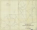 |
Plate3 Map showing locations of fossil localities and measured sections in the Davis Knolls and northern Big Davis Mountain area, Tooele County, Utah | Geology -- Utah -- Tooele County | |||
| 24 |
|
Plate3 Map showing locations of fossil localities and measured sections in the Davis Knolls and northern Big Davis Mountain area, Tooele County, Utah (Google Earth map overlay KMZ file) | Geology -- Utah -- Tooele County |
1 - 25 of 24