TO
| Author | Title | Subject | Date | Publication Type | ||
|---|---|---|---|---|---|---|
| 1 |
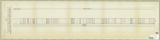 |
Mourer, Robert E. | Columnar section of the permian unnamed formation exposed between Rydalch Pass and US Coast and geodetic survey Cedar Triangulation Station Plate VIII | Geologic cross-sections; Rydalch Pass; Cedar Triangulation Station | Columnar Section | |
| 2 |
 |
Forrester, John B. | Concerning the Laramie Formation in Carbon County, Utah | Geology - Utah - Carbon County; Coal mines and mining - Utah; Geology, Stratigraphic - Cretaceous | 1905 | thesis |
| 3 |
 |
E. Clarence Schmutz | Oil reserves in the oil shale and coal deposits of Utah | Petroleum; Geology; Economics | 1905-04-15 | thesis |
| 4 |
 |
Kemmerer, John L. Jr. | Gilsonite | Gilsonite; Geology, Uintah Basin (Utah and Colo.) | 1905-04-17 | thesis |
| 5 |
 |
Fox, Feramorz Y. | General features of the Wasatch Mountains | Geology - Utah - Wasatch Range; Wasatch Range (Utah and Idaho) | 1906 | thesis |
| 6 |
 |
Nokes, Charles Mormon | The Igneous Rocks of Utah | Igneous rocks - Utah | 1912 | thesis |
| 7 |
 |
Pack, Mosher Franklin | Report on some building stones submitted for the Utah capitol | Building stones -- Utah -- Salt Lake City | 1912 | thesis |
| 8 |
 |
Amin, Surendra R. | Map 1: Geologic map of Antelope intrusive and vicinity | 1950 | thesis | |
| 9 |
 |
Amin, Surendra R. | Map 1: Geologic map of Antelope intrusive and vicinity (Google Earth map overlay KMZ file) | Thesis and dissertation georeferencing project | 1950 | map |
| 10 |
 |
Amin, Surendra R | Heavy mineral study of the intrusive rocks of the Antelope Range, Piute County, Utah | Mineralogy--Utah; Marysvale, Utah--Mining; Uranium mining; Thesis and dissertation georeferencing project | 1950 | thesis |
| 11 |
 |
O'Toole, Walter L. | Geology of the Keetley-Kamas volcanic area: Georeferenced map files | Geology; Utah; Summit County; Wasatch County | 1951 | thesis |
| 12 |
 |
O'Toole, Walter L. | Geology of the Keetley-Kamas volcanic area | Geology; Utah; Summit County; Wasatch County | 1951 | thesis |
| 13 |
|
Hooper, Warren G. | Geology of the Smith and Morehouse-South Fork Area, Utah: Georeferenced map files | Geology -- Uinta Mountains (Utah and Wyo.) | 1951 | thesis |
| 14 |
|
Hooper, Warren G. | Plate 3 Geologic map of portion of Northwestern Uinta Mountains, Utah (Google Earth map overlay KMZ file) | Geology -- Uinta Mountains (Utah and Wyo.); Thesis and dissertation georeferencing project | 1951 | thesis |
| 15 |
 |
Hooper, Warren G. | Plate 3: Geologic map of portion of Northwestern Uinta Mountains, Utah | 1951 | thesis | |
| 16 |
|
O'Toole, Walter L. | Geology of the Keetley-Kamas volcanic area (Google Earth map overlay KMZ file) | Geology; Utah; Summit County; Wasatch County; Thesis and dissertation georeferencing project | 1951 | map |
| 17 |
 |
Hooper, Warren G | Geology of the Smith and Morehouse-South Fork Area, Utah | Geology -- Uinta Mountains (Utah and Wyo.); Thesis and dissertation georeferencing project | 1951 | thesis |
| 18 |
|
Root, Robert L. | Map1 Geologic map and sections of Smith and Morehouse-Hayden Fork area, Utah (Google Earth map overlay KMZ file) | Geology; Utah; Summit County; Thesis and dissertation georeferencing project | 1952 | thesis |
| 19 |
 |
Root, Robert L. | Geology of the Smith and Morehouse-Hayden Fork area, Utah | Geology; Utah; Summit County; Thesis and dissertation georeferencing project | 1952 | thesis |
| 20 |
 |
Mount, Donald Lee | Geology of the Wanship - Park City Region, Utah | Geology -- Utah -- Summit County | 1952-06 | thesis |
| 21 |
|
Mount, Donald Lee | Plate 3: Geologic map and sections of Wanship-Park City region, Utah (Google Earth map overlay KMZ file) | Geology -- Utah -- Summit County | 1952-06 | thesis |
| 22 |
 |
Mount, Donald Lee | Plate 3: Geologic map and sections of Wanship-Park City region, Utah | 1952-06 | thesis | |
| 23 |
|
Mount, Donald Lee | Geology of the Wanship - Park City Region, Utah: Georeferenced map files | Geology -- Utah -- Summit County | 1952-06 | thesis |
| 24 |
 |
Johnson, Melvin Coatany | Areal geology of the Wanship-Coalville Area | Geology; Utah; Wanship region; Coalville region; Thesis and dissertation georeferencing project | 1952-06 | thesis |
| 25 |
 |
Holt, Robert Eugene | Structure and petrology of the diorite on the 800 level Mayflower Mine, Park City, Utah | petrology; mining | 1953 | thesis |