Containing over 30,000 images, the Classified Photograph Collection is an artificially created collection by Utah Division of State History over a forty year period. Created as a browsing collection, it is organized by subjects of popular interest regarding Utah history.
TO
- Classified Photograph Collection52
- Classified Photograph Collection, 725.1 Public Buildings3
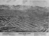
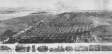
- Classified Photograph Collection, 979.21 Salt Lake City--Panoramic Views3
- Classified Photograph Collection, 359 Naval Supply Depot, Clearfield2
- Classified Photograph Collection, 356 Defense Depot (Ogden & Kearns), SL Army Air Base, Tooele Army Depot, USO1
- More
Filters: Collection: "dha_cp" Subject: "Maps"
1 - 100 of 62


1 - 100 of 62