|
|
Title | Date | Type |
| 1 |
 |
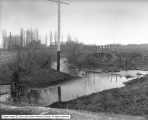
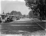
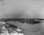
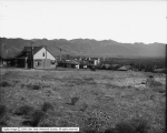
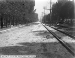
1000 South Canal, Looking East | 1913 | Image |
| 2 |
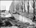 |
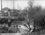
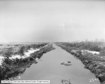
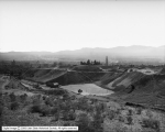
1000 South Canal, Looking West, Dredging of Canal | 1913 | Image |
| 3 |
 |
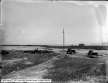
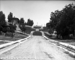
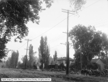
600 East From Liberty Park | 1924 | Image |
| 4 |
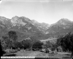 |
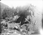
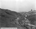
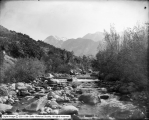
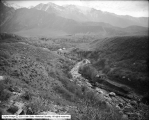
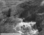
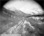
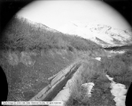
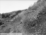
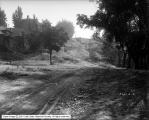
American Fork Canyon | 1907-07-21 | Image |
| 5 |
 |
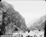
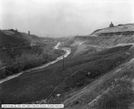
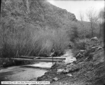
American Fork Canyon | 1907-07-21 | Image |
| 6 |
 |
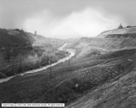
American Fork Canyon | 1907-07-21 | Image |
| 7 |
 |
American Fork Canyon | 1907-07-21 | Image |
| 8 |
 |
American Fork Canyon | 1907-07-21 | Image |
| 9 |
 |
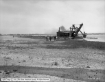
Blasting Channel to Pumping Plant in Utah Lake | 1925 | Image |
| 10 |
 |
Blasting Channel To Pumping Plant in Utah Lake | 1925 | Image |
| 11 |
 |
Center Street, City Cemetery | 1929 | Image |
| 12 |
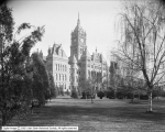 |
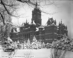
City and County Building | 1910; 1906; 1907; 1908; 1909; 1911; 1912; 1913; 1914 | Image |
| 13 |
 |
City and County Building | 1905 | Image |
| 14 |
 |
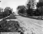
City and County Building | 1902 | Image |
| 15 |
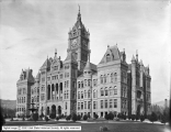 |
City and County Building | 1902 | Image |
| 16 |
 |
City and County Building | 1910; 1906; 1907; 1908; 1909; 1911; 1912; 1913; 1914 | Image |
| 17 |
 |
City and County Building | 1910; 1906; 1907; 1908; 1909; 1911; 1912; 1913; 1914 | Image |
| 18 |
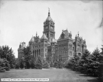 |
City and County Building | 1910; 1906; 1907; 1908; 1909; 1911; 1912; 1913; 1914 | Image |
| 19 |
 |
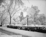
City and County Building | 1914-10-23 | Image |
| 20 |
 |
City and County Building | 1902 | Image |
| 21 |
 |
City and County Building | 1910; 1906; 1907; 1908; 1909; 1911; 1912; 1913; 1914 | Image |
| 22 |
 |
City and County Building | 1902 | Image |
| 23 |
 |
City Creek Aqueduct | 1907; 1903; 1904; 1905; 1906; 1908; 1909; 1910; 1911 | Image |
| 24 |
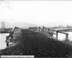
 |
City Creek Aqueduct, Near Canyon Road | 1910 | Image |
| 25 |
 |
City Creek Aqueduct, North Temple and 1100 West | 1909 | Image |
| 26 |
 |
City Creek Aqueduct, North Temple and 1100 West | 1909 | Image |
| 27 |
 |
City Creek Canyon, Showing Bridge Sites | 1920 | Image |
| 28 |
 |
City Creek Canyon, Showing Bridge Sites | 1920 | Image |
| 29 |
 |
Concrete Culvert - City Creek | 1906 | Image |
| 30 |
 |
Concrete Culvert - City Creek | 1906 | Image |
| 31 |
 |
Concrete Culvert - City Creek | 1906 | Image |
| 32 |
 |
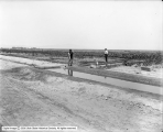
Curb and Gutter - 200 North from West Temple and Quince | 1923-06-28 | Image |
| 33 |
 |
Curb and Gutter - 200 North from West Temple and Quince | 1923-06-28 | Image |
| 34 |
 |
Curb and Gutter Extension - 1300 East, North from 2700 South | 1929 | Image |
| 35 |
 |
Curb and Gutter Extension - 1500 East, South From Parkway | 1929 | Image |
| 36 |
 |
Curb and Gutter Extension No. 58 | 1926 | Image |
| 37 |
 |
Curb and Gutter Extension No. 58 | 1926 | Image |
| 38 |
 |
Curb and Gutter Extension No. 58 | 1926 | Image |
| 39 |
 |
Curb and Gutter Extension No. 58 | 1926 | Image |
| 40 |
 |
Curb and Gutter Extension No. 64 - Dearborn Avenue, South from Parkway Avenue | 1929 | Image |
| 41 |
 |
Curb and Gutter Extension No. 64 - Parkway Avenue, West From Dearborn Avenue | 1929 | Image |
| 42 |
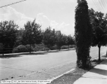
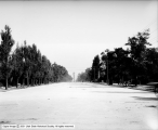
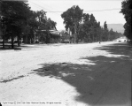
 |
Curb and Gutters - 900 South, East from 1100 East | 1924 | Image |
| 43 |
 |
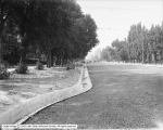
Downington Avenue, East from 600 East - After Paving | 1929-10 | Image |
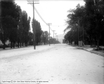
| 44 |
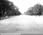
 |
Downington Avenue, East from 600 East - Before Paving | 1929-07 | Image |
| 45 |
 |
Gravity Outlet Sewer | 1907; 1903; 1904; 1905; 1906; 1908; 1909; 1910; 1911 | Image |
| 46 |
 |
Gravity Outlet Sewer | 1910; 1906; 1907; 1908; 1909; 1911; 1912; 1913; 1914 | Image |
| 47 |
 |
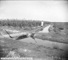
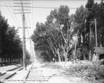
Gravity Outlet Sewer Corn Farmer | 1910; 1906; 1907; 1908; 1909; 1911; 1912; 1913; 1914 | Image |
| 48 |
 |
Gravity Outlet Sewer Gates in Main Ditch | 1910; 1906; 1907; 1908; 1909; 1911; 1912; 1913; 1914 | Image |
| 49 |
 |
Gravity Outlet Sewer Irrigation Ditches | 1910; 1906; 1907; 1908; 1909; 1911; 1912; 1913; 1914 | Image |
| 50 |
 |
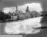
Jordan River | | Image |
| 51 |
 |
Jordan River | | Image |
| 52 |
 |
Jordan River | 1910; 1906; 1907; 1908; 1909; 1911; 1912; 1913; 1914 | Image |
| 53 |
 |
Jordan River | | Image |
| 54 |
 |
Jordan River | | Image |
| 55 |
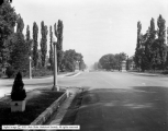
 |
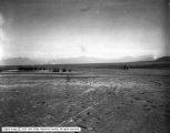
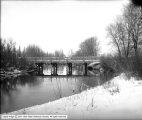
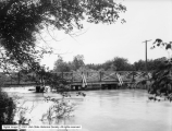
Jordan River - Bridge, 500 South | 1920-05-17 | Image |
| 56 |
 |
Jordan River - High Water, 900 North | 1902 | Image |
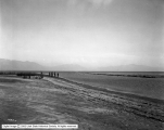
| 57 |
 |
Jordan River - Jordan Narrows | 1908-01-28 | Image |
| 58 |
 |
Jordan River - Jordan Narrows | 1908-01-28 | Image |
| 59 |
 |
Jordan River - Jordan Narrows | 1908-01-28 | Image |
| 60 |
 |
Jordan River - Man in Boat | 1910; 1906; 1907; 1908; 1909; 1911; 1912; 1913; 1914 | Image |
| 61 |
 |
Jordan River - New Dam | | Image |
| 62 |
 |
Jordan River - New Dam | | Image |
| 63 |
 |
Jordan River - South of Plant | 1910; 1906; 1907; 1908; 1909; 1911; 1912; 1913; 1914 | Image |
| 64 |
 |
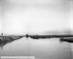
Jordan River - Surplus Canal | 1910-01-20 | Image |
| 65 |
 |
Jordan River - Surplus Canal | 1910-01-20 | Image |
| 66 |
 |
Jordan River - Surplus Canal, Near Saltair | 1916-06-13 | Image |
| 67 |
 |
Jordan River - Wagon | 1910; 1906; 1907; 1908; 1909; 1911; 1912; 1913; 1914 | Image |
| 68 |
 |
Jordan River - Weir | 1910; 1906; 1907; 1908; 1909; 1911; 1912; 1913; 1914 | Image |
| 69 |
 |
Jordan River - Weirs | 1910; 1906; 1907; 1908; 1909; 1911; 1912; 1913; 1914 | Image |
| 70 |
 |
Jordan River Bridge | 1904 | Image |
| 71 |
 |
Jordan River Bridge | 1904 | Image |
| 72 |
 |
Jordan River Bridge | 1904 | Image |
| 73 |
 |
Jordan River Bridge - 700 South | 1907 | Image |
| 74 |
 |
Jordan River Bridge - 800 West | 1907 | Image |
| 75 |
 |
Jordan River Bridge - 900 North | 1908 | Image |
| 76 |
 |
Jordan River Bridge - 900 North | 1908 | Image |
| 77 |
 |
Jordan River Bridge - 900 North | 1908 | Image |
| 78 |
 |
Jordan River Bridge - 900 North | 1908 | Image |
| 79 |
 |
Jordan River Bridge - 900 North | 1908 | Image |
| 80 |
 |
Jordan River Bridge - 900 North | 1908 | Image |
| 81 |
 |
Jordan River Bridge - Flood Bridge at 400 North | 1907 | Image |
| 82 |
 |
Jordan River Pumping Station - Surplus Canal | 1910 | Image |
| 83 |
 |
Jordan River Pumping Station - Surplus Canal | 1910 | Image |
| 84 |
 |
Jordan River Pumping Station - Terrain Near Canal | 1910 | Image |
| 85 |
 |
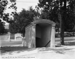
Liberty Park Comfort Station - Exterior | 1917-01-26 | Image |
| 86 |
 |
Little Cottonwood Canyon - Sandy Weir | 1910; 1906; 1907; 1908; 1909; 1911; 1912; 1913; 1914 | Image |
| 87 |
 |
Little Cottonwood Creek - Open Flat, Tents in Distance | 1910; 1906; 1907; 1908; 1909; 1911; 1912; 1913; 1914 | Image |
| 88 |
 |
Mill Creek - Creek | 1910; 1906; 1907; 1908; 1909; 1911; 1912; 1913; 1914 | Image |
| 89 |
 |
Mill Creek - Dirt Road | 1910; 1906; 1907; 1908; 1909; 1911; 1912; 1913; 1914 | Image |
| 90 |
 |
Mill Creek - East Toward Mouth of Canyon | 1910; 1906; 1907; 1908; 1909; 1911; 1912; 1913; 1914 | Image |
| 91 |
 |
Mill Creek - Farming District | 1910; 1906; 1907; 1908; 1909; 1911; 1912; 1913; 1914 | Image |
| 92 |
 |
Mill Creek - Gate | 1910; 1906; 1907; 1908; 1909; 1911; 1912; 1913; 1914 | Image |
| 93 |
 |
Mill Creek - House and Base of Canyon | 1910; 1906; 1907; 1908; 1909; 1911; 1912; 1913; 1914 | Image |
| 94 |
 |
Mill Creek - Ram Bishop | 1910; 1906; 1907; 1908; 1909; 1911; 1912; 1913; 1914 | Image |
| 95 |
 |
Mill Creek - The Divide | 1910; 1906; 1907; 1908; 1909; 1911; 1912; 1913; 1914 | Image |
| 96 |
 |
Mill Creek - Winter, Looking Toward Valley | 1910; 1906; 1907; 1908; 1909; 1911; 1912; 1913; 1914 | Image |
| 97 |
 |
Mouth of City Creek Canyon, Showing Bridge Sites | 1920 | Image |
| 98 |
 |
North Point Dam | 1921-07 | Image |
| 99 |
 |
North Point Dam | 1921-07 | Image |
| 100 |
 |
North Point Dam | 1921-07 | Image |
| 101 |
 |
Parley's Canyon | 1909-05-06 | Image |
| 102 |
 |
Parley's Canyon - Bridge | 1910; 1906; 1907; 1908; 1909; 1911; 1912; 1913; 1914 | Image |
| 103 |
 |
Parley's Canyon - Building | 1910; 1906; 1907; 1908; 1909; 1911; 1912; 1913; 1914 | Image |
| 104 |
 |
Parley's Canyon - Conduit | 1910; 1906; 1907; 1908; 1909; 1911; 1912; 1913; 1914 | Image |
| 105 |
 |
Parley's Canyon - Conduit | 1910; 1906; 1907; 1908; 1909; 1911; 1912; 1913; 1914 | Image |
| 106 |
 |
Parley's Canyon - Dudler's Place | 1910; 1906; 1907; 1908; 1909; 1911; 1912; 1913; 1914 | Image |
| 107 |
 |
Parley's Canyon - Dudler's Place | 1910; 1906; 1907; 1908; 1909; 1911; 1912; 1913; 1914 | Image |
| 108 |
 |
Parley's Canyon - Flume With Water Flowing | 1910; 1906; 1907; 1908; 1909; 1911; 1912; 1913; 1914 | Image |
| 109 |
 |
Parley's Canyon - Flume With Water Flowing | 1909 | Image |
| 110 |
 |
Parley's Canyon - Pleasant View Canal | 1910; 1906; 1907; 1908; 1909; 1911; 1912; 1913; 1914 | Image |
| 111 |
 |
Parley's Canyon - Pleasant View Canal | 1910; 1906; 1907; 1908; 1909; 1911; 1912; 1913; 1914 | Image |
| 112 |
 |
Parley's Canyon - Pleasant View Canal | 1910; 1906; 1907; 1908; 1909; 1911; 1912; 1913; 1914 | Image |
| 113 |
 |
Parley's Canyon - Pleasant View Canal | 1910; 1906; 1907; 1908; 1909; 1911; 1912; 1913; 1914 | Image |
| 114 |
 |
Parley's Canyon - Pleasant View Canal | 1910; 1906; 1907; 1908; 1909; 1911; 1912; 1913; 1914 | Image |
| 115 |
 |
Parley's Canyon - Pleasant View Canal | | Image |
| 116 |
 |
Parley's Canyon - Reservoir | 1908 | Image |
| 117 |
 |
Parley's Canyon - Reservoir | 1908 | Image |
| 118 |
 |
Parley's Canyon - Technicians Working at Reservoir | 1910; 1906; 1907; 1908; 1909; 1911; 1912; 1913; 1914 | Image |
| 119 |
 |
Parley's Canyon - Watchman's Cottage | 1928 | Image |
| 120 |
 |
Parley's Canyon - Watchman's Cottage | 1928 | Image |
| 121 |
 |
Parley's Creek at 900 East, Accidental Drowning of Wayne Ensign | 1928 | Image |
| 122 |
 |
Parley's Creek at 900 East, Site of Accidental Drowning of Wayne Ensign | 1928 | Image |
| 123 |
 |
Parley's Creek Water Supply | 1910; 1906; 1907; 1908; 1909; 1911; 1912; 1913; 1914 | Image |
| 124 |
 |
Parley's Creek Water Supply | 1910; 1906; 1907; 1908; 1909; 1911; 1912; 1913; 1914 | Image |
| 125 |
 |
Pedestrian Subway at South Temple and R Street | 1931 | Image |
| 126 |
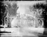 |
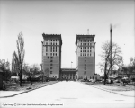
President Harding Welcome Arch | 1923-06-30 | Image |
| 127 |
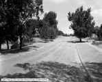 |
Princeton Avenue from 1200 East | 1924 | Image |
| 128 |
 |
Red Butte Hollow - Fill Across Canyon | 1931 | Image |
| 129 |
 |
Red Butte Hollow - Fill, Looking South | 1915 | Image |
| 130 |
 |
Red Butte Hollow - Fill, Looking South | 1915-09-03 | Image |
| 131 |
 |
Red Butte Hollow - Location of Fill Across Canyon | 1915-07-03 | Image |
| 132 |
 |
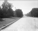
Roosevelt Avenue from 1200 East | 1924 | Image |
| 133 |
 |
Roosevelt Avenue, East From 1200 East | 1924-05-06 | Image |
| 134 |
 |
Salt Lake City - Asphalt Mine Near Thistle, Utah | 1907 | Image |
| 135 |
 |
Salt Lake City - Asphalt Mine Near Thistle, Utah | 1907 | Image |
| 136 |
 |
Salt Lake City - City and County Building | | Image |
| 137 |
 |
Salt Lake City - Panoramic View #1 From North Bench | 1913 | Image |
| 138 |
 |
Salt Lake City - Panoramic View #2 From North Bench | 1913 | Image |
| 139 |
 |
Salt Lake City - Panoramic View #3 From North Bench | 1913 | Image |
| 140 |
 |
Sewer, Pipes | 1910 | Image |
| 141 |
 |
Street Improvement - Sherman Avenue, East from 1300 East Before Improving | 1926 | Image |
| 142 |
 |
Street Improvements - 4th (Fourth) Avenue Stairway | 1915-07-07 | Image |
| 143 |
 |
Street Improvements - 4th (Fourth) Avenue, Looking East from Canyon Road | 1914-09-05 | Image |
| 144 |
 |
Street Paving - 100 West, Between 100 South and South Temple | 1909 | Image |
| 145 |
 |
Street Paving - 100 West, North from 100 South | 1909 | Image |
| 146 |
 |
Street Paving - 100 West, North from 200 South | 1909 | Image |
| 147 |
 |
Street Paving - 100 West, North from 300 South | 1909 | Image |
| 148 |
 |
Street Paving - 200 South, East from 300 East | 1906 | Image |
| 149 |
 |
Street Paving - 300 South, Trees Being Uprooted | 1909 | Image |
| 150 |
 |
Street Paving - 500 East, North from 100 South | 1908 | Image |
| 151 |
 |
Street Paving - 500 East, North from 200 South | 1908 | Image |
| 152 |
 |
Street Paving - 500 East, North from 300 South | 1909 | Image |
| 153 |
 |
Street Paving - 500 East, North from 300 South | 1908 | Image |
| 154 |
 |
Street Paving - 500 East, South from 100 South | 1908 | Image |
| 155 |
 |
Street Paving - 500 East, South from 200 South | 1908 | Image |
| 156 |
 |
Street Paving - 500 East, South from South Temple | 1908 | Image |
| 157 |
 |
Street Paving - 600 East, North from 300 South | 1915 | Image |
| 158 |
 |
Street Paving - 700 East, South from 100 South | 1909 | Image |
| 159 |
 |
Street Paving - 800 South, Between State and Main | 1909 | Image |
| 160 |
 |
Street Paving - Exchange Place | 1909 | Image |
| 161 |
 |
Street Paving - Exchange Place | 1909-05 | Image |
| 162 |
 |
Street Paving - Exchange Place Construction | 1909-04-02 | Image |
| 163 |
 |
Street Paving - F Street | 1908 | Image |
| 164 |
 |
Street Paving - Main Street, Between 400 and 500 South | 1907 | Image |
| 165 |
 |
Street Paving - Main Street, North From 700 South | 1907 | Image |
| 166 |
 |
University Street | 1924 | Image |
| 167 |
 |
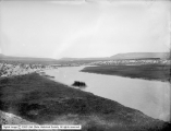
Utah Lake | | Image |
| 168 |
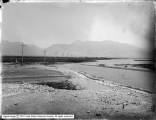 |
Utah Lake | 1910; 1906; 1907; 1908; 1909; 1911; 1912; 1913; 1914 | Image |
| 169 |
 |
Utah Lake - Boat Pier | 1910; 1906; 1907; 1908; 1909; 1911; 1912; 1913; 1914 | Image |
| 170 |
 |
Utah Lake - Boat Tipped on Side, Sheds | 1910; 1906; 1907; 1908; 1909; 1911; 1912; 1913; 1914 | Image |
| 171 |
 |
Utah Lake - Dirt Road Looking East | | Image |
| 172 |
 |
Utah Lake - Farm and Resort | 1910; 1906; 1907; 1908; 1909; 1911; 1912; 1913; 1914 | Image |
| 173 |
 |
Utah Lake - Large Home With Dance Pavilion | 1910; 1906; 1907; 1908; 1909; 1911; 1912; 1913; 1914 | Image |
| 174 |
 |
Utah Lake - Large Home With Dance Pavilion | 1910; 1906; 1907; 1908; 1909; 1911; 1912; 1913; 1914 | Image |
| 175 |
 |
Utah Lake - Man in a Boat Looking East | 1910; 1906; 1907; 1908; 1909; 1911; 1912; 1913; 1914 | Image |
| 176 |
 |
Utah Lake - Resort Seen in Distance | 1910; 1906; 1907; 1908; 1909; 1911; 1912; 1913; 1914 | Image |
| 177 |
 |
Utah Lake - Showing Monument, Spanish Fork Canyon | 1910; 1906; 1907; 1908; 1909; 1911; 1912; 1913; 1914 | Image |
| 178 |
 |
Utah Lake - Valley Area | 1910; 1906; 1907; 1908; 1909; 1911; 1912; 1913; 1914 | Image |
| 179 |
 |
Utah Lake - Valley Area, Farm | 1910; 1906; 1907; 1908; 1909; 1911; 1912; 1913; 1914 | Image |
| 180 |
 |
Utah Lake - Valley Area, Showing a Cabin and Tent | 1910; 1906; 1907; 1908; 1909; 1911; 1912; 1913; 1914 | Image |
| 181 |
 |
Utah Lake Area | | Image |
| 182 |
 |
Utah Lake Area | 1910; 1906; 1907; 1908; 1909; 1911; 1912; 1913; 1914 | Image |
| 183 |
 |
Utah Lake Area | 1910; 1906; 1907; 1908; 1909; 1911; 1912; 1913; 1914 | Image |
| 184 |
 |
Utah Lake Area | 1910; 1906; 1907; 1908; 1909; 1911; 1912; 1913; 1914 | Image |
| 185 |
 |
Utah Lake Area | | Image |
| 186 |
 |
Utah Lake Area - Monument | 1910; 1906; 1907; 1908; 1909; 1911; 1912; 1913; 1914 | Image |
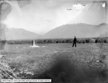
| 187 |
 |
Utah Lake Area - Utah Valley | 1910; 1906; 1907; 1908; 1909; 1911; 1912; 1913; 1914 | Image |
| 188 |
 |
Utah Valley | 1910; 1906; 1907; 1908; 1909; 1911; 1912; 1913; 1914 | Image |
| 189 |
 |
Utah Valley | 1910; 1906; 1907; 1908; 1909; 1911; 1912; 1913; 1914 | Image |
| 190 |
 |
Utah Valley - Farm | 1910; 1906; 1907; 1908; 1909; 1911; 1912; 1913; 1914 | Image |
| 191 |
 |
View of City and County Building | 1902 | Image |