|
|
Author | Title | Subject | Date | Publication Type |
| 1 |
 |
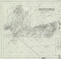
Parr, Clayton Joseph | A study of primary sedimentary structures around the Moab anticline, Grand County, Utah (Thesis and maps) | Geology; Utah; Grand County | 1965-08 | thesis |
| 2 |
 |
Parr, Clayton Joseph | A study of primary sedimentary structures around the Moab anticline, Grand County, Utah: Georeferenced map files | Geology; Utah; Grand County | 1965-08 | thesis |
| 3 |
 |
Brooke, John Percival | Alteration and trace elements of volcanics in the San Francisco Mountains | Mineralogy; Utah; Beaver County; Geochemistry; Ore deposits; Thesis and dissertation georeferencing project | 1964-06 | thesis |
| 4 |
|
Brooke, John Percival | Alteration and trace elements of volcanics in the San Francisco Mountains: Georeferenced map files | Thesis and dissertation georeferencing project | 1964-06 | thesis |
| 5 |
 |
Rodriguez, Enrique Levy | Economic geology of the sulphur deposits at Sulphurdale, Utah-Maps | | 1960-08 | thesis |
| 6 |
|
Rodriguez, Enrique Levy | Economic geology of the sulphur deposits at Sulphurdale, Utah: Georeferenced map files | Geology, Economic -- Utah -- Sulphurdale; Mines and mineral resources -- Utah -- Sulphurdale; Sulphur mines and mining -- Utah -- Sulphurdale | 1960-08 | thesis |
| 7 |
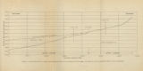 |
Gates, Joseph S. | Figure 4: Longitudinal profile of Middle Canyon showing locations of the profiles across the canyon, the nickpoint, and the hypothetical profile before rejuvenation | Thesis and dissertation georeferencing project | 1960-08 | thesis |
| 8 |
|
Blue, Donald McCoy | Geology and ore deposits of the Lucin Mining District, Box Elder County, Utah and Elko County, Nevada: Georeferenced map files | | 1960-08 | thesis |
| 9 |
 |
Blue, Donald McCoy | Geology and ore deposits of the lucin mining district, Box Elder County, Utah, and Elko County, Nevada-Maps | | 1960-08 | thesis |
| 10 |
 |
Chapusa, Frank W. P. | Geology and structure of Stansbury Island (Thesis and maps) | Geology; Utah; Stansbury Island | 1969-06 | thesis |
| 11 |
|
Chapusa, Frank W. P. | Geology and structure of Stansbury Island: Georeferenced map files | Geology; Utah; Stansbury Island | 1969-06 | thesis |
| 12 |
 |
Schaeffer, Frederick Ernst Jr. | Geology of the Central and Southern silver Island Mountains Tooele County, Utah and Elko County, Nevada-Maps | Geology -- Utah -- Silver Island Mountains | 1961-06 | thesis |
| 13 |
|
Schaeffer, Jr. Frederick Ernst | Geology of the Central and Southern Silver Island Mountains Tooele County, Utah and Elko County, Nevada: Georeferenced map files | | 1961-06 | thesis |
| 14 |
 |
Zimmerman, James T. | Geology of the Cove Creek area Millard County and Beaver County, Utah | Geology; Utah; Cove Creek area; Thesis and dissertation georeferencing project | 1961-06 | thesis |
| 15 |
 |
Harrill, James Reece | Geology of the Davis Knolls and northern Big Davis Mountain area, Tooele County, Utah | Geology -- Utah -- Tooele County; Thesis and dissertation georeferencing project | 1962-08 | thesis |
| 16 |
|
Harrill, James Reece | Geology of the Davis Knolls and northern Big Davis Mountain area, Tooele County, Utah: Georeferenced map files | Geology -- Utah -- Tooele County | 1962-08 | thesis |
| 17 |
 |
Doelling, Hellmut H. | Geology of the Northern Lakeside Mountains and the Grassy Mountains and vicinity, Tooele and Box Elder Counties, Utah | Geology -- Utah -- Tooele County; Geology -- Utah -- Box Elder County; Geology -- Utah -- Grassy Mountains -- Maps; Geology -- Utah -- Lakeside Mountains -- Maps | 1964-06 | thesis |
| 18 |
|
Doelling, Hellmut H. | Geology of the Northern Lakeside Mountains and the Grassy Mountains and vicinity, Tooele and Box Elder Counties, Utah: Georeferenced map files | Geology -- Utah -- Tooele County; Geology -- Utah -- Box Elder County; Geology -- Utah -- Grassy Mountains -- Maps; Geology -- Utah -- Lakeside Mountains -- Maps | 1964-06 | thesis |
| 19 |
 |
Moussa, Mounir Tawfik | Geology of the Soldier Summit quadrangle, Utah (Thesis and maps) | Geology; Utah; Utah County; Carbon County; Wasatch County | 1965-06 | thesis |
| 20 |
|
Moussa, Mounir Tawfik | Geology of the Soldier Summit quadrangle, Utah: Georeferenced map files | Geology; Utah; Utah County; Carbon County; Wasatch County | 1965-06 | thesis |
| 21 |
 |
Stifel, Peter Beekman | Geology of the Terrace and Hogup Mountains, Box Elder County, Utah | Geology -- Utah -- Box Elder County | 1964-06 | thesis |
| 22 |
|
Stifel, Peter Beekman | Geology of the Terrace and Hogup Mountains, Box Elder County, Utah: Georeferenced map files | Geology -- Utah -- Box Elder County | 1964-06 | thesis |
| 23 |
 |
Eriksson, Yves | Geology of the upper Ogden Canyon, Weber County, Utah | Geology -- Utah -- Weber County | 1960-06 | thesis |
| 24 |
|
Eriksson, Yves | Geology of the upper Ogden Canyon, Weber County, Utah: Georeferenced map files | Geology -- Utah -- Weber County | 1960-06 | thesis |
| 25 |
 |
Stouffer, Stephen Gerald | Landslides in the Coal Hill area, Kane County, Utah (Thesis and maps) | Landslides -- Utah -- Kane County; Geology -- Utah -- Kane County | 1964-06 | thesis |