Home
Browse
Ask Us
Chat
Harmful Language Statement
Log in
Theses & Dissertations
Advanced Search
Year
1905
1906
1907
1908
1909
1910
1911
1912
1913
1914
1915
1916
1917
1918
1919
1920
1921
1922
1923
1924
1925
1926
1927
1928
1929
1930
1931
1932
1933
1934
1935
1936
1937
1938
1939
1940
1941
1942
1943
1944
1945
1946
1947
1948
1949
1950
1951
1952
1953
1954
1955
1956
1957
1958
1959
1960
1961
1962
1963
1964
1965
1966
1967
1968
1969
1970
1971
1972
1973
1974
1975
1976
1977
1978
1979
1980
1981
1982
1983
1984
1985
1986
1987
1988
1989
1990
1991
1992
1993
1994
1995
1996
1997
1998
1999
2000
2001
2002
2003
2004
2005
2006
2007
2008
2009
2010
2011
2012
2013
2014
2015
2016
2017
2018
2019
TO
1905
1906
1907
1908
1909
1910
1911
1912
1913
1914
1915
1916
1917
1918
1919
1920
1921
1922
1923
1924
1925
1926
1927
1928
1929
1930
1931
1932
1933
1934
1935
1936
1937
1938
1939
1940
1941
1942
1943
1944
1945
1946
1947
1948
1949
1950
1951
1952
1953
1954
1955
1956
1957
1958
1959
1960
1961
1962
1963
1964
1965
1966
1967
1968
1969
1970
1971
1972
1973
1974
1975
1976
1977
1978
1979
1980
1981
1982
1983
1984
1985
1986
1987
1988
1989
1990
1991
1992
1993
1994
1995
1996
1997
1998
1999
2000
2001
2002
2003
2004
2005
2006
2007
2008
2009
2010
2011
2012
2013
2014
2015
2016
2017
2018
2019
School Or College
College of Mines & Earth Sciences
571
Department
Geology & Geophysics
338
Metallurgical Engineering
95
Atmospheric Sciences
75
Mining Engineering
41
Materials Science & Engineering
17
Metallurgy
2
Geological & Geophysical
1
Meteorology
1
Mineralogy
1
More
Publication Type
thesis
571
Subject
Utah
69
Geology
63
Thesis and dissertation georeferencing project
51
Stratigraphic
13
Thesis and dissertation georeferencing project
12
Atmospheric sciences
11
Materials science
11
Summit County
9
Cretaceous
7
Geology -- Utah -- Summit County
7
Geology -- Utah -- Tooele County
7
Geophysics
7
Coalville region
6
Geology -- Utah -- Beaver County
6
Geology -- Utah -- Box Elder County
6
Geology--Utah
6
Petrology
6
Stratigraphy
6
Wasatch County
6
Climate
5
Geology -- Utah -- Mineral Mountains
5
Grand County
5
Great Salt Lake
5
Zinc -- Metallurgy
5
Basalt -- Utah
4
Clouds
4
Electric prospecting
4
Electrodeposition
4
Engineering
4
Flotation
4
Geology -- Structural -- Utah -- Willard Peak area
4
Geology -- Utah -- Weber County
4
Green River Formation
4
Hydrometallurgy
4
Mining
4
Rocks
4
Sandstone
4
Sediments (Geology)
4
Uinta Basin
4
Beaver County
3
Box Elder County
3
Carbon County
3
Coal
3
Crystalline
3
Fluvial
3
GEMTIP
3
Geochemistry
3
Geology -- Uinta Mountains (Utah and Wyo.)
3
Geology -- Utah -- Juab County
3
Geology -- Utah -- Kane County -- Paria Northwest quadrangle
3
Geology -- Utah -- Sheeprock Mountains
3
Geology -- Utah -- Upton area
3
Geomorphology
3
Granite
3
Groundwater
3
Induced polarization
3
Inversion
3
Kenya
3
Lake Bonneville
3
Lidar
3
Metamorphic
3
Meteorology
3
Millard County
3
Mineral Range (Utah)
3
Moenkopi group
3
Mount Ogden
3
Natural gas
3
Newfoundland Mountains
3
Ore-dressing
3
Petrology -- Utah -- Beaver County
3
Petrology -- Utah -- Wasatch Mountains
3
Precambrian
3
Precipitation
3
Radar
3
Salt Lake County
3
Sedimentology
3
Sequence stratigraphy
3
Silver Island Mountains
3
Stansbury Island
3
Tertiary
3
Thaynes Formation
3
Utah County
3
Volcanic ash
3
Wasatch Hinterland
3
Geothermal resources -- Utah
2
Aerosol
2
Agglomeration
2
Alaska
2
Atmospheric Chemistry
2
Bonneville
2
Boundary layer
2
Bruneau-Jarbidge
2
Carbon dioxide
2
Climate change
2
Cloud physics
2
Coal mines and mining
2
Coal mines and mining, Utah
2
Cold-air pool
2
Copper
2
Copper -- Metallurgy
2
Diagenesis
2
Earthquakes
2
Electromagnetics
2
Electrometallurgy
2
Electrowinning
2
Flocculation
2
Frequency domain
2
Geology -- Utah -- Grassy Mountains -- Maps
2
Geology -- Utah -- Kane County
2
Geology -- Utah -- Lakeside Mountains -- Maps
2
Geology -- Utah -- Morgan County
2
Geothermal
2
Geothermal resources -- Utah
2
Gilsonite
2
Gravity
2
Great Salt Lake Basin
2
Heat flow
2
Hurricanes
2
Hydroclimate
2
Hydrologic sciences
2
Hydrology
2
Ichnology
2
John Henry Member
2
Juab County
2
Kaiparowits
2
Kaolinite
2
Landslides
2
Landslides -- Utah -- Kane County
2
Leaching
2
Lead -- Metallurgy
2
Lead ores
2
Mars
2
Mercury
2
Mesozoic
2
Metallurgy
2
Metamorphism
2
Methylation
2
Microphysics
2
Mine safety
2
Mines and mineral resources
2
Mines and mineral resources -- Utah -- Deep Creek Mountains
2
Mining engineering
2
Modeling
2
Mudstone
2
Nanoscience
2
Northern Utah
2
Numerical modeling
2
Oil-shales
2
Oxygen isotopes
2
PBM
2
Paleontology
2
Permeability
2
Petroleum
2
Polarization
2
Provenance
2
QEMSCAN
2
SNOTEL
2
Salt Lake Valley
2
Seismic
2
Shale
2
Short-circuit
2
Silver -- Metallurgy
2
Simulation
2
Southwestern Utah
2
Straight Cliffs
2
Stratigraphic geology
2
TRMM
2
Tropical cyclones
2
Tuff
2
Uinta Basin (Utah and Colo.)
2
Uinta Mountains
2
Ventilation
2
Wasatch Mountains
2
Wind
2
modeling
2
3-D focusing inversion
1
3D
1
A-Train
1
A-Train satellites
1
ARM
1
Acoustic waveform tomography
1
Activated carbon
1
Air pollution
1
Alloys
1
Alluvial Architecture
1
Alluvial architecture
1
Alta Stock
1
Aluminum
1
Aluminum, Metallurgy.
1
Ankylosauridae
1
Anvil region
1
Applied sciences
1
Aquifers - Analysis - Research
1
Arches
1
Arizona
1
Arsenic
1
Artic
1
Atlantic Ocean
1
Atmospheric
1
Atmospheric aerosols
1
Atmospheric boundary layer
1
Atmospheric mercury
1
Atmospheric waves
1
Axial compression
1
Axial fluvial system
1
Azores
1
Backbreak
1
Baenidae
1
Ball Milling
1
Ball mills, grinding media
1
Ballistic impact
1
Basin Analysis
1
Batholiths--Sierra Nevada
1
Bauxite ore
1
Beaver County, Cave Canyon detachment, Mineral Mountains, Sevier geothermal anomaly, southwestern Utah, Thermo Hot Springs
1
Behavior
1
Bessemer process
1
Bimodality
1
Bioprocess engineering
1
Bitumen
1
Bitumen, refining
1
Blast damage
1
Blast vibration
1
Blasting
1
Block
1
Bolide, Deep-sea, Paleoclimate, Qemscan, Sediment Velocity, XRF
1
Bonneville Lake Basin
1
Booster fan
1
Booster fans
1
Boulder batholith
1
Breakage rate
1
Bryce Canyon National Park
1
Bryce Canyon National Park (Utah)
1
Bryce Canyon National Park Erosion
1
Building stones -- Utah -- Salt Lake City
1
CALIPSO
1
CCS
1
CEMI
1
CFD
1
CFD-DEM simulation
1
Cambrian
1
Canyon
1
Canyons
1
Caprock
1
Carbon isotopes, Paleocene-Eocene thermal maximum
1
Carbon nanotubes
1
Carbon particle size
1
Carbonate
1
Carnallite
1
Catalyst
1
Cathode
1
Cauchy-type Integral
1
Cedar City
1
Cedar Mountains
1
Ceilometer
1
Centrosaurinae
1
Ceratopsidae
1
Change
1
Characterization
1
Chemical engineering
1
Chinle formation
1
Chlorides
1
Church Hills region
1
Circle cliffs
1
Circulation
1
Cirrus
1
Cirrus cloud
1
Cirrus clouds
1
Cirrus particle size
1
Clay -- Analysis
1
Clay mineralogy
1
Climate Change
1
Climate forecasting
1
Climatic changes
1
Climatology
1
Climatology;Earth temperature
1
Cloud Microphysics
1
Cloud microphysicas
1
CloudSat
1
Coal analysis
1
Coal ash
1
Coal mine
1
Coal mine waste
1
Coal mines and mining - Utah
1
Coated titanium anodes
1
Coke
1
Cold pool
1
Cold waves (Meteorology;)
1
Cole-cole
1
Collisional orogen
1
Colloid transport
1
Colloids
1
Colluvial wedges
1
Colorado
1
Colorado Plateau
1
Colorado plateau stratigraphy
1
Colt Mesa Mine
1
Column leaching
1
Comminution
1
Compensation
1
Complex resistivity
1
Compressive strength
1
Conductivity
1
Conjugate gradient method
1
Consolidation
1
Controlled sensitivity
1
Convection (Meteorology;)
1
Convective clouds
1
Convective systems
1
Copper - Metallurgy
1
Copper mines and mining
1
Copper, Metallurgy
1
Cordilleran Foreland Basin
1
Core-log calibration
1
Corrosion
1
Cove Creek area
1
Criterion
1
Crocodyliforms
1
Cross-country ski racing
1
Crystal structure
1
Crystallography
1
Cumulus
1
Cyanide process
1
Cyanides
1
Cyclic triaxial tests
1
Cyclones
1
Deep convection
1
Deep creek mountains
1
Dental Complexity
1
Depth to Basement
1
Desorption
1
Deterministic lateral displacement
1
Detrital zircon geochronology
1
Diamond-tungsten-metal composites
1
Diet
1
Dinosaur tracks
1
Direct reduction
1
Directional drilling
1
Discrete dipole approximation
1
Dislocation
1
Distributive Leadership
1
Dodecyl morpholine
1
Downslope
1
Dry and wet grinding
1
Dry deposition
1
Dual energy radiography
1
Duchesne County
1
Dust
1
Dynamic triggering
1
Dynamics
1
ENSO
1
EOFs
1
EPS
1
Early Eocene Climatic Optimum
1
Earth sciences
1
Earthquake detection
1
Earthquake effects
1
Earthquake hazard analysis
1
Earthquake nucleation
1
Economics
1
Eddy Currents
1
Eddy currents recycling of non ferrous scrap
1
Effect of coating thickness
1
Effect of metal substrat
1
Electrochemistry
1
Electrodynamic
1
Electrodynamic Sorting
1
Electrolytic Reduction
1
Electromagnetic
1
Electronics in surveying
1
Electroplating
1
Energy
1
Energy balance
1
Energy harvesting
1
Energy partitioning
1
Entradichnus
1
Entrainment
1
Entrainment interface layer
1
Environmental science
1
Eocene
1
Erosion -- Utah -- Bryce Canyon National Park
1
Estuary
1
Etch Pit
1
Ethics
1
Evanescent waves
1
Exit
1
Expanded polystyrene geofoam
1
Exploration
1
FEA Modeling
1
FEA modeling
1
FLAC
1
FLAC3D
1
FO-DTS
1
Fan installations
1
Farmington Bay
1
Fault intersections
1
Fault scarp morphology
1
Faults (Geology) -- Idaho -- Custer County Earthquakes -- Idaho -- Borah Peak
1
Faults (Geology) -- Nevada -- Lincoln County,Nye County
1
Favorable conditions
1
Feature tracking
1
Ferro-manganese
1
Field flow fractionation
1
Filtration
1
Filtration theory
1
Fine-scale precipitation
1
Fines content
1
Finite difference modeling
1
Fire weather
1
Flin Flon
1
Fluvial sandstone
1
Fog
1
Forecast verification
1
Fossils
1
Fracture intensity
1
Fragmentation
1
G.K. Gilbert
1
GEFS
1
GEM
1
GEMTIP model
1
GOM
1
GSL
1
Gamma ray spectrometry
1
General
1
General circulation modes
1
Geobiology
1
Geochemical prospecting, Utah
1
Geochemistry;Storglaciären
1
Geochronology
1
Geofoam
1
Geological
1
Geological mapping--Kenya
1
Geology - Kenya - Lake Turkana Region
1
Geology - Utah - Bingham Mining District
1
Geology - Utah - Carbon County
1
Geology - Utah - Silver Island Mountains
1
Geology - Utah - Utah County
1
Geology - Utah - Wasatch Range
1
Geology -- Kenya -- Baringo Basin
1
Geology -- Nevada
1
Geology -- Utah
1
Geology -- Utah -- Bryce Canyon National Park
1
Geology -- Utah -- Currant Creek Formation -- Stratigraphic -- Cretaceous -- Tertiary
1
Geology -- Utah -- Desert Mountain
1
Geology -- Utah -- Dry Canyon
1
Geology -- Utah -- Durst Mountain
1
Geology -- Utah -- Ely Formation
1
Geology -- Utah -- Garfield County
1
Geology -- Utah -- Huntsville Region
1
Geology -- Utah -- Juab County -- Tintic Mining District
1
Geology -- Utah -- Ogden Valley
1
Geology -- Utah -- Oquirrh Mountains
1
Geology -- Utah -- Silver Island Mountains
1
Geology -- Utah -- Soapstone Basin
1
Geology -- Utah -- Star Range
1
Geology -- Utah -- Tooele County -- Juab County -- Ore deposits -- Tintic Mining District
1
Geology of the Parowan Gap
1
Geology of the Red Hills
1
Geology, Economic -- Utah -- Sulphurdale
1
Geology, Pennsylvanian
1
Geology, Stratigraphic
1
Geology, Stratigraphic - Cretaceous
1
Geology, Stratigraphic - Pliocene
1
Geology, Stratigraphic -- Mesozoic
1
Geology, Stratigraphic -- Paleozoic
1
Geology, Structural
1
Geology, Uintah Basin (Utah and Colo.)
1
Geology--Colorado
1
Geology--Kenya--Koobi Fora Region
1
Geology: Stratigraphic-Paleozoic
1
Geomagnetism -- Secular variations
1
Geophysical
1
Geoscience
1
Geostationary satellite data
1
Geothermal brines
1
Geothermal resources -- Geology-- Utah -- Beaver County
1
Germanium
1
Germanium crystals, Testing
1
Gibbsitic bauxite ores
1
Glaciers
1
Glaciology
1
Global Positioning System
1
Global climate model
1
Gold
1
Gold -- Metallurgy
1
Gold cyanide
1
Gold cyanide adsorption
1
Gold mines and mining
1
Gold, metallurgy
1
Grand Staircase-Escalante National Monument
1
Great Basin
1
Great Salt Lake (Utah)
1
Green River Fomartion
1
Groundwater - Pollution - Research
1
Groundwater -- Utah
1
Groundwater -- Utah -- Grand County -- Quality
1
Groundwater -- Utah -- Ogden Valley
1
Groundwater tracers -- Utah -- Grand County
1
Gypsum
1
H/V ratio
1
HPGR
1
HRXMT
1
Habit
1
Heap leaching
1
Heber
1
Helium
1
Heterodont
1
High Temperature Physics
1
High-temperature high-pressure process
1
Hotspot
1
House Range
1
Hudson Bay Mining and Smelting Company Mines and mineral resources
1
Hull cell
1
Hurricane Joaquin
1
Hydraulic conductivity
1
Hydraulic fracturing
1
Hydrocarbon recovery
1
Hydrocarbons
1
Hydrochloric acid
1
Hydrogen
1
Hydrogenation
1
Hydrometeorology
1
Hydroxyapatite deposition
1
Hyperthermal Events
1
Hyperthermals
1
Hyporheic Flow
1
ICP-MS
1
Ice
1
Idaho
1
Igneous rocks - Utah
1
Impregnated diamond bits
1
Incised Valley
1
Inclined heterolithic strata
1
Induced
1
Infrasound
1
Inner cores
1
Inorganics
1
Integral transformation
1
Integrated sensitivity
1
Intensification
1
Intensity changes
1
Interferometry
1
Intrusions (Geology)
1
Intrusions (geology)
1
Ion microprobe
1
Iron
1
Iron Oxide
1
Iron, metallurgy
1
Iron-nickel alloys
1
Ironmaking
1
Isothermal Kinetics
1
Isotopic zoning
1
Jarosite
1
Jets
1
John henry member
1
Kaiparowits Plateau
1
Kaiparowits formation
1
Kaiparowits plateau
1
Kapusksasing Uplift
1
Kinetics
1
Kinetics study
1
Kosmoceratops
1
Kuparuk River Field
1
LIS
1
La-LDHs
1
Lacustrine
1
Lake
1
Lake Turkana
1
Lake effect
1
Lake evolution
1
Lake hydrology
1
Lake sediments, Utah, Great Salt Lake;Selenium, Utah, Great Salt Lake
1
Lake-effect
1
Lakeside mountains
1
Laminar Flow
1
Laminar flow
1
Landslide
1
Late triassic
1
Lattice-Boltzmann
1
Lead
1
Lead - Metallurgy
1
Lead, Metallurgy
1
Leakage
1
Least squares
1
Lightning
1
Liquid bridge
1
Liquid retention
1
Longwall mining
1
Loss
1
Lothidok Range
1
Low porosity
1
Low temperature engineering
1
Low-angle normal faulting
1
Lu-Hf
1
Lunar interior
1
MC3E
1
MCSEM
1
Mafic gneiss
1
Magnesium Hydride
1
Magnetic Separation
1
Magnetic gradiometry
1
Magnetic separation
1
Magnetostriction
1
Magnetotelluric
1
Malapsina Glacier
1
Mammatus
1
Mancos
1
Mancos shale
1
Manganese ore
1
Manganese ores
1
Manitoba
1
Marine Meteorology
1
Marine boundary layer
1
Marine boundary layer clouds
1
Marysvale
1
Marysvale, Utah--Mining
1
Mass
1
Mass balance
1
Materials Science
1
Maximum Feature Height
1
Maximum feature height
1
McArthur river mine
1
Mechanical engineering
1
Membrane filters
1
Membranes (Technology)
1
Mesoscale convective system
1
Mesozoic geologic boundaries
1
Metal separation
1
Metals
1
Metals--Microstructure
1
Meteor Crater (Ariz.)
1
Methyl Mercury
1
Mica
1
Microbiology
1
Microflotation
1
Microparticles
1
Microtremor
1
Microwave analog experiments
1
Midwest
1
Migration
1
Mill work
1
Mine drainage, Waste minimization
1
Mine hoisting
1
Mine management
1
Mine surveying
1
Mine ventilation
1
Mine water
1
Mineral Exploration
1
Mineral Mountains, Utah
1
Mineral exploration
1
Mineral industries-History
1
Mineral processing
1
Mineralogy--California--Analysis
1
Mineralogy--Indonesia--Analysis
1
Mineralogy--Utah
1
Mines
1
Mines and mineral resources -- Montana
1
Mines and mineral resources -- Utah -- Beaver County
1
Mines and mineral resources -- Utah -- Park City District Ore deposits -- Utah -- Park City district Brecote
1
Mines and mineral resources -- Utah -- Sulphurdale
1
Mines and mineral resources -- Utah -- Summit County
1
Mines and mineral resources-Beaver County
1
Mining Engineering
1
Mining Leadership
1
Mining-induced seismicity
1
Mirabilite
1
Mixed
1
Mixed waste stream
1
Model
1
Model evaluation
1
Modelling
1
Models
1
Moenkopi formation
1
Mogollon highlands, Straight Cliffs Formation
1
Moisture content
1
Molecular dynamics
1
Molten Salt
1
Monitoring
1
Monsoons
1
Monsoons--East Asia
1
Moonquakes
1
Morgan County
1
Mountain
1
Mountain climate
1
Mouth Bars
1
Mueller matrix elements
1
Multiscale waveform tomography
1
NAVGEM
1
NCEP
1
NRL
1
NWP
1
Nanoparticles
1
Nanotechnology
1
Nasutuceratops titusi
1
National Park
1
Neotectonics
1
Nephi segment
1
Nevada
1
Nickel alloys, Magnetic properties
1
Niobrara Formation
1
Noble Gas
1
Normal modes
1
Normalization of Deviance
1
North Atlantic atmosphere-ocean system
1
Norwood Tuff
1
Nuclear discriminant
1
Nuclear engineering
1
Nugget
1
Numerical Modeling
1
Numerical model
1
Numerical modelling
1
Numerical weather prediction
1
Nutrient cycling
1
OPCR
1
Occupational health
1
Ocean dynamics
1
Oil and gas drilling
1
Oil sands, Utah
1
Oil sands, refining
1
Oil shale
1
Oil-shales, United States
1
Omega equation
1
Ontario Mine (Park City, Utah)
1
Optimal
1
Ore deposits
1
Ore deposits - Utah - Utah County
1
Ore deposits -- Nevada
1
Ore deposits -- Utah
1
Ore upgrade
1
Ores - Sampling and estimation
1
Organized convection
1
Orographic
1
Oxygen Isotopes
1
Oxygen--Isotopes--Analysis
1
Ozone
1
PM10
1
Paleobiogeography
1
Paleoclimate indicators
1
Paleoecology
1
Paleoenvironments
1
Paleontology--Kenya--Koobi Fora Region
1
Paleoseismology
1
Paleosols
1
Particle separation
1
Pecos River Valley
1
Pedogenic carbonate
1
Peridynamics theory
1
Petroleum Geology
1
Petroleum prospecting
1
Petroleum--Saudi Arabia
1
Phase tensor
1
Phosphate industry
1
Phosphorus
1
Phylogeny
1
Physics
1
Pipe umbrella
1
Piute County
1
Plasma
1
Plasmonic metamaterials - Research
1
Pleistocene
1
Pollution
1
Polymer
1
Pore network structure
1
Pore water
1
Porosity
1
Potential Field Inversion
1
Potential field migration
1
Powder metallurgy
1
Precambrian
1
Precipitation climatology
1
Predictability
1
Predictive
1
Pressure Balancing
1
Prospecting
1
Psychological Empowerment
1
Pyroprocessing
1
Quantitative
1
Quartz
1
Quasi-geostrophic
1
Quaternary geology
1
Quintinite-3T
1
Rainbands
1
Rainfall properties
1
Rare earth elements
1
Ray Consolidated Copper Company
1
Ray tracing
1
Ray-based spatial resolution
1
Recycling of metals
1
Reduction (Chemistry)
1
Remote sensing
1
Reoxidation
1
Reservoir
1
Reservoir management
1
Resistance-in-series model
1
Resistivity
1
Resonance
1
Rhyolite
1
Rifts
1
Risk Tolerance
1
River channels
1
Rock Avalanche
1
Roof support
1
Rossby
1
SFG
1
SHPB
1
SPdKS
1
SSWs
1
Safeguards
1
Safety Leadership
1
Saint Elias Mountians
1
Saline
1
Salt Lake City
1
Salton Sea
1
Sandstone -- Utah Sandstone -- Wyoming Sandstone -- Idaho
1
Sandstone--Utah
1
Satellite meteorology
1
Saurian
1
ScP
1
Scanning Electron Microscopy
1
Scott M. Matheson Wetland Preserve (Utah)
1
Sea surface temperature
1
Sediment
1
Sedimentary Geology
1
Sedimentary basin
1
Sedimentary basins
1
Sedimentation and deformation
1
Sedimentation and deposition - Research
1
Sediments
1
Sediments (Geology) -- Utah -- Dakota Formation
1
Seepage blanket
1
Seepage meter
1
Seismic Imaging
1
Seismic model
1
Seismic prospecting
1
Seismic refraction
1
Seismicity
1
Seismology
1
Seismometers
1
Seismorgrams
1
Selective reduction
1
Selenium
1
Self assembly
1
Semiconductors,Testing
1
Sensible heat flux
1
Sensitivity
1
Sensitized
1
Sensors
1
Sequence
1
Severe convection
1
Sevier thrust belt
1
Shallow shear wave velocity
1
Shaped
1
Shared Leaderhsip
1
Shelby tube
1
Signal processing
1
Siliciclastic
1
Silo Field
1
Siltsone
1
Silver - Metallurgy
1
Simplified Porphry Model
1
Simulations
1
Size reduction of materials
1
Size-distributed media
1
Slope stability analysis
1
Smithsonite
1
Smooth inversion
1
Snow
1
Snow sensitivity
1
Snow--Tibet
1
Soil Temperature;Turkana
1
Soil liquefaction
1
Soil mechanics
1
Soil organic matter
1
Soil sciences
1
Soils -- Testing
1
South Lakeside Mountains
1
Southern Utah
1
Space-based
1
Spatial
1
Specific discharge
1
Split Stream
1
Sponcom
1
Spontaneous Combustion
1
St. George
1
Stable Isotope
1
Stansbury Mountains
1
Stansbury Range
1
State-based
1
Statistics
1
Storm tracks
1
Stormvex
1
Straight Cliffs Formation
1
Straight cliffs formation
1
Stratiform region
1
Stratigraphic-Mesozoic
1
Stratigraphy, ICSE
1
Stratocumulus
1
Stratosphere
1
Stratospheric Sudden Warmings
1
Stress-strain
1
Strontium isotopes
1
Structural
1
Structural Health Monitoring
1
Stucco
1
Subglacial geomorphology
1
Subglacial structure
1
Sudden
1
Sulphur mines and mining -- Utah -- Sulphurdale
1
Sunnyside Coal Mine, Sunnyside, Utah
1
Sunnyside oil-impregnated sandstone
1
Superior Province
1
Superior craton
1
Surface energy budget
1
Surface radiaton budget
1
Surface water
1
Suspension ironmaking
1
Systems science
1
TWP-ICE
1
Tailings Management
1
Tar sands
1
Tectonic geomorphology
1
Temperature variations
1
Tensile Strength
1
Thalassinoides
1
Thermal Battery
1
Thermal conductivity
1
Thermal properties
1
Thermally driven winds
1
Thermodynamics
1
Thesis and dissertation dereferencing project
1
Thin films
1
Thunderstorm
1
Thunderstorms
1
Ti thermometer
1
Tidal
1
Tight shale
1
Time domain
1
Time study
1
Time-domain analysis
1
Time-domain reflectometry
1
Titanium boride
1
Titanium nanotubes
1
Titanium-aluminum-vanadium alloysTesting;Nanostructured materials,Testing
1
Tomographic imaging
1
Tooele County
1
Topography
1
Tourmaline--Analysis
1
Trace
1
Trace Elements
1
Trace fossil
1
Tree rings
1
Tropical Convection
1
Tropical Rainfall Measuring Mission
1
Tropics
1
Tropics--Climate
1
Tropopause
1
Tungsten alloys
1
Turbulence
1
Typhoons
1
U-Pb geochronology
1
ULVZ
1
Uinta County
1
Uintah Basin
1
Unconventional
1
Underground
1
Upper Cambrian
1
Upper Cretaceous
1
Uranium
1
Uranium mines and mining
1
Uranium mining
1
Urban
1
Utah-Star Range
1
Utahceratops
1
Variable Frequency
1
Vein
1
Venting hypothesis
1
Vibration
1
Visualization
1
Volcanic ash, tuff, etc -- Kenya -- Baringo Basin
1
Volcanism -- Nevada -- Lincoln County, Nye County
1
Volume Integral Method
1
Wanship region
1
Wasatch
1
Wasatch Fault Zone
1
Wasatch Plateau - Utah
1
Wasatch Range (Utah and Idaho)
1
Wasatch fault
1
Washington fault
1
Water exchange
1
Water levels
1
Water pollution--Utah
1
Water resources management
1
Water treatment
1
Water, Purification, Biological treatment;Bioreactors
1
Wave-breaking
1
Weather forecasting
1
Weber Canyon
1
Western Interior Seaway
1
Western United States
1
Western interior basin
1
More
Filters:
Publication Type:
"thesis"
School Or College:
"College of Mines & Earth Sciences"
Collection:
ir_etd
401
-
425
of
571
<
12
13
14
15
16
17
18
19
20
21
>
Gallery view
Number of results to display per page
10
25
50
100
200
Sort by Relevance
Sort by Title A-Z
Sort by Title Z-A
Sort by Date Ascending
Sort by Date Descending
Sort by Last Modified Ascending
Sort by Last Modified Descending
Author
Title
Subject
Date
Publication Type
401
Sadeghi, Ali Reza
Plate 1: Geologic map of the Willard Peak area, North-Central Wasatch Mountains, Utah
1972-12
thesis
402
Sadeghi, Ali Reza
Plate 1: Geologic map of the Willard Peak area, North-Central Wasatch Mountains, Utah (Google Earth map overlay KMZ file)
Geology -- Structural -- Utah -- Willard Peak area; Thesis and dissertation georeferencing project
1972-12
thesis
403
Blue, Donald McCoy
Plate 1: Lucin mining district and vicinity, Northern Pilot Range, Box Elder County, Utah - Elko County, Nevada (Google Earth map overlay KMZ file)
Thesis and dissertation georeferencing project
1960-08
thesis
404
Schaeffer, Frederick Ernst Jr.
Plate 1B: Geologic map of the Central and Southern Silver Island Mountains, Box Elder and Tooele Counties, Utah, and Elko County, Nevada
1961-06
thesis
405
Schaeffer, Jr. Frederick Ernst
Plate 1B: Geologic map of the Central and Southern Silver Island Mountains, Box Elder and Tooele Counties, Utah, and Elko County, Nevada (Google Earth map overlay KMZ file)
Thesis and dissertation georeferencing project
1961-06
thesis
406
Schaeffer, Frederick Ernst Jr.
Plate 1C: Geologic cross sections of the Central and Southern Silver Island Mountains, Box Elder and Tooele Counties, Utah and Elko County, Nevada
1961-06
thesis
407
Johnson, Eric Henry
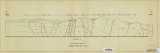
Plate 2 Topography, resistivity, and chargeability cross-sections along dipole-dipole line 1 on Fumarole Butte
Basalt -- Utah; Geothermal resources -- Utah
1975-08
thesis
408
Baker, Walker Holcombe
Plate 2: Cross-section A-A'
1959-06
thesis
409
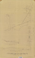
Rodriguez, Enrique Levy
Plate 2: Detailed geologic and vertical cross sections map of the Excelsior Orebody and New York Prospect Pit, Millard County, Utah
1960-08
thesis
410
Neff, Thomas Rodney
Plate 2: Sections along line A-A' and B-B'
1962-11
thesis
411
Blakey, Ronald Clyde
Plate 2: Structural sections
1970-08
thesis
412
Sadeghi, Ali Reza
Plate 2: Structure sections for geologic map of the Willard Peak area
1972-12
thesis
413
Hooper, Warren G.
Plate 3 Geologic map of portion of Northwestern Uinta Mountains, Utah (Google Earth map overlay KMZ file)
Geology -- Uinta Mountains (Utah and Wyo.); Thesis and dissertation georeferencing project
1951
thesis
414
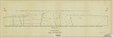
Johnson, Eric Henry
Plate 3 Topography, resistivity, and chargeability cross-sections along dipole-dipole line 2 on Fumarole Butte
Basalt -- Utah; Geothermal resources -- Utah
1975-08
thesis
415
Baker, Walker Holcombe
Plate 3: Cross-section B-B'
1959-06
thesis
416
Rodriguez, Enrique Levy
Plate 3: Detailed geologic and vertical cross section map of the Prince Albert Orebody, Mariposa and Queen Victoria Prospect Pits, Millard County, Utah
1960-08
thesis
417
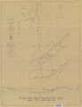
Mount, Donald Lee
Plate 3: Geologic map and sections of Wanship-Park City region, Utah
1952-06
thesis
418
Mount, Donald Lee
Plate 3: Geologic map and sections of Wanship-Park City region, Utah (Google Earth map overlay KMZ file)
Geology -- Utah -- Summit County
1952-06
thesis
419
Hooper, Warren G.
Plate 3: Geologic map of portion of Northwestern Uinta Mountains, Utah
1951
thesis
420
Sadeghi, Ali Reza
Plate 3: Palinspastic middle and upper Cambrian columnar sections from western and northern Utah
1972-12
thesis
421
Neff, Thomas Rodney
Plate 3: Structural map of the Little Willow Series, Wasatch Mountains, Utah
1962-11
thesis
422
Blakey, Ronald Clyde
Plate 3: Structural map of the Paria NW quadrangle, Kane County, Utah
1970-08
thesis
423
Blakey, Ronald Clyde
Plate 3: Structural sections
1970-08
thesis
424
Sadeghi, Ali Reza
Plate 4: Correlation of Precambrian rocks of the lower plate and upper plate of the Willard thrust with the Huntsville and Cottonwood areas
1972-12
thesis
425
Rodriguez, Enrique Levy
Plate 4: Detailed map showing diamond drill hole locations and vertical cross sections of the Sulphurdale Orebody, Beaver County, Utah
1960-08
thesis
401
-
425
of
571
<
12
13
14
15
16
17
18
19
20
21
>