Home
Browse
Ask Us
Chat
Harmful Language Statement
Log in
Advanced Search
Year
1839
1840
1841
1842
1843
1844
1845
1846
1847
1848
1849
1850
1851
1852
1853
1854
1855
1856
1857
1858
1859
1860
1861
1862
1863
1864
1865
1866
1867
1868
1869
1870
1871
1872
1873
1874
1875
1876
1877
1878
1879
1880
1881
1882
1883
1884
1885
1886
1887
1888
1889
1890
1891
1892
1893
1894
1895
1896
1897
1898
1899
1900
1901
1902
1903
1904
1905
1906
1907
1908
1909
1910
1911
1912
1913
1914
1915
1916
1917
1918
1919
1920
1921
1922
1923
1924
1925
1926
1927
1928
1929
1930
1931
1932
1933
1934
1935
1936
1937
1938
1939
1940
1941
1942
1943
1944
1945
1946
1947
1948
1949
1950
1951
1952
1953
1954
1955
1956
1957
1958
1959
1960
1961
1962
1963
1964
1965
1966
1967
1968
1969
1970
1971
1972
1973
1974
1975
1976
1977
1978
1979
1980
1981
1982
1983
1984
1985
1986
1987
1988
1989
1990
1991
1992
1993
1994
1995
1996
1997
1998
1999
2000
2001
2002
TO
1839
1840
1841
1842
1843
1844
1845
1846
1847
1848
1849
1850
1851
1852
1853
1854
1855
1856
1857
1858
1859
1860
1861
1862
1863
1864
1865
1866
1867
1868
1869
1870
1871
1872
1873
1874
1875
1876
1877
1878
1879
1880
1881
1882
1883
1884
1885
1886
1887
1888
1889
1890
1891
1892
1893
1894
1895
1896
1897
1898
1899
1900
1901
1902
1903
1904
1905
1906
1907
1908
1909
1910
1911
1912
1913
1914
1915
1916
1917
1918
1919
1920
1921
1922
1923
1924
1925
1926
1927
1928
1929
1930
1931
1932
1933
1934
1935
1936
1937
1938
1939
1940
1941
1942
1943
1944
1945
1946
1947
1948
1949
1950
1951
1952
1953
1954
1955
1956
1957
1958
1959
1960
1961
1962
1963
1964
1965
1966
1967
1968
1969
1970
1971
1972
1973
1974
1975
1976
1977
1978
1979
1980
1981
1982
1983
1984
1985
1986
1987
1988
1989
1990
1991
1992
1993
1994
1995
1996
1997
1998
1999
2000
2001
2002
Type
Image
1,283
Format
image/jpeg
1,026
application/pdf
251
Collection
Multimedia Archives Photographs - Res...
54
Photo Archives
974
Rare Books Collection
93
Ski and Snow Sports Archives
5
UAIDA Main Collection
7
University Archival Photographs (P0305)
2
Utah River Running Photo Archives
148
More
Filters:
Keywords:
"Native Americans"
Type:
"Image"
576
-
600
of
1,283
<
19
20
21
22
23
24
25
26
27
28
>
Gallery view
Number of results to display per page
10
25
50
100
200
Sort by Relevance
Sort by Title A-Z
Sort by Title Z-A
Sort by Date Ascending
Sort by Date Descending
Sort by Last Modified Ascending
Sort by Last Modified Descending
Title
Date
Type
Setname
576
Interior Navajo summer hogan, San Juan Valley
1915
Image
uum_map
577
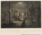
Interior of a Hut of a Mandan Chief
1841-03-01
Image
uum_rbc
578
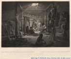
Interior of a Hut of a Mandan Chief
1841-03-01
Image
uum_rbc
579
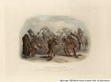
Ischoha-Kakoschochata, Dance of the Mandan Indians
1840-11-01
Image
uum_rbc
580
Ischoha-Kakoschochata, Dance of the Mandan Indians
1840-11-01
Image
uum_rbc
581
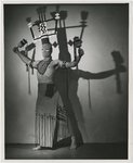
Jack Steen performing modern Indigenous dance [03]
1940; 1941; 1942; 1943; 1944; 1945; 1946; 1947; 1948; 1949; 1950; 1951; 1952; 1953; 1954; 1955; 1956; 1957; 1958; 1959
Image
uum_map
582
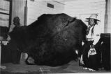
James Atwine and Andrew Frank (left) examining buffalo hides and reminiscing about the olden days. Mr. Atwine is 81 years of age and Mr. Frank 73. They are two of the every few elderly Utes living today.
1950
Image
uum_map
583
Jenny Rainbow (Monika Ramirez) in film "Joe Panther"
1975; 1976
Image
uum_map
584
Joe Panther (Ray Tracey) and Captain Ray Harper (Brian Keith) in film "Joe Panther"
1975; 1976
Image
uum_map
585
Joe Panther (Ray Tracey) and his friend, Billy Tiger (A Martinez) with dog Gator in film "Joe Panther"
1975; 1976
Image
uum_map
586
Joe Panther (Ray Tracey) and Jenny Rainbow (Monika Ramirez) in film "Joe Panther"
1975; 1976
Image
uum_map
587
Joe Panther (Ray Tracey) and Turtle George (Ricardo Montalban) in film "Joe Panther"
1975; 1976
Image
uum_map
588
Joe Panther (Ray Tracey) in film "Joe Panther"
1975; 1976
Image
uum_map
589
Joe Panther (Ray Tracey) talks with his uncle, Turtle George (Ricardo Montalban) in film "Joe Panther"
1975; 1976
Image
uum_map
590
Joe Panther (Ray Tracey) with wounded dog Gator in film "Joe Panther"
1975; 1976
Image
uum_map
591
Kaibab Indian School looking north. Alluvial flats at head of Two Mile Wash. Branch of Sevier fault passes between Navajo (left distance) and Chinle-Navajo (middle distance), Mohave County, AZ. 1939
1939
Image
uum_map
592
Kaibab Indian School near Moccasin looking northeast toward head of Two Mile Wash. Deep alluvial fill. Moenkopi capped by Shinarump (upper right), Chinle and Glen Canyon beds cliffs at upper left and middle distance (Lambs Point). Branch of Sevier fault crosses divide between Two Mile Wash and Sand Creek at base of Indian Point (left middle), Mohave County, AZ. 1939
1939
Image
uum_map
593
Kaibab Indian School, 1936.
1936
Image
uum_map
594
Kayenta parade celebrating completion of Route 1
1962-05-26
Image
uum_map
595
Kayenta, Indian wagons
1962-05-26
Image
uum_map
596
Kayenta, Indian woman on horse
1962-05-26
Image
uum_map
597
Keet Seel, cliff ruins east middle branch of Sagy (Towanaoche) canyon, Ariz., 1910 (Photo G165)
1910
Image
uum_map
598
Keet Seel, Segi Canyon, Navajo Reservation (J.D.L. VerPlank photo)
1910
Image
uum_map
599
Lake Canyon cliff dwelling
1962-05
Image
uum_map
600
Lake Canyon ruin
1962-05
Image
uum_map
576
-
600
of
1,283
<
19
20
21
22
23
24
25
26
27
28
>