Home
Browse
Ask Us
Chat
Harmful Language Statement
Log in
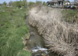
Advanced Search
Year
1880
1881
1882
1883
1884
1885
1886
1887
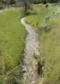
1888
1889
1890
1891
1892
1893
1894
1895
1896
1897
1898
1899
1900
1901
1902
1903
1904
1905
1906
1907
1908
1909
1910
1911
1912
1913
1914
1915
1916
1917
1918
1919
1920
1921
1922
1923
1924
1925
1926
1927
1928
1929
1930
1931
1932
1933
1934
1935
1936
1937
1938
1939
1940
1941
1942
1943
1944
1945
1946
1947
1948
1949
1950
1951
1952
1953
1954
1955
1956
1957
1958
1959
1960
1961
1962
1963
1964
1965
1966
1967
1968
1969
1970
1971
1972
1973
1974
1975
1976
1977
1978
1979
1980
1981
1982
1983
1984
1985
1986
1987
1988
1989
1990
1991
1992
1993
1994
1995
1996
1997
1998
1999
2000
2001
2002
2003
2004
2005
2006
2007
2008
2009
2010
2011
2012
2013
2014
2015
2016
2017
2018
2019
2020
2021
2022
TO
1880
1881
1882
1883
1884
1885
1886
1887
1888
1889
1890
1891
1892
1893
1894
1895
1896
1897
1898
1899
1900
1901
1902
1903
1904
1905
1906
1907
1908
1909
1910
1911
1912
1913
1914
1915
1916
1917
1918
1919
1920
1921
1922
1923
1924
1925
1926
1927
1928
1929
1930
1931
1932
1933
1934
1935
1936
1937
1938
1939
1940
1941
1942
1943
1944
1945
1946
1947
1948
1949
1950
1951
1952
1953
1954
1955
1956
1957
1958
1959
1960
1961
1962
1963
1964
1965
1966
1967
1968
1969
1970
1971
1972
1973
1974
1975
1976
1977
1978
1979
1980
1981
1982
1983
1984
1985
1986
1987
1988
1989
1990
1991
1992
1993
1994
1995
1996
1997
1998
1999
2000
2001
2002
2003
2004
2005
2006
2007
2008
2009
2010
2011
2012
2013
2014
2015
2016
2017
2018
2019
2020
2021
2022
Type
Image
69
Image/StillImage
37
Format
image/jpeg
107
Collection
Art and Art History
2
Civilian Conservation Corps
1
Classified Photographs
6
George M. Ottinger Photograph Collection
2
Hidden Water - Salt Lake County Water...
8
More Than A Flag: Utah State Flag Red...
2
Photo Archives
39
Regional History Center
12
Ski and Snow Sports Archives
1
Thorne Photographs
7
Uintah County Regional History Center...
12
Utah River Running Photo Archives
6
Vernal Express Photographs
8
Westminster College Photographs
1
More
Filters:
Format:
"image/jpeg"
1
-
25
of
107
<
1
2
3
4
5
>
Gallery view
Number of results to display per page
10
25
50
100
200
Sort by Relevance
Sort by Title A-Z
Sort by Title Z-A
Sort by Date Ascending
Sort by Date Descending
Sort by Last Modified Ascending
Sort by Last Modified Descending
Title
Date
Type
Setname
1
Dry Valley Camp, DG-157
1993-02
Image
dha_ccc
2
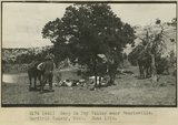
Camp in Dry Valley near Henrieville. Garfield County, UT. June 1918
1915
Image
uum_map
3
Looking Glass Rock, San Juan County, Utah ca.1916
1916
Image
uum_map
4
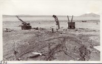
Hansel Valley Earthquake, 1934 - This well, previously dry for many years, flowed copiously immediately following earthquake
1934-03
Image/StillImage
uum_map
5
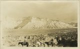
General view, wall of Dry Valley, 'Marine Jurassic', with Dakota top. Kane County, UT. 1924
1924
Image
uum_map
6
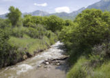
Creek at Dimple Dell
2010-06-09
Image
uu_hw_slcwd
7
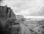
Church Rock in Dry Valley north of Monticello, UT, composed of La Plata sandstone. Near the base is red, shaly sandstone, middle La Plata, 42 feet thick, Lee, 1925
1925
Image
uum_map
8
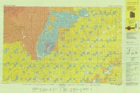
Westwater, Utah-Colorado 1981
1980; 1981
Image/StillImage
ucl_maps
9
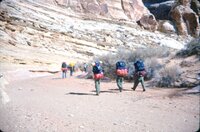
Dry Fork Canyon
1958
Image
ucl_tp
10
Dry Fork Canyon in Uintah County near Vernal, Utah
Image
ucl_tp
11
Dry Fork Canyon in Uintah County near Vernal, Utah
Image
ucl_tp
12
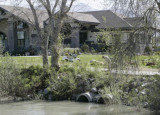
Dry Creek outlet at Jordan River
2009-05-06
Image
uu_hw_slcwd
13
Dry Fork
1958
Image
ucl_tp
14
Dry Fork Canyon
1958
Image
ucl_tp
15
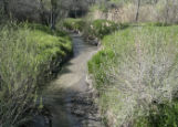
Creek and fairway
2009-05-06
Image
uu_hw_slcwd
16
Rivulet in Dimple Dell
2010-06-09
Image
uu_hw_slcwd
17
Creek near club house
2009-05-06
Image
uu_hw_slcwd
18
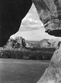
Dry Fork Window
1955; 1956; 1957; 1958; 1959; 1960
Image/StillImage
ucl_vep
19
Death Valley, 1981 [12]
1981
Image/StillImage
uum_map_rr
20
Dry Fork Flume
Image
ucl_tp
21
Goblin Valley, March 1975 [02]
1975-03
Image/StillImage
uum_map_usa
22
Alpine Station, Utah County [063]
1956-02
Image
uum_map
23
Alpine Station, Utah County [065]
1956-02
Image
uum_map
24
General view walls of Dry Valley, Kane County, UT 1924
Image
uum_map
25
Dry Farms-Cache Valley P.1
1940-08
Image
dha_cp
1
-
25
of
107
<
1
2
3
4
5
>