Home
Browse
Ask Us
Chat
Harmful Language Statement
Log in
Advanced Search
Year
1873
1874
1875
1876
1877
1878
1879
1880
1881
1882
1883
1884
1885
1886
1887
1888
1889
1890
1891
1892
1893
1894
1895
1896
1897
1898
1899
1900
1901
1902
1903
1904
1905
1906
1907
1908
1909
1910
1911
1912
1913
1914
1915
1916
1917
1918
1919
1920
1921
1922
1923
1924
1925
1926
1927
1928
1929
1930
1931
1932
1933
1934
1935
1936
1937
1938
1939
1940
1941
1942
1943
1944
1945
1946
1947
1948
1949
1950
1951
1952
1953
1954
1955
1956
1957
1958
1959
1960
1961
1962
1963
1964
1965
1966
1967
1968
1969
1970
1971
1972
1973
1974
1975
1976
1977
1978
1979
1980
1981
1982
1983
1984
1985
1986
1987
1988
1989
1990
1991
1992
1993
1994
1995
TO
1873
1874
1875
1876
1877
1878
1879
1880
1881
1882
1883
1884
1885
1886
1887
1888
1889
1890
1891
1892
1893
1894
1895
1896
1897
1898
1899
1900
1901
1902
1903
1904
1905
1906
1907
1908
1909
1910
1911
1912
1913
1914
1915
1916
1917
1918
1919
1920
1921
1922
1923
1924
1925
1926
1927
1928
1929
1930
1931
1932
1933
1934
1935
1936
1937
1938
1939
1940
1941
1942
1943
1944
1945
1946
1947
1948
1949
1950
1951
1952
1953
1954
1955
1956
1957
1958
1959
1960
1961
1962
1963
1964
1965
1966
1967
1968
1969
1970
1971
1972
1973
1974
1975
1976
1977
1978
1979
1980
1981
1982
1983
1984
1985
1986
1987
1988
1989
1990
1991
1992
1993
1994
1995
Type
Image/StillImage
62
Text
4
Image
3
Format
image/jpeg
69
Collection
Sanborn Fire Insurance Maps
3
UAIDA Main Collection
65
Uintah County Regional History Center...
1
Filters:
Format:
"image/jpeg"
1
-
25
of
69
<
1
2
3
>
Gallery view
Number of results to display per page
10
25
50
100
200
Sort by Relevance
Sort by Title A-Z
Sort by Title Z-A
Sort by Date Ascending
Sort by Date Descending
Sort by Last Modified Ascending
Sort by Last Modified Descending
Title
Date
Type
Setname
1
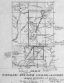
Map of Navajo, Ute, and Jicarilla Apache Indian Reserves
Image/StillImage
uaida_main
2
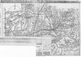
Map of Southern Colorado and the Ute Mountain Ute Reservation
Image/StillImage
uaida_main
3
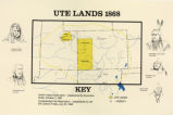
Ute Lands, 1868
Image/StillImage
uaida_main
4
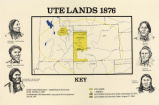
Map titled "Ute Lands, 1876"
Image/StillImage
uaida_main
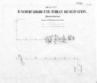
5
Map of Uncompahgre Ute reservation, Includes parcel divisions
Image/StillImage
uaida_main
6
Map of the Four Corners Region and the Reservation of the Ute Mountain Ute Tribe
Image/StillImage
uaida_main
7
Map titled, "Northern Ute Lands, 1905"
Image/StillImage
uaida_main
8
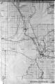
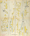
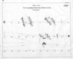
Bingham Canyon, 1913: Sheet 02
1913
Image
uum_sfim
9
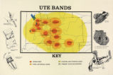
Map titled "Ute Bands Map"
Image/StillImage
uaida_main
10
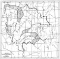
Map of Ute Reservation in Western Colorado, and Lands Ceded Over Time
1882
Image/StillImage
uaida_main
11
Map of Ute Territory by Band
Image/StillImage
uaida_main
12
Map of Ute Territory in Utah and Colorado by Band Name and Location
Image/StillImage
uaida_main
13
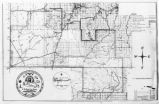
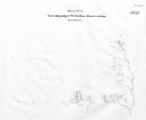
Map of Uncompahgre Ute Indian Reservation Boundaries, Sheet Number 5, 1889
Image/StillImage
uaida_main
14
Journal of Two Campaigns by the Utah Territorial Militia Against the Navajo Indians, 1869
1961
Text
uaida_main
15
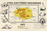
Map titled, "Utes and Their Neighbors"
Image/StillImage
uaida_main
16
Map showing boundaries of Northern Paiute, Southern Paiute, Shoshone Bannock and Ute
Image/StillImage
uaida_main
17
Map of a portion of the Uncompahgre Ute Indian Reservation
1908
Image/StillImage
uaida_main
18
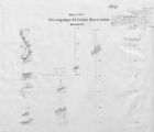
Map of Uncompahgre Ute Indian Reservation Boundaries, Sheet Number 6, 1889
Image/StillImage
uaida_main
19
Map of Uncompahgre Ute Indian Reservation Boundaries, Sheet Number 7, 1889
Image/StillImage
uaida_main
20
Map of a portion of the Uncompahgre Ute Indian Reservation, surveyed and subdivided for allotments to the Uncompahgre Ute Indians in accordance with the Act approved June 1880 by authority of Honorable N. C. McFarland, Commissioner General Land Office Daniel G. Major U.S. Surveyor 1882-1883
1882; 1883
Image/StillImage
uaida_main
21
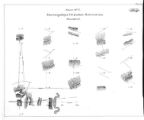
Map of Uncompahgre Ute Indian Reservation Boundaries, Sheet Number 1, 1889
Image/StillImage
uaida_main
22
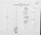
Map of Uncompahgre Ute Indian Reservation Boundaries, Sheet Number 2, 1889
Image/StillImage
uaida_main
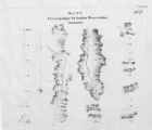
23
Map of Uncompahgre Ute Indian Reservation Boundaries, Sheet Number 3, 1889
Image/StillImage
uaida_main
24
Map of Uncompahgre Ute Indian Reservation Boundaries, Sheet Number 4, 1889
Image/StillImage
uaida_main
25
Map of Uncompahgre Ute Indian Reservation Boundaries, Sheet Number 8, 1889
Image/StillImage
uaida_main
1
-
25
of
69
<
1
2
3
>