| Title | Date | Type | Setname | ||
|---|---|---|---|---|---|
| 476 |  | "Frank Lloyd Wright studio, Fiesole, Italy [12]" | 1910 | Image/StillImage | uum_map |
| 477 |  | "Frank Lloyd Wright studio, Fiesole, Italy [13]" | 1910 | Image/StillImage | uum_map |
| 478 |  | "Frank Lloyd Wright studio, Fiesole, Italy [14]" | 1910 | Image/StillImage | uum_map |
| 479 |  | "Frank Lloyd Wright studio, Fiesole, Italy [15]" | 1910 | Image/StillImage | uum_map |
| 480 |  | "Frank Lloyd Wright studio, Fiesole, Italy [16]" | 1910 | Image/StillImage | uum_map |
| 481 |  | "Frank Lloyd Wright studio, Fiesole, Italy [17]" | 1910 | Image/StillImage | uum_map |
| 482 |  | "Frank Lloyd Wright studio, Fiesole, Italy [18]" | 1910 | Image/StillImage | uum_map |
| 483 |  | "Frank Lloyd Wright studio, Fiesole, Italy [19]" | 1910 | Image/StillImage | uum_map |
| 484 |  | "Frank Lloyd Wright studio, Fiesole, Italy [20]" | 1910 | Image/StillImage | uum_map |
| 485 |  | "Frank Lloyd Wright studio, Fiesole, Italy [21]" | 1910 | Image/StillImage | uum_map |
| 486 |  | "Frank Lloyd Wright studio, Fiesole, Italy [22]" | 1910 | Image/StillImage | uum_map |
| 487 |  | "Frank Lloyd Wright studio, Fiesole, Italy [23]" | 1910 | Image/StillImage | uum_map |
| 488 |  | "Free" sign | 1970; 1971; 1972; 1973; 1974; 1975; 1976; 1977; 1978; 1979; 1980; 1981; 1982; 1983; 1984; 1985; 1986; 1987 | Image | uum_hu |
| 489 |  | "Frey" (Organ Rock) formation capped by De Chelly conglomerate 3± miles from mouth of White Canyon. Chinle and Wingate at left, San Juan County, Utah, 1932. | 1932 | Image | uum_map |
| 490 |  | "Friday morning. The first sight of the Y ampa from the bridge near Lily Park, Colo[rado]" | 1957-05 | Image | uum_map_rr |
| 491 |  | "Friday night at John Hanks on the Yampa" | 1957-05 | Image | uum_map_rr |
| 492 |  | "Friends" | 1957; 1958; 1959; 1960; 1961; 1962 | uum_map_rr | |
| 493 | 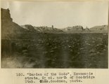 | "Garden of the Gods," Moencopie strata, 5± mi. north of Goodridge, Utah (Chas. Goodman photo) | 1909 | Image | uum_map |
| 494 | 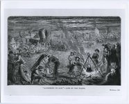 | "Gathering to Zion" | 1850; 1851; 1852; 1853; 1854; 1855; 1856; 1857; 1858; 1859; 1860; 1861; 1862; 1863; 1864; 1865; 1866; 1867; 1868; 1869; 1870; 1871; 1872; 1873; 1874; 1875; 1876; 1877; 1878; 1879; 1880; 1881; 1882; 1883; 1884; 1885; 1886; 1887; 1888; 1889; 1890; 1891; 1892; 1893; 1894; 1895; 1896; 1897; 1898; 1899; ... | Image/StillImage | uum_map |
| 495 |  | "General view of Mississippi River Power Plant. Government lock and dry dock, Keokuk, Iowa." | 1924; 1925; 1926; 1927; 1928 | Image/StillImage | uum_map |
| 496 | 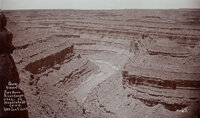 | "General view of San Juan River Canyon, Utah at Mendenhall's camp. 1000 feet deep." | 1890; 1891; 1892; 1893; 1894; 1895; 1896; 1897; 1898; 1899; 1900 | Image | uum_map_rr |
| 497 | 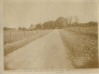 | "General view of the [Joseph Smith] Farm, road from Manchester to Palmyra." | 1924; 1925; 1926; 1927; 1928 | Image/StillImage | uum_map |
| 498 |  | "Gents" sign | 1970; 1971; 1972; 1973; 1974; 1975; 1976; 1977; 1978; 1979; 1980; 1981; 1982; 1983; 1984; 1985; 1986; 1987 | Image | uum_hu |
| 499 |  | "Gents" sign | 1970; 1971; 1972; 1973; 1974; 1975; 1976; 1977; 1978; 1979; 1980; 1981; 1982; 1983; 1984; 1985; 1986; 1987 | Image | uum_hu |
| 500 |  | "George and Yasuko Yasuda, wedding day, February 11, 1916, Japan." | 1916-02-11 | Image | uum_map |