Home
Browse
Ask Us
Chat
Harmful Language Statement
Log in
Photo Archives
Advanced Search
About
Over 70,000 photos covering a variety of topics from Marriott Library Special Collections
Year
1950
1951
1952
1953
1954
1955
1956
1957
1958
1959
1960
1961
1962
1963
1964
1965
1966
1967
1968
1969
1970
1971
1972
1973
1974
1975
TO
1950
1951
1952
1953
1954
1955
1956
1957
1958
1959
1960
1961
1962
1963
1964
1965
1966
1967
1968
1969
1970
1971
1972
1973
1974
1975
Type
Image
594
Format
image/jpeg
594
Collection
Photo Archives
594
Filters:
Format:
"image/jpeg"
276
-
300
of
594
<
7
8
9
10
11
12
13
14
15
16
>
Gallery view
Number of results to display per page
10
25
50
100
200
Sort by Relevance
Sort by Title A-Z
Sort by Title Z-A
Sort by Date Ascending
Sort by Date Descending
Sort by Last Modified Ascending
Sort by Last Modified Descending
Title
Date
Type
276
Mineral Bottom, Grand County, Utah [5]
1960-10-26
Image
277
Moab, Utah, from air
1964-03-05
Image
278
Nineteen percent grade coming from Hite concessionaire
1965-09-21
Image
279
Padre Creek, looking up from where it joins the Colorado
1963-03-14
Image
280
Park Avenue, Arches National Park [1]
1958-06-25
Image
281
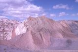
Purple rock "runner" along Cottonwood Wash road, southern Utah
1963-04-21
Image
282
Road through Capitol Reef and vegetation
1960-10
Image
283
Rock formation adjacent to Grosvenor Arch
1965-09-23
Image
284
Ruins along Warm Creek (will be flooded)
1963-03-13
Image
285
Sign about the Cockscomb formation, Cottonwood Canyon, Kane County, Utah
1973-05
Image
286
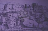
Sketch of a Native American Village
1966-07-25
Image
287
Southern Utah scenery
1963
Image
288
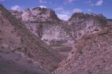
Steep mountains along Cottonwood Wash road, southern Utah
1963-04-21
Image
289
Upturned strata along Cottonwood Wash Road, southern Utah
1963-04-21
Image
290
Wild Sweet pea near camp, Glen Canyon
1963-04-23
Image
291
Along Interstate 70, Southern Utah [2]
1970-11-27
Image
292
Arches headquarters, visitor center, and switchback in loop road
1960-10-31
Image
293
Automobile on road to Grand View Point in Canyonlands National Park, Utah
1960-10-25
Image
294
Blackbrush in bloom, Hidden Passage Bar [1]
1963-04-25
Image
295
Bridge Canyon and Rainbow Bridge [2]
1960-06-12
Image
296
Bridge Canyon and Rainbow Bridge [3]
1960-06-12
Image
297
Bridge Canyon and Rainbow Bridge [4]
1960-06-12
Image
298
Castle Valley, Utah, La Sal Mountains beyond
1960-11-02
Image
299
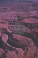
Colorado River canyonlands southwest of Moab [6]
1960-10-25
Image
300
Colorado River canyonlands southwest of Moab [7]
1960-10-25
Image
276
-
300
of
594
<
7
8
9
10
11
12
13
14
15
16
>