| Title | Date | Type | Setname | ||
|---|---|---|---|---|---|
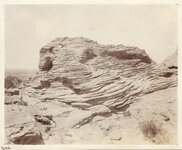
| 1 |
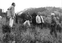 |
Alex Morley, Paul McCollister, and Willie Schaeffler on the far right, scoping out the mountain about half way up of what is now known as the "Slalom" ski run at Jackson Hole, circa 1961 | 1959; 1960; 1961; 1962; 1963 | Image/StillImage | uum_map_usa |
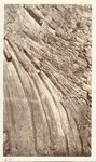
| 2 |
 |
Anticline - Five miles east of Cody, Wyo. | 1914-06 | Image/StillImage | uum_map |
| 3 |
 |
Anticline - Five miles east of Cody, Wyo. | 1914-06 | Image/StillImage | uum_map |
| 4 |
 |
Anticline - Five miles east of Cody, Wyo. | 1914-06 | Image/StillImage | uum_map |
| 5 |
 |
Anticline - Sheep Mountain - Wyo | 1914-06 | Image/StillImage | uum_map |
| 6 |
 |
Anticline - Sheep Mountain - Wyo | 1914-06 | Image/StillImage | uum_map |
| 7 |
 |
Anticline - Sheep Mountain - Wyo | 1914-06 | Image/StillImage | uum_map |
| 8 |
 |
Ashley National Forest - Forest Visitor Map 1998 | 1998 | Image/StillImage | ucl_maps |
| 9 |
 |
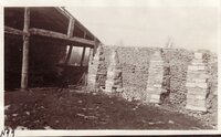
Black's Fork of the Green River p.1 | 1933; 1934; 1935; 1936; 1937; 1938; 1939; 1940; 1941; 1942; 1943; 1944; 1945; 1946 | Image/StillImage | dha_cp |
| 10 |
 |
Boundary of Shoshone Indian Territory according to Swanton, 1952 | 1952 | Image/StillImage | uaida_main |
| 11 |
 |
Boundary of Shoshone Indian Territory, Linguistic Boundaries of Shoshone and Bannock. | 1941 | Image/StillImage | uaida_main |
| 12 |
 |
Boundary of Shoshone Indian Territory, showing the locations of the Bannock | 1957 | Image/StillImage | uaida_main |
| 13 |
 |
Boundary of Shoshone Indian Territory, showing the locations of the Bannock from 1819 to 1951 | 1957 | Image/StillImage | uaida_main |
| 14 |
 |
Boundary of Shoshone Indian Territory, showing the locations where the Bannock and Shoshone reported together 1819-1956 | 1957 | Image/StillImage | uaida_main |
| 15 |
 |
Boundary of Shoshone Indian Territory; Doty Map of 1863 Indian Claims Commission | 1957 | Image/StillImage | uaida_main |
| 16 |
 |
Bridger, Wyoming, Cobble rock wall erected by Mormons | 1920; 1921; 1922; 1923; 1924; 1925; 1926; 1927; 1928; 1929; 1930; 1931; 1932; 1933; 1934; 1935 | Image/StillImage | uum_map |
| 17 |
 |
Cemetery, Lander, Wyoming | 1958; 1959; 1960; 1961; 1962 | Image/StillImage | uum_map |
| 18 |
 |
Charley and Norma Burton at Snowy Cabin | 1947; 1948; 1949; 1950 | Image/StillImage | ucl_rhc |
| 19 |
 |
Chief Washakie | 1888; 1889; 1890; 1891; 1892 | Image/StillImage | uaida_main |
| 20 |
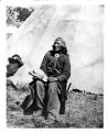 |
Chief Washakie seated in front of a tepee | 1885 | Image/StillImage | uaida_main |
| 21 |
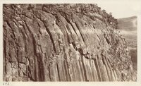 |
Columnar Structure - Little Snake River - SW Wyoming | 1907; 1908; 1909; 1910; 1911; 1912; 1913; 1914; 1915; 1916; 1917; 1918; 1919; 1920; 1921; 1922; 1923; 1924; 1925; 1926; 1927; 1928; 1929; 1930; 1931; 1932; 1933; 1934; 1935 | Image/StillImage | uum_map |
| 22 |
 |
Columnar Structure - Little Snake River - SW Wyoming | 1907; 1908; 1909; 1910; 1911; 1912; 1913; 1914; 1915; 1916; 1917; 1918; 1919; 1920; 1921; 1922; 1923; 1924; 1925; 1926; 1927; 1928; 1929; 1930; 1931; 1932; 1933; 1934; 1935 | Image/StillImage | uum_map |
| 23 |
 |
Columnar Structure - Little Snake River - SW Wyoming | 1907; 1908; 1909; 1910; 1911; 1912; 1913; 1914; 1915; 1916; 1917; 1918; 1919; 1920; 1921; 1922; 1923; 1924; 1925; 1926; 1927; 1928; 1929; 1930; 1931; 1932; 1933; 1934; 1935 | Image/StillImage | uum_map |
| 24 |
 |
Cross bedding, one mile south of Cowley, Wyo. | 1907; 1908; 1909; 1910; 1911; 1912; 1913; 1914; 1915; 1916; 1917; 1918; 1919; 1920; 1921; 1922; 1923; 1924; 1925; 1926; 1927; 1928; 1929; 1930; 1931; 1932; 1933; 1934; 1935 | Image/StillImage | uum_map |
| 25 |
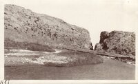 |
Devils Gate, Sweetwater River, Wyoming | 1920; 1921; 1922; 1923; 1924; 1925; 1926; 1927; 1928; 1929; 1930; 1931; 1932; 1933; 1934; 1935 | Image/StillImage | uum_map |