Home
Browse
Ask Us
Chat
Harmful Language Statement
Log in
Advanced Search
Year
1873
1874
1875
1876
1877
1878
1879
1880
1881
1882
1883
1884
1885
1886
1887
1888
1889
1890
1891
1892
1893
1894
1895
1896
1897
1898
1899
1900
1901
1902
1903
1904
1905
1906
1907
1908
1909
1910
1911
1912
1913
1914
1915
1916
1917
1918
1919
1920
1921
1922
1923
1924
1925
1926
1927
1928
1929
1930
1931
1932
1933
1934
1935
1936
1937
1938
1939
1940
1941
1942
1943
1944
1945
1946
1947
1948
1949
1950
1951
1952
1953
1954
1955
1956
1957
1958
1959
1960
1961
1962
1963
1964
1965
1966
1967
1968
1969
1970
1971
1972
1973
1974
1975
1976
1977
1978
1979
1980
1981
1982
1983
1984
1985
1986
1987
1988
1989
1990
1991
1992
1993
1994
1995
1996
1997
1998
1999
2000
2001
2002
TO
1873
1874
1875
1876
1877
1878
1879
1880
1881
1882
1883
1884
1885
1886
1887
1888
1889
1890
1891
1892
1893
1894
1895
1896
1897
1898
1899
1900
1901
1902
1903
1904
1905
1906
1907
1908
1909
1910
1911
1912
1913
1914
1915
1916
1917
1918
1919
1920
1921
1922
1923
1924
1925
1926
1927
1928
1929
1930
1931
1932
1933
1934
1935
1936
1937
1938
1939
1940
1941
1942
1943
1944
1945
1946
1947
1948
1949
1950
1951
1952
1953
1954
1955
1956
1957
1958
1959
1960
1961
1962
1963
1964
1965
1966
1967
1968
1969
1970
1971
1972
1973
1974
1975
1976
1977
1978
1979
1980
1981
1982
1983
1984
1985
1986
1987
1988
1989
1990
1991
1992
1993
1994
1995
1996
1997
1998
1999
2000
2001
2002
Type
Image/StillImage
62
Image
36
Text
5
Format
image/jpeg
102
Collection
Beckwith Photograph Collection
8
Classified Photographs
10
Clifton Bray Film Negatives
10
Extractions from the Land: Mining and...
2
Olympic Legacy
5
Peoples of Utah Revisited
1
Photo Archives
5
Salt Lake Tribune Negative Collection
14
Shipler Collection Negative Preservat...
18
Shipler Commercial Photographers
6
Ski and Snow Sports Archives
1
UAIDA Main Collection
20
Vernal Express Photographs
2
More
Filters:
Format:
"image/jpeg"
Subject:
"Maps"
Year End:
2006
1
-
25
of
102
<
1
2
3
4
5
>
Gallery view
Number of results to display per page
10
25
50
100
200
Sort by Relevance
Sort by Title A-Z
Sort by Title Z-A
Sort by Date Ascending
Sort by Date Descending
Sort by Last Modified Ascending
Sort by Last Modified Descending
Title
Date
Type
Setname
1
1833 Hyrum Reclamation Project Map
1933-01
Image; Text
dha_pour
2
Air View Map
1951-11-07
Image
dha_scp
3
Air View Map
1951-11-07
Image
dha_scp
4
Airways Map Coach Lines
1943-06-22
Image/StillImage
dha_sltnc
5
Alameda, Idaho Map of city
1947-05-22
Image/StillImage
dha_sltnc
6
Anderson, Major Gen. LeRoy H.; Ostler, Brig. Gen. H. L. -Shot 2
1955-02-19
Image/StillImage
dha_sltnc
7
Anderson, Major Gen. LeRoy H.; Ostler, Brig. Gen. H. L. -Shot 3
1955-02-19
Image/StillImage
dha_sltnc
8
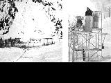
Avalanche tower and map
1940; 1941; 1942; 1943; 1944; 1945; 1946; 1947; 1948; 1949; 1950; 1951; 1952; 1953; 1954; 1955; 1956; 1957; 1958; 1959; 1960; 1961; 1962; 1963; 1964; 1965; 1966; 1967; 1968; 1969
Image
uum_map_usa
9
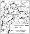
Boundary of Shoshone Indian Territory
1957
Image/StillImage
uaida_main
10
Boundary of Shoshone Indian Territory according to Swanton, 1952
1952
Image/StillImage
uaida_main
11
Boundary of Shoshone Indian Territory and Neighboring Tribes
1957
Image/StillImage
uaida_main
12
Boundary of Shoshone Indian Territory, Linguistic Boundaries of Shoshone and Bannock.
1941
Image/StillImage
uaida_main
13
Boundary of Shoshone Indian Territory, showing the locations of the Bannock
1957
Image/StillImage
uaida_main
14
Boundary of Shoshone Indian Territory, showing the locations of the Bannock from 1819 to 1951
1957
Image/StillImage
uaida_main
15
Boundary of Shoshone Indian Territory, showing the locations where the Bannock and Shoshone reported together 1819-1956
1957
Image/StillImage
uaida_main
16
Boundary of Shoshone Indian Territory; Doty Map of 1863 Indian Claims Commission
1957
Image/StillImage
uaida_main
17
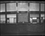
C. P. Overfield, Front of Ticket Office at Denver and Rio Grande Railroad Company Station
1929-03-19
Image/StillImage
dha_scnpp
18
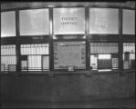
C. P. Overfield, Front of Ticket Office at Denver and Rio Grande Railroad Company Station
1929-03-19
Image/StillImage
dha_scnpp
19
Capitol Building-Exhibits P.1
1920; 1921; 1922; 1923; 1924; 1925; 1926; 1927; 1928; 1929; 1930; 1931; 1932; 1933; 1934; 1935; 1936; 1937; 1938; 1939; 1940; 1941; 1942; 1943; 1944; 1945; 1946; 1947; 1948; 1949; 1950
Image/StillImage
dha_cp
20
Colorado River -- Excursions p.14
1935; 1936; 1937; 1938; 1939; 1940; 1941; 1942; 1943; 1944; 1945
Image/StillImage
dha_cp
21
Dept. of Int. Indian Irrigation Service, Copy of Blue Print, Blackfoot River & Gray Lake Dev.
1921-06-18
Image/StillImage
dha_scnpp
22
Dinosaur National Monument
1958-05-29
Image
ucl_vep
23
Dr.S.H. Goodwin
1926-08-09
Image/StillImage
dha_scnpp
24
El Palacio, volume 30, nos.19-20 (May 20, 1931) [02]: Map, Nine Mile Canyon
1931-05-20
Image
dc_bpc
25
Escalante Valley Improvement Company Map
1915-11-19
Image
dha_scp
1
-
25
of
102
<
1
2
3
4
5
>