|
|
Title | Date | Type | Setname |
| 1 |
 |
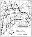
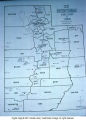
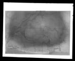
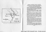
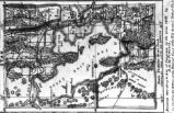
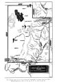
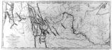
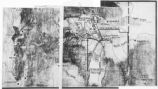
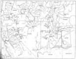
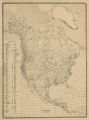
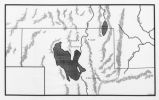
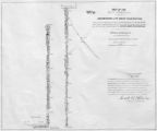
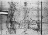
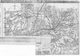
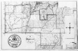
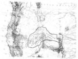
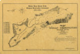
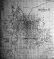
1833 Hyrum Reclamation Project Map | 1933-01 | Image; Text | dha_pour |
| 2 |
 |
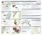
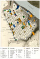
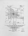
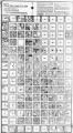
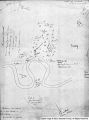
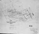
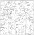
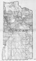
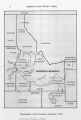
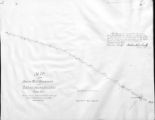
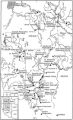
2010 Boundary Validation Program_001 | | Image/StillImage | uaida_main |
| 3 |
 |
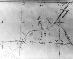
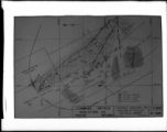
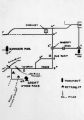
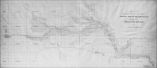
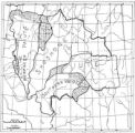
2010 Boundary Validation Program_002 | | Image/StillImage | uaida_main |
| 4 |
 |
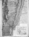
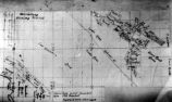
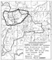
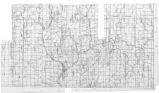
2010 Boundary Validation Program_003 | | Image/StillImage | uaida_main |
| 5 |
 |
2010 Boundary Validation Program_004 | | Image/StillImage | uaida_main |
| 6 |
 |
2010 Boundary Validation Program_005 | | Image/StillImage | uaida_main |
| 7 |
 |
2010 Boundary Validation Program_006 | | Image/StillImage | uaida_main |
| 8 |
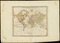 |
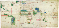
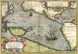
A chart of the world upon Mercator's projection : describing the tracks of Capt. Cook in the year 1768, 69, 70, 71, and in 1772, 73, 74, 75, with the new discoveries | | Image | uu_aah_art |
| 9 |
 |
A new plan of ye great town of Boston in New England in America, with the many additionall [sic] buildings, & new streets, to the year, 1769 | | Image | uu_aah_art |
| 10 |
 |
A Plan of the Town of New Haven with all the Buildings in 1748 | | Image | uu_aah_art |
| 11 |
 |
Air View Map | 1951-11-07 | Image | dha_scp |
| 12 |
 |
Air View Map | 1951-11-07 | Image | dha_scp |
| 13 |
 |
Airways Map Coach Lines | 1943-06-22 | Image/StillImage | dha_sltnc |
| 14 |
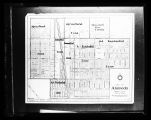 |
Alameda, Idaho Map of city | 1947-05-22 | Image/StillImage | dha_sltnc |
| 15 |
 |
Americae sive Novi Orbis, Noca Descripto (A New Description of America or the New World) | | Image | uu_aah_art |
| 16 |
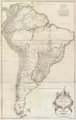 |
Amerique Meridionale Publiee sous les Auspices de Monseigneur le Duc d'Orleans | | Image | uu_aah_art |
| 17 |
 |
Anderson, Major Gen. LeRoy H.; Ostler, Brig. Gen. H. L. -Shot 2 | 1955-02-19 | Image/StillImage | dha_sltnc |
| 18 |
 |
Anderson, Major Gen. LeRoy H.; Ostler, Brig. Gen. H. L. -Shot 3 | 1955-02-19 | Image/StillImage | dha_sltnc |
| 19 |
 |
Athens, Greece, plan | | Image | uu_aah_art |
| 20 |
 |
Atlas of Maritime Charts (The Catalan Atlas) | | Image | uu_aah_art |
| 21 |
 |
Atlas of Maritime Charts (The Catalan Atlas), detail showing Mansa Musa | | Image | uu_aah_art |
| 22 |
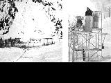 |
Avalanche tower and map | 1940; 1941; 1942; 1943; 1944; 1945; 1946; 1947; 1948; 1949; 1950; 1951; 1952; 1953; 1954; 1955; 1956; 1957; 1958; 1959; 1960; 1961; 1962; 1963; 1964; 1965; 1966; 1967; 1968; 1969 | Image | uum_map_usa |
| 23 |
 |
Battle of Bear River--Map P.1 | | Image | dha_cp |
| 24 |
 |
Birdseye View of Salt Lake City P.1 | | Image | dha_cp |
| 25 |
 |
Boston, its environs and harbour, with the rebels works raised against that town in 1775 | | Image | uu_aah_art |
| 26 |
 |
Boundary of Shoshone Indian Territory | 1957 | Image/StillImage | uaida_main |
| 27 |
 |
Boundary of Shoshone Indian Territory according to Swanton, 1952 | 1952 | Image/StillImage | uaida_main |
| 28 |
 |
Boundary of Shoshone Indian Territory and Neighboring Tribes | 1957 | Image/StillImage | uaida_main |
| 29 |
 |
Boundary of Shoshone Indian Territory, Linguistic Boundaries of Shoshone and Bannock. | 1941 | Image/StillImage | uaida_main |
| 30 |
 |
Boundary of Shoshone Indian Territory, showing the locations of the Bannock | 1957 | Image/StillImage | uaida_main |
| 31 |
 |
Boundary of Shoshone Indian Territory, showing the locations of the Bannock from 1819 to 1951 | 1957 | Image/StillImage | uaida_main |
| 32 |
 |
Boundary of Shoshone Indian Territory, showing the locations where the Bannock and Shoshone reported together 1819-1956 | 1957 | Image/StillImage | uaida_main |
| 33 |
 |
Boundary of Shoshone Indian Territory; Doty Map of 1863 Indian Claims Commission | 1957 | Image/StillImage | uaida_main |
| 34 |
 |
British North America P.1 | | Image | dha_cp |
| 35 |
 |
Bureau of Indian Affairs | | Image/StillImage | uaida_main |
| 36 |
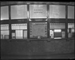 |
C. P. Overfield, Front of Ticket Office at Denver and Rio Grande Railroad Company Station | 1929-03-19 | Image/StillImage | dha_scnpp |
| 37 |
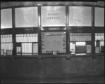 |
C. P. Overfield, Front of Ticket Office at Denver and Rio Grande Railroad Company Station | 1929-03-19 | Image/StillImage | dha_scnpp |
| 38 |
 |
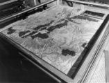
Cache Valley Relief Map P.1 | | Image | dha_cp |
| 39 |
 |
Camp Floyd Mining District P.1 | | Image | dha_cp |
| 40 |
 |
Cantino Planisphere | | Image | uu_aah_art |
| 41 |
 |
Capitol Building-Exhibits P.1 | 1920; 1921; 1922; 1923; 1924; 1925; 1926; 1927; 1928; 1929; 1930; 1931; 1932; 1933; 1934; 1935; 1936; 1937; 1938; 1939; 1940; 1941; 1942; 1943; 1944; 1945; 1946; 1947; 1948; 1949; 1950 | Image/StillImage | dha_cp |
| 42 |
 |
Carbon County, Utah P.1 | | Image | dha_cp |
| 43 |
 |
Churches, Schools NE | | Image | wc_pc |
| 44 |
 |
Churches, Schools, Missions in Utah. | | Image | wc_pc |
| 45 |
 |
City of Zion--Map P.1 | | Image | dha_cp |
| 46 |
 |
Civic Center, Salt Lake City P.1 | | Image | dha_cp |
| 47 |
 |
Clarkston, Utah P.1 | | Image | dha_cp |
| 48 |
 |
Colorado Plateau--Map P.1 | | Image | dha_cp |
| 49 |
 |
Colorado River (Bishop Map) P.1 | | Image | dha_cp |
| 50 |
 |
Colorado River (Upper Basin) P.1 | | Image | dha_cp |
| 51 |
 |
Colorado River -- Excursions p.14 | 1935; 1936; 1937; 1938; 1939; 1940; 1941; 1942; 1943; 1944; 1945 | Image/StillImage | dha_cp |
| 52 |
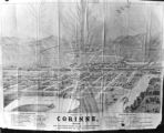 |
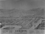
Corinne, Utah P.1 | | Image | dha_cp |
| 53 |
 |
Cottonwood Mining District P.1 | | Image | dha_cp |
| 54 |
 |
Dept. of Int. Indian Irrigation Service, Copy of Blue Print, Blackfoot River & Gray Lake Dev. | 1921-06-18 | Image/StillImage | dha_scnpp |
| 55 |
 |
Dinosaur National Monument | 1958-05-29 | Image | ucl_vep |
| 56 |
 |
Dr.S.H. Goodwin | 1926-08-09 | Image/StillImage | dha_scnpp |
| 57 |
 |
Dry Canyon Ophir Mining District P.1 | | Image | dha_cp |
| 58 |
 |
Dura Europos, general site plan | | Image | uu_aah_art |
| 59 |
 |
Echo Canyon P.1 | | Image | dha_cp |
| 60 |
 |
Echo Canyon P.2 | | Image | dha_cp |
| 61 |
 |
Echo Canyon P.3 | | Image | dha_cp |
| 62 |
 |
El Palacio, volume 30, nos.19-20 (May 20, 1931) [02]: Map, Nine Mile Canyon | 1931-05-20 | Image | dc_bpc |
| 63 |
 |
Emigrant Road from Independence to San Fran. P.1 | | Image | dha_cp |
| 64 |
 |
Escalante Map P.1 | | Image | dha_cp |
| 65 |
 |
Escalante Route Map P.1 | | Image | dha_cp |
| 66 |
 |
Escalante Valley Improvement Company Map | 1915-11-19 | Image | dha_scp |
| 67 |
 |
Escalante, Utah--Map P.1 | | Image | dha_cp |
| 68 |
 |
F.B. Cook | 1936-05-20 | Image/StillImage | dha_scnpp |
| 69 |
 |
F.J. Salathe Jr., Copy of Section of Map | 1928-09-01 | Image/StillImage | dha_scnpp |
| 70 |
 |
Father Escalante's Map | 1941 | Text | uaida_main |
| 71 |
 |
Ford Motor CO. | 1925-08-13 | Image/StillImage | dha_scnpp |
| 72 |
 |
Ford Motor CO. | 1925-08-13 | Image/StillImage | dha_scnpp |
| 73 |
 |
Fort Bridger P.1 | | Image | dha_cp |
| 74 |
 |
Fort Douglas Utah Territory P.1 | | Image | dha_cp |
| 75 |
 |
Fur Traders' Route (Peter Skene Ogden) P.1 | | Image | dha_cp |
| 76 |
 |
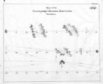
Goshute Indian Reservation Nevada and Utah | | Image/StillImage | uaida_main |
| 77 |
 |
Great Salt Lake P.1 | | Image | dha_cp |
| 78 |
 |
Great Salt Lake P.2 | | Image | dha_cp |
| 79 |
 |
Great Salt Lake City P.1 | | Image | dha_cp |
| 80 |
 |
Great Salt Lake--Ferris P.1 | | Image | dha_cp |
| 81 |
 |
Great Salt Lake--Trails of Charles Stoddard P.1 | | Image | dha_cp |
| 82 |
 |
The Green & Colorado Rivers P.1 | | Image | dha_cp |
| 83 |
 |
Gunnison Massacre [19] : Map accompanying a transcript of part of Josiah Gibbs' account, from "Lights and Shadows of Mormonism" (1909), pp. 176-189 | 1926 | Image | dc_bpc |
| 84 |
 |
Gunnison Massacre--Site P.1 | | Image | dha_cp |
| 85 |
 |
Harrisburg Mining District P.1 | | Image | dha_cp |
| 86 |
 |
Hastings Cutoff--Map P.1 | | Image | dha_cp |
| 87 |
 |
Host City map of downtown | 2002 | Image | dha_olyleg |
| 88 |
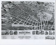 |
Illustrated map of Helena, Montana | 1890 | Image/StillImage | uum_map |
| 89 |
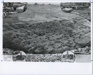 |
Illustrated map of Phoenix, Arizona | 1886; 1887; 1888; 1889; 1890; 1891; 1892; 1893; 1894; 1895; 1896; 1897; 1898; 1899; 1900; 1901; 1902; 1903; 1904; 1905; 1906; 1907; 1908; 1909; 1910 | Image/StillImage | uum_map |
| 90 |
 |
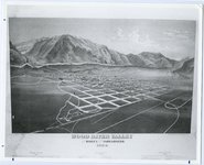
Illustrated map of Prescott, Arizona Territory | 1886; 1887; 1888; 1889; 1890; 1891; 1892; 1893; 1894; 1895; 1896; 1897; 1898; 1899; 1900; 1901; 1902; 1903; 1904; 1905; 1906; 1907; 1908; 1909; 1910 | Image/StillImage | uum_map |
| 91 |
 |
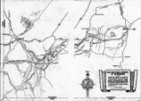
Illustrated map of Wood River Valley, Idaho | 1884 | Image/StillImage | uum_map |
| 92 |
 |
Int. Smelting Company | 1932-03-26 | Image/StillImage | dha_scnpp |
| 93 |
 |
Int. Smelting Company | 1932-03-26 | Image/StillImage | dha_scnpp |
| 94 |
 |
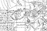
J.E. Himes, Copy of Fifth Page of Letter (Map) | 1929-07-11 | Image/StillImage | dha_scnpp |
| 95 |
 |
Jas. Invers, Copy of Blue Print | 1922-02-28 | Image/StillImage | dha_scnpp |
| 96 |
 |
Jeremy Ranch--Map P.1 | | Image | dha_cp |
| 97 |
 |
Johnston's Army P.1 | | Image | dha_cp |
| 98 |
 |
Jordan River Map of Beautification -Shot 1 | 1939-06 | Image/StillImage | dha_sltnc |
| 99 |
 |
Jordan River Map of Beautification -Shot 2 | 1939-06 | Image/StillImage | dha_sltnc |
| 100 |
 |
Journal of Two Campaigns by the Utah Territorial Militia Against the Navajo Indians, 1869 | 1961 | Text | uaida_main |
| 101 |
 |
Kanosh, Black Rock, Pumice and Connor Spring scrapbook [02] : Kanosh mounds inside cover | 1930 | Image | dc_bpc |
| 102 |
 |
Kanosh, Black Rock, Pumice and Connor Spring scrapbook [03] : Kanosh mounds | 1930 | Image | dc_bpc |
| 103 |
 |
Kirtland, Ohio P.1 | | Image | dha_cp |
| 104 |
 |
Kirtland, Ohio P.2 | | Image | dha_cp |
| 105 |
 |
Lake Bonneville P.1 | | Image | dha_cp |
| 106 |
 |
Lake Bonneville P.2 | | Image | dha_cp |
| 107 |
 |
Land Use--Map P.1 | | Image | dha_cp |
| 108 |
 |
Lepcis Magna, plan | | Image | uu_aah_art |
| 109 |
 |
Lewis & Clark Trail P.1 | | Image | dha_cp |
| 110 |
 |
Lewis & Clark Trail P.2 | | Image | dha_cp |
| 111 |
 |
Little Cottonwood Canyon Mining District P.1 | | Image | dha_cp |
| 112 |
 |
Logan, Utah (Birdseye View) P.1 | | Image | dha_cp |
| 113 |
 |
Lucin Cut-off P.1 | | Image | dha_cp |
| 114 |
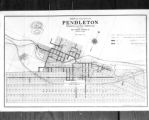 |
M.L. Gordon, Copy of Map of City of Pendleton, Ore. | 1922-02-15 | Image/StillImage | dha_scnpp |
| 115 |
 |
Map based on Bunyan's "Pilgrim's Progress" | | Image | uu_aah_art |
| 116 |
 |
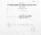
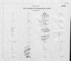
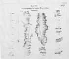
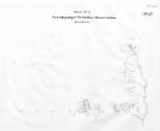
Map of a portion of the Uncompahgre Ute Indian Reservation | 1908 | Image/StillImage | uaida_main |
| 117 |
 |
Map of a portion of the Uncompahgre Ute Indian Reservation, surveyed and subdivided for allotments to the Uncompahgre Ute Indians in accordance with the Act approved June 1880 by authority of Honorable N. C. McFarland, Commissioner General Land Office Daniel G. Major U.S. Surveyor 1882-1883 | 1882; 1883 | Image/StillImage | uaida_main |
| 118 |
 |
Map of America | | Image | uu_aah_art |
| 119 |
 |
Map of Chief Washakie's Hunting and Fighting Territory, prepare by Oscar Mosserly, 1930 | | Image/StillImage | uaida_main |
| 120 |
 |
Map of Constantinople | | Image | uu_aah_art |
| 121 |
 |
Map of Dry Gulch Irrigation District, Uintah Indian Reservation, Utah | | Image/StillImage | uaida_main |
| 122 |
 |
Map of Dutch East India Company (V.O.C.) Trade Routes | | Image | uu_aah_art |
| 123 |
 |
Map of East Central Utah, Uintah Ouray Reservation, Utah Valley | | Image/StillImage | uaida_main |
| 124 |
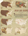 |
Map of Indian Land Cessions in the United States | | Image/StillImage | uaida_main |
| 125 |
 |
Map of Indian Reservation in the West, 1929 | | Image/StillImage | uaida_main |
| 126 |
 |
Map of Indian Reservation. 1884 | | Image/StillImage | uaida_main |
| 127 |
 |
Map of Indian Reservations in the Western United States | | Image/StillImage | uaida_main |
| 128 |
 |
Map of Indian Territory in the Western United States | | Image/StillImage | uaida_main |
| 129 |
 |
Map of Indian Tribes of North America | | Image/StillImage | uaida_main |
| 130 |
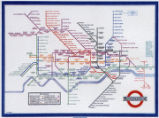 |
Map of London Underground, After Re-Design | | Image | uu_aah_art |
| 131 |
 |
Map of Navajo, Ute, and Jicarilla Apache Indian Reserves | | Image/StillImage | uaida_main |
| 132 |
 |
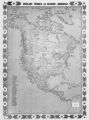
Map of North America and Original Inhabitants' Territory. | | Image/StillImage | uaida_main |
| 133 |
 |
Map of Northern Utah, Early Settlements | | Image/StillImage | uaida_main |
| 134 |
 |
Map of Part of the West Boundary of the Uncompahgre Ute Indian Reservation as Surveyed by William B. Dougall | | Image/StillImage | uaida_main |
| 135 |
 |
Map of Reservations of the Western United States and the Religions that Worked on the Reservations 1870's | 1873 | Image/StillImage | uaida_main |
| 136 |
 |
Map of Shoshone Indian Territory, and the Division of Shoshone Boundaries in Nevada | | Image/StillImage | uaida_main |
| 137 |
 |
Map of Shoshone Territory; Prepared by Doty, 1859 | | Image/StillImage | uaida_main |
| 138 |
 |
Map of Southern Colorado and the Ute Mountain Ute Reservation | | Image/StillImage | uaida_main |
| 139 |
 |
Map of Stock Mining Claims in the Uintah Basin | | Image/StillImage | uaida_main |
| 140 |
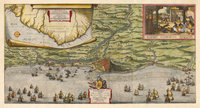 |
Map of the Dutch capture of the town of Olinda in Pernambuco by the Dutch West Indies Company in February 1630 | | Image | uu_aah_art |
| 141 |
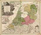 |
Map of the Dutch Republic | | Image | uu_aah_art |
| 142 |
 |
Map of the Four Corners Region and the Reservation of the Ute Mountain Ute Tribe | | Image/StillImage | uaida_main |
| 143 |
 |
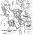
Map of the Homelands of Northern Shoshone, 1863 | | Image/StillImage | uaida_main |
| 144 |
 |
Map of the Northern Part of the Former Uintah Indian Reservation Showing the Irrigation System | | Image/StillImage | uaida_main |
| 145 |
 |
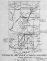
Map of the original range of the Bannock Indians according to Bureau of Indian Affairs, 1952. | | Image/StillImage | uaida_main |
| 146 |
 |
Map of the Pacific | | Image | uu_aah_art |
| 147 |
 |
Map of the Shoshone Tribes | | Image/StillImage | uaida_main |
| 148 |
 |
Map of the South West Boundary of the Uintah Indian Reserve Utah Territory. | | Image/StillImage | uaida_main |
| 149 |
 |
Map of the Southern Part of the Former Uintah Indian Reservation Showing the Irrigation System of Indian Allotments | | Image/StillImage | uaida_main |
| 150 |
 |
Map of the Uintah Basin and the Uintah Ouray Reservation | | Image/StillImage | uaida_main |
| 151 |
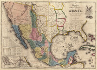 |
Map of the United States of Méjico (Mexico) | | Image | uu_aah_art |
| 152 |
 |
Map of Uintah Basin and Fort Duchesne | | Image/StillImage | uaida_main |
| 153 |
 |
Map of Uintah Reservation. Green River Area | | Image/StillImage | uaida_main |
| 154 |
 |
Map of Uintah Valley Reserve, formed by order of President Abraham Lincoln, 1861. | | Image/StillImage | uaida_main |
| 155 |
 |
Map of Uncompahgre Ute Indian Reservation Boundaries, Sheet Number 1, 1889 | | Image/StillImage | uaida_main |
| 156 |
 |
Map of Uncompahgre Ute Indian Reservation Boundaries, Sheet Number 2, 1889 | | Image/StillImage | uaida_main |
| 157 |
 |
Map of Uncompahgre Ute Indian Reservation Boundaries, Sheet Number 3, 1889 | | Image/StillImage | uaida_main |
| 158 |
 |
Map of Uncompahgre Ute Indian Reservation Boundaries, Sheet Number 4, 1889 | | Image/StillImage | uaida_main |
| 159 |
 |
Map of Uncompahgre Ute Indian Reservation Boundaries, Sheet Number 5, 1889 | | Image/StillImage | uaida_main |
| 160 |
 |
Map of Uncompahgre Ute Indian Reservation Boundaries, Sheet Number 6, 1889 | | Image/StillImage | uaida_main |
| 161 |
 |
Map of Uncompahgre Ute Indian Reservation Boundaries, Sheet Number 7, 1889 | | Image/StillImage | uaida_main |
| 162 |
 |
Map of Uncompahgre Ute Indian Reservation Boundaries, Sheet Number 8, 1889 | | Image/StillImage | uaida_main |
| 163 |
 |
Map of Uncompahgre Ute reservation, Includes parcel divisions | | Image/StillImage | uaida_main |
| 164 |
 |
Map of Utah with Cross | 1951-10-18 | Image | dha_scp |
| 165 |
 |
Map of Ute Reservation in Western Colorado, and Lands Ceded Over Time | 1882 | Image/StillImage | uaida_main |
| 166 |
 |
Map of Ute Territory by Band | | Image/StillImage | uaida_main |
| 167 |
 |
Map of Ute Territory in Utah and Colorado by Band Name and Location | | Image/StillImage | uaida_main |
| 168 |
 |
Map of Walker River Paiute Tribe Original Reservation Centennial 1874-1974 | 1874 | Image/StillImage | uaida_main |
| 169 |
 |
Map of Western Indian Territory Before 1850 | | Image/StillImage | uaida_main |
| 170 |
 |
Map of Western Shoshone and Northern Paiute Territory | | Image/StillImage | uaida_main |
| 171 |
 |
Map on Wall at Walgreen Drug Store, May 1936 | 1936-05-28 | Image | dha_cbfm |
| 172 |
 |
Map on Wall at Walgreen Drug Store, May 1936 | 1936-05-28 | Image | dha_cbfm |
| 173 |
 |
Map showing boundaries of Northern Paiute, Southern Paiute, Shoshone Bannock and Ute | | Image/StillImage | uaida_main |
| 174 |
 |
Map showing Ravenna and Aachen | | Image | uu_aah_art |
| 175 |
 |
Map showing the boundary of the Shoshone Indian territory | 1941 | Image/StillImage | uaida_main |
| 176 |
 |
Map showing the dissolution of the former Roman Empire, c. 600 | | Image | uu_aah_art |
| 177 |
 |
Map showing three locations of Zhuang Hui's site-specific project "Longitude 109.88°E and Latitude 31.09°N | | Image | uu_aah_art |
| 178 |
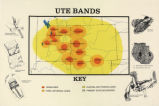 |
Map titled "Ute Bands Map" | | Image/StillImage | uaida_main |
| 179 |
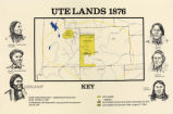 |
Map titled "Ute Lands, 1876" | | Image/StillImage | uaida_main |
| 180 |
 |
Map titled, "Northern Ute Lands, 1905" | | Image/StillImage | uaida_main |
| 181 |
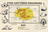 |
Map titled, "Utes and Their Neighbors" | | Image/StillImage | uaida_main |
| 182 |
 |
Map, annotated | 1975 | Image | dha_eftl |
| 183 |
 |
Map, July 1938 | 1938-07-12 | Image | dha_cbfm |
| 184 |
 |
Map, July 1938 | 1938-07-12 | Image | dha_cbfm |
| 185 |
 |
Map, Mar. 1938 | 1938-03-03 | Image | dha_cbfm |
| 186 |
 |
Map, Mar. 1938 | 1938-03-03 | Image | dha_cbfm |
| 187 |
 |
Map, Mar. 1938 | 1938-03-03 | Image | dha_cbfm |
| 188 |
 |
Map, May 1938 | 1938-05-16 | Image | dha_cbfm |
| 189 |
 |
Map, Salt Lake Valley | 1975 | Image | dha_eftl |
| 190 |
 |
Map: 11th - 12th Century Trade Routes | | Image | uu_aah_art |
| 191 |
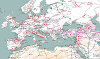 |
Map: 11th - 12th Century Trade Routes including Rome, Constantinople, Damascus, Jerusalem, and Dura-Europos | | Image | uu_aah_art |
| 192 |
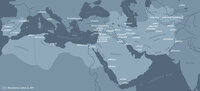 |
Map: Abbasid caliphate | | Image | uu_aah_art |
| 193 |
 |
Map: Ancient Egypt | | Image | uu_aah_art |
| 194 |
 |
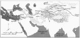
Map: Ancient Near East | | Image | uu_aah_art |
| 195 |
 |
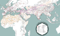
Map: Ancient Silk Routes between China and the West | | Image | uu_aah_art |
| 196 |
 |
Map: Approximate Spheres and Succession of the Xia, Shang, and Zhou Dynasties | | Image | uu_aah_art |
| 197 |
 |
Map: Areas in northeast Brazil occupied by the Dutch, showing the main regions under Johan Maurits van Nassau's rule, 1637 - 1644 | | Image | uu_aah_art |
| 198 |
 |
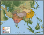
Map: Asia circa 1250 CE | | Image | uu_aah_art |
| 199 |
 |
Map: Asia circa 450 CE | | Image | uu_aah_art |
| 200 |
 |
Map: Asia circa 850 CE | | Image | uu_aah_art |