Home
Browse
Ask Us
Chat
Harmful Language Statement
Log in
Advanced Search
Year
1872
1873
1874
1875
1876
1877
1878
1879
1880
1881
1882
1883
1884
1885
1886
1887
1888
1889
1890
1891
1892
1893
1894
1895
1896
1897
1898
1899
1900
1901
1902
1903
1904
1905
1906
1907
1908
1909
1910
1911
1912
1913
1914
1915
1916
1917
1918
1919
1920
1921
1922
1923
1924
1925
1926
1927
1928
1929
1930
1931
1932
1933
1934
1935
1936
1937
1938
1939
1940
1941
1942
1943
1944
1945
1946
1947
1948
1949
1950
1951
1952
1953
1954
1955
1956
1957
1958
1959
1960
1961
1962
1963
1964
1965
1966
1967
1968
1969
1970
1971
1972
1973
1974
1975
1976
1977
1978
1979
1980
1981
1982
1983
1984
1985
1986
1987
1988
1989
1990
1991
1992
1993
1994
1995
TO
1872
1873
1874
1875
1876
1877
1878
1879
1880
1881
1882
1883
1884
1885
1886
1887
1888
1889
1890
1891
1892
1893
1894
1895
1896
1897
1898
1899
1900
1901
1902
1903
1904
1905
1906
1907
1908
1909
1910
1911
1912
1913
1914
1915
1916
1917
1918
1919
1920
1921
1922
1923
1924
1925
1926
1927
1928
1929
1930
1931
1932
1933
1934
1935
1936
1937
1938
1939
1940
1941
1942
1943
1944
1945
1946
1947
1948
1949
1950
1951
1952
1953
1954
1955
1956
1957
1958
1959
1960
1961
1962
1963
1964
1965
1966
1967
1968
1969
1970
1971
1972
1973
1974
1975
1976
1977
1978
1979
1980
1981
1982
1983
1984
1985
1986
1987
1988
1989
1990
1991
1992
1993
1994
1995
Type
Image/StillImage
17
Text
11
Image
1
Sound
1
Format
image/jpeg
30
Collection
Shipler Commercial Photographers
1
UAIDA Main Collection
29
Filters:
Format:
"image/jpeg"
Subject:
"Land use"
Year End:
2016
1
-
25
of
30
<
1
2
>
Gallery view
Number of results to display per page
10
25
50
100
200
Sort by Relevance
Sort by Title A-Z
Sort by Title Z-A
Sort by Date Ascending
Sort by Date Descending
Sort by Last Modified Ascending
Sort by Last Modified Descending
Title
Date
Type
Setname
1
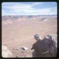
A man and a young boy and girl standing in front of a hogan
1970; 1971; 1972; 1973; 1974; 1975; 1976; 1977; 1978; 1979; 1980; 1981; 1982; 1983; 1984; 1985; 1986; 1987; 1988; 1989
Image/StillImage
uaida_main
2
A Precarious Balance: The Northern Utes And The Black Hawk War
1989
Text
uaida_main
3
An Anguished Odyssey: the Flight of the Utes, 1906-1908
1968
Text
uaida_main
4
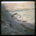
Blue and white truck parked in canyon, river
1970; 1971; 1972; 1973; 1974; 1975; 1976; 1977; 1978; 1979; 1980; 1981; 1982; 1983; 1984; 1985; 1986; 1987; 1988; 1989
Image/StillImage
uaida_main
5
Boundary of Shoshone Indian Territory according to Swanton, 1952
1952
Image/StillImage
uaida_main
6
Boundary of Shoshone Indian Territory and Neighboring Tribes
1957
Image/StillImage
uaida_main
7
Boundary of Shoshone Indian Territory, Linguistic Boundaries of Shoshone and Bannock.
1941
Image/StillImage
uaida_main
8
Boundary of Shoshone Indian Territory, showing the locations of the Bannock
1957
Image/StillImage
uaida_main
9
Boundary of Shoshone Indian Territory, showing the locations of the Bannock from 1819 to 1951
1957
Image/StillImage
uaida_main
10
Boundary of Shoshone Indian Territory, showing the locations where the Bannock and Shoshone reported together 1819-1956
1957
Image/StillImage
uaida_main
11
Boundary of Shoshone Indian Territory; Doty Map of 1863 Indian Claims Commission
1957
Image/StillImage
uaida_main
12
Father Escalante and the Utah Indians
1928; 1929; 1930; 1931; 1932; 1933
Text
uaida_main
13
Father Liebler looking down over the mission
1970; 1971; 1972; 1973; 1974; 1975; 1976; 1977; 1978; 1979; 1980; 1981; 1982; 1983; 1984; 1985; 1986; 1987; 1988; 1989
Image/StillImage
uaida_main
14
Fort Duchesne's Beginnings
1928; 1929; 1930; 1931; 1932; 1933
Text
uaida_main
15
Group Portrait
1962-05-02
Image
dha_scp
16
Indian Country
1971
Text
uaida_main
17
Indian Reminiscences
1928; 1929; 1930; 1931; 1932; 1933
Text
uaida_main
18
Indian Reservations in Utah, and Uintah and Ouray Indian Agency, Fort Duchesne, Utah
1928; 1929; 1930; 1931; 1932; 1933
Text
uaida_main
19
Indians on the Old Spanish Trail
1928; 1929; 1930; 1931; 1932; 1933
Text
uaida_main
20
Interview with Roy Atine
1968-08-07
Sound
uaida_main
21
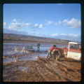
Man standing next to a car that is buried in mud. Two men, one wearing a red shirt, trying to push a red and white truck
1970; 1971; 1972; 1973; 1974; 1975; 1976; 1977; 1978; 1979; 1980; 1981; 1982; 1983; 1984; 1985; 1986; 1987; 1988; 1989
Image/StillImage
uaida_main
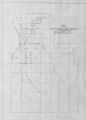
22
Map of a portion of the Uncompahgre Ute Indian Reservation
1908
Image/StillImage
uaida_main
23
Map of a portion of the Uncompahgre Ute Indian Reservation, surveyed and subdivided for allotments to the Uncompahgre Ute Indians in accordance with the Act approved June 1880 by authority of Honorable N. C. McFarland, Commissioner General Land Office Daniel G. Major U.S. Surveyor 1882-1883
1882; 1883
Image/StillImage
uaida_main
24
Map of Reservations of the Western United States and the Religions that Worked on the Reservations 1870's
1873
Image/StillImage
uaida_main
25
Map of Ute Reservation in Western Colorado, and Lands Ceded Over Time
1882
Image/StillImage
uaida_main
1
-
25
of
30
<
1
2
>