1 - 25 of 8
Number of results to display per page
| Title | Date | Type | Setname | ||
|---|---|---|---|---|---|
| 1 |  | Black Hills and the northeast portion of the Powder River Basin, Montana and Wyoming | 1975-11 | Text | uum_frcp |
| 2 |  | Drill holes in Lakota formation, Black Hills, 1971 | 1971-07-13 | Text | uum_frcp |
| 3 |  | Federal Resources Corporation Black Hills district: drilling progress map, 1973, July report | 1973-07 | Text | uum_frcp |
| 4 | 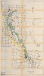 | Federal Resources Corporation Black Hills project: map showing leases and claims with some geology | 1969-12-01 | Text | uum_frcp |
| 5 | 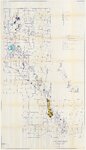 | Federal Resources Corporation Black Hills project: map showing leases and claims with some geology | 1972-11-10 | Text | uum_frcp |
| 6 |  | Federal Resources Corporation land map: North Black Hills fairway | 1972-11 | Text | uum_frcp |
| 7 |  | Outdoor scene with trees, tents, and deer or elk, Yellowstone | 1927 | Image/StillImage | uum_map |
| 8 | 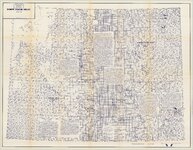 | Wyoming uranium project index map | 1970; 1971; 1972; 1973; 1974; 1975; 1976 | Text | uum_frcp |
1 - 25 of 8